Tag Archives: boating

Angelina National Forest

Angelina National Forest

Texas

Managed by U.S. Forest Service, Southern Region

402,231 acres (153,180 federal/ 249,051 other)

Website: https://www.fs.usda.gov/main/texas/home

Overview

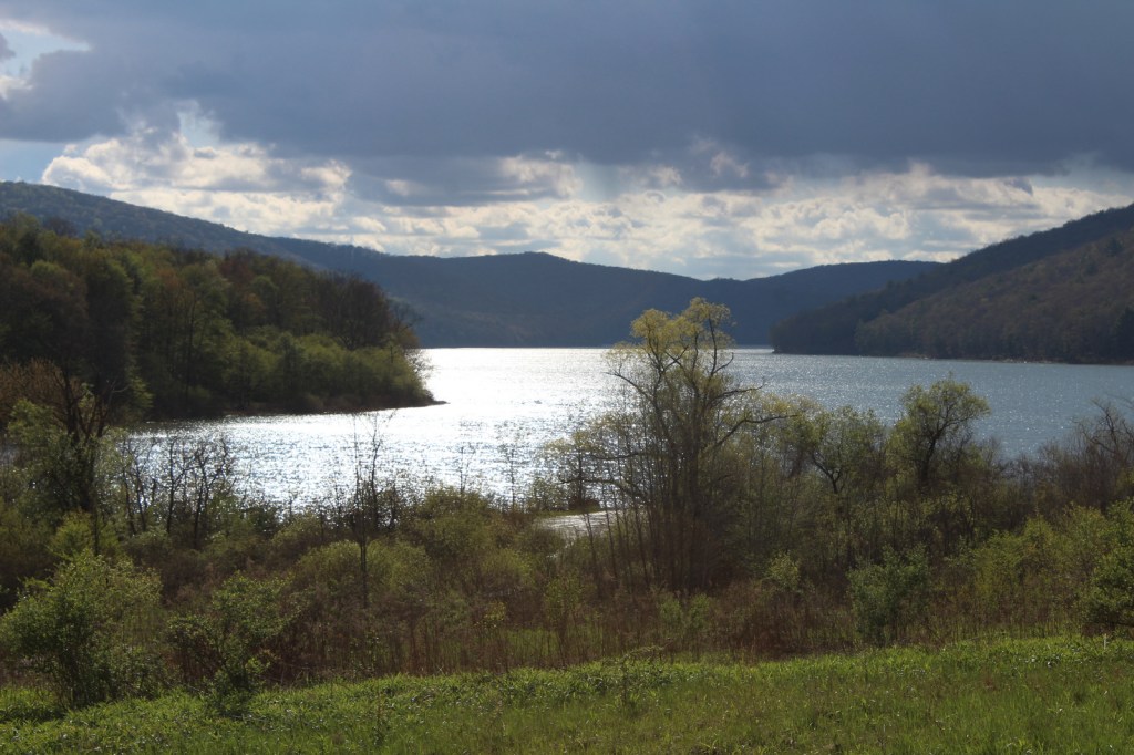
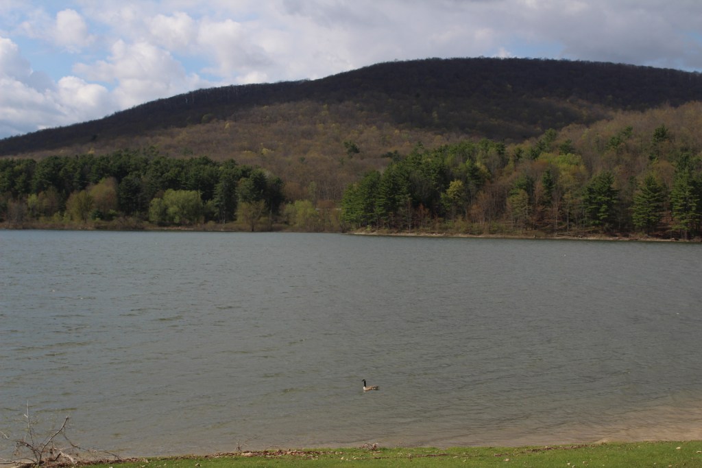
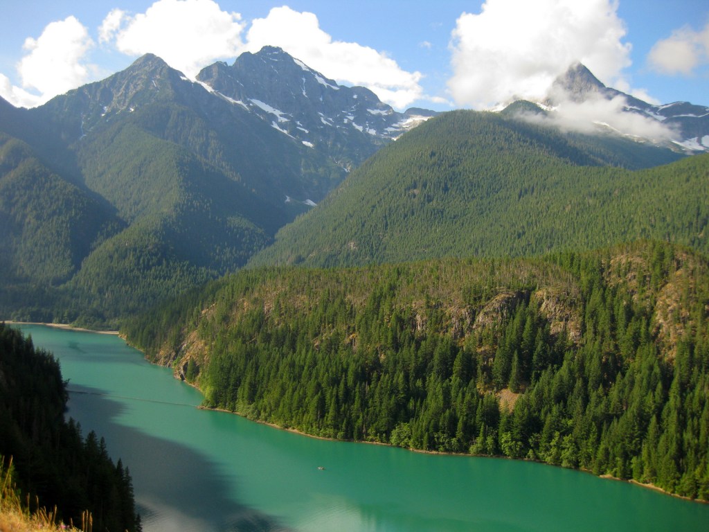
Angelina National Forest lies in the piney woods region of eastern Texas dominated by longleaf, loblolly, and shortleaf pine trees.  In 1935, land acquisition began to create Angelina and the three other nearby National Forests it is co-managed with (Davy Crockett, Sabine, and Sam Houston).  Sam Rayburn Reservoir bisects Angelina National Forest into a north and south section in the flooded Neches River Basin.

Highlights

Sam Rayburn Reservoir, Boykin Springs Recreation Area, Caney Creek Recreation Area, Black Branch Barrens, Bouton Lake, Aldridge Sawmill Historic Site, Sawmill Trail

Must-Do Activity

Other than Sam Rayburn Reservoir, the most developed portion of the National Forest is Boykin Springs Recreation Area.  The lake, campground, and Civilian Conservation Corps (CCC) structures are at the end of 2.5-mile long Forest Road 313 off Highway 63.  About twenty minutes away Bouton Lake (12 acres) is located seven miles down Forest Road 303 and offers primitive camping, fishing, and an overgrown hiking trail amidst bottomland hardwoods and baldcypress trees (please respect the private property on the west side).

Best Trail

The 5.5-mile out-and-back Sawmill Trail connects Boykin Springs Recreation Area to the Aldridge Sawmill Historic Site.  The trail goes through a burn and can be hard to follow in places due to multiple user trails, so be sure to follow the yellow-painted metal markers on trees.  The sawmill has been heavily sprayed with graffiti, but if you aim your camera up to the second story it does not look as bad.  The trail that used to connect to the sawmill from Bouton Lake has been closed since it crossed private property.

Watchable Wildlife

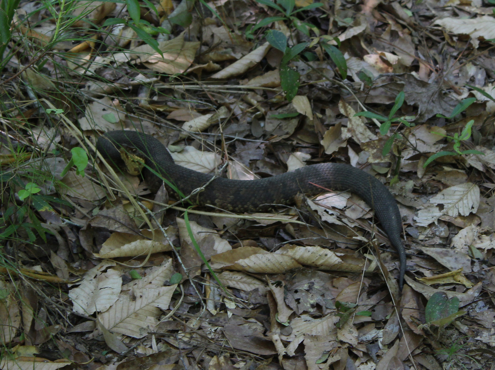
At Boykin Springs Recreation Area we spotted a pileated woodpecker, cardinal, robins, and crows.  The endangered red-cockaded woodpecker can be found in the longleaf pine forests.  On the Sawmill Trail we saw a copperhead snake near the creek and turtles in the pond at the end.  Hunters seek white-tailed deer, wild turkey, American woodcock, and bobwhite quail in the forest, which also provides wintering habitat for bald eagles.

Instagram-worthy Photo

A cool rock spillway originally built by the Civilian Conservation Corps (CCC) in 1938 drains from the nine-acre lake at Boykin Springs Recreation Area.  It was reconstructed to its original appearance in the years after Hurricane Rita hit in 2005.

Peak Season

Spring and fall

Fees

None

Road Conditions

Forest Road 303 to Bouton Lake is a very good dirt road, but the west side of the lake is privately owned and a one-lane road leads to a gate, so unless you want to drive backwards for a ways just park as soon as you get to the camping area.

Camping

There are developed campgrounds at Boykin Springs and Caney Creek Recreation Areas, plus an undeveloped (and free) area to camp at Bouton Lake.

Wilderness Areas

Turkey Hill Wilderness

Upland Island Wilderness

Related Sites

Big Thicket National Preserve (Texas)

Davy Crockett National Forest (Texas)

Sabine National Forest (Texas)

Nearest National Park

Hot Springs (Arkansas)

Conifer Tree Species

baldcypress, longleaf pine, shortleaf pine, loblolly pine

Flowering Tree Species

laurel oak, blackjack oak, post oak, overcup oak, swamp chestnut oak, cherrybark oak, water oak, black hickory, water hickory, red maple, American beech, American holly, yaupon holly, southern magnolia, sweetbay magnolia, swamp red bay, water tupelo, water elm, winged elm, Carolina ash, green ash, wax myrtle

Explore More – Other than looking cool, what function do the knees serve that protrude from the baldcypress root system?

We are a participant in the Amazon Services LLC Associates Program, an affiliate advertising program designed to provide a means for us to earn fees by linking to Amazon.com and affiliated sites.

Angeles National Forest

Angeles National Forest

California

Managed by U.S. Forest Service, Pacific Southwest Region

694,175 acres (668,887 federal/ 25,288 other)

Website: https://www.fs.usda.gov/angeles

Overview

Angeles National Forest is registered as a California Historical Landmark since it became the first protected woodland in the state as the San Gabriel Timberland Reserve in 1891.  It serves as a major recreation destination north of the Los Angeles metropolitan area with 697 miles of hiking trails, several lakes, and two alpine ski areas.  Most of the shrub and tree species are adapted to periodic fire and about one-quarter of the National Forest burned in the 2009 Station Fire and an additional 115,796 acres in the 2020 Bobcat Fire.

Highlights

San Gabriel Mountains National Monument, Saint Francis Dam Disaster National Memorial and Monument, Angeles Crest Highway, Crystal Lake Recreation Area, Mt. Wilson Observatory, Bouquet Reservoir, Mt. Baldy, San Antonio Falls, Gabrielino National Recreation Trail, High Desert National Recreation Trail, Pacific Crest National Scenic Trail

Must-Do Activity

Angeles Crest Highway (Highway 2) cuts through the San Gabriel Mountains National Monument, established in 2014.  Coming from the east, a good place to start is the Big Pines Visitor Center or the Grassy Hollow Visitor Center, both of which have short interpretive trails with signs identifying local species.  Further west, Saint Francis Dam Disaster National Memorial and Monument (est. 2019) commemorates the tragedy that cost at least 431 people their lives in 1928.  Watch in the coming weeks for blog posts specifically detailing these two National Monuments.

Best Trail

Across from Inspiration Point on Highway 2, there is a parking lot for Lightning Ridge Nature Trail.  The half-mile loop trail offers great panoramas of the surrounding mountains.  It even includes a portion of the 2,600-mile Pacific Crest National Scenic Trail.  Along the trail, my wife and I stopped to sniff the orange, platy bark of a Jeffrey pine for its pleasant vanilla scent, which brought back memories of our time spent living in California. 

Watchable Wildlife

On our November visit, we first saw a western gray squirrel with an incredibly poofy tail atop the Big Pines Visitor Center.  On the Big Pines Interpretive Trail, we spotted dark-eyed juncos and Steller jays flitting about.  Despite its proximity to the city, there are even black bears, mountain lions, and bobcats in this National Forest.  You are more likely to come across coyotes, gray foxes, or mule deer.

Instagram-worthy Photo

Many species commonly found in this National Forest are endemic to this region and grow nowhere else on Earth, including Coulter pine (famous for its massive pinecones that weigh up to 11 pounds).

Peak Season

Spring and fall

Fees

An Adventure Pass is required to park at many trailheads.  The Forest Service also accepts all America the Beautiful Passes, which can be also used at National Park Service sites.

Road Conditions

The paved Angeles Crest Highway cuts through San Gabriel Mountains National Monument and it used to go through to Glendale, but closed due to damage from the 2020 Bobcat Fire.

Camping

There are many campgrounds in the National Forest, but we did not see any great places to do dispersed car camping when we drove through different portions of it (although we did not drive any dirt roads which is where they typically are found).

Wilderness Areas

Cucamonga Wilderness (also in San Bernardino National Forest)

Magic Mountain Wilderness

Pleasant View Ridge Wilderness

San Gabriel Wilderness

Sheep Mountain Wilderness (also in San Bernardino National Forest)

Related Sites

Pinnacles National Park (California)

Santa Monica Mountains National Recreation Area (California)

César E. Chávez National Monument (California)

Nearest National Park

Channel Islands (California)

Conifer Tree Species

incense-cedar, bigcone Douglas-fir, Jeffrey pine, Coulter pine, knobcone pine, gray pine, lodgepole pine

Flowering Tree/Shrub Species

California black oak, canyon live oak, California walnut, serviceberry, western mountain-mahogany, California coffeeberry, cup-leaf ceonothus, flannel bush, Parry’s manzanita

Explore More – How long are the Gabrielino and High Desert National Recreation Trails?

Allegheny National Recreation Area

Allegheny National Recreation Area

Pennsylvania

Managed by U.S. Forest Service, Allegheny National Forest

24,145 acres

Website: https://www.fs.usda.gov/attmain/allegheny/specialplaces/

Overview

Allegheny National Recreation Area was created by Congress in 1984 under the Pennsylvania Wilderness Act.  It is managed as three separate parcels of land within Allegheny National Forest.  The first is named Cornplanter after an Iroquois warrior and leader during the American Revolution and it has two boat launches and no developed trails on the federal lands west of the Allegheny Reservoir.  The second is Tracy Ridge to the east of the reservoir, which we will discuss below.  Farther south, the third parcel is the Allegheny Front on the east side of the Allegheny River from Charlie Run to South Slater Run, bordered on the west by Highway 62.

Highlights

Willow Bay Recreation Area, Tracy Ridge Hiking Trail System, North Country National Scenic Trail

Must-Do Activity

Tracy Ridge is easily accessible from scenic State Highway 321 and it has an extensive system of hiking trails, including a 10-mile section of the North Country National Scenic Trail.  Further north, Willow Bay Recreation Area (day-use fee) is the most developed portion of Allegheny National Recreation Area.  The waters of the Allegheny Reservoir between Cornplanter and Tracy Ridge are also considered to be part of the National Recreation Area with three developed boat-in campgrounds (fee). 

Best Trail

In addition to the Tracy Ridge Hiking Trail System, the undeveloped Allegheny Front parcel contains a three-mile segment of the Tanbark Trail.  These areas are popular with hunters, so remember to wear fluorescent clothing during hunting seasons.

Instagram-worthy Photo

While having lunch near the dock in Willow Bay Recreation Area, we saw a bald eagle, a red-tailed hawk, ravens, and a flock of Canada geese.

Peak Season

Summer

Fees

There is an entrance fee at Willow Bay Recreation Area, but it is half price with an America the Beautiful pass.  Even if you hike in to Hopewell and Handsome Lake Campgrounds on the shores of the Allegheny Reservoir, you need to pay the overnight camping fee.  Based on the signs, we think that backpacking in Tracy Ridge is free.

Road Conditions

We did not come across any unpaved roads while driving through Allegheny National Recreation Area, but they probably exist.

Camping

Willow Bay Recreation Area and Tracy Ridge have drive-in campgrounds, plus Hooks Brook, Hopewell, and Handsome Lake are accessible by boat.  Dispersed camping is allowed for no more than 14 consecutive days at one site and not within 1500 feet of the Allegheny Reservoir.  The same goes for backpacking sites on the Tracy Ridge Hiking Trail System where hanging bear bags or using bear-proof containers is recommended.

Related Sites

Allegheny National Forest (Pennsylvania)

Allegheny Portage Railroad National Historic Site (Pennsylvania)

Flight 93 National Memorial (Pennsylvania)

Nearest National Park

Cuyahoga Valley (Ohio)

Explore More – When it is completed, how long will the North Country National Scenic Trail be in its entirety?

Allegheny National Forest

Allegheny National Forest

Pennsylvania

Managed by U.S. Forest Service, Eastern Region

742,693 acres (513,175 federal/ 229,518 other)

Website: https://www.fs.usda.gov/allegheny

Overview

The only National Forest in Pennsylvania was created in 1923 utilizing the federal government’s ability to purchase land under the Weeks Act of 1911.  However, they could not afford the subsurface or mineral rights, which has created issues in this oil-producing area.  Before it became Allegheny National Forest, most of the hillsides were clearcut to feed the area’s wood chemical plants, allowing black cherry and early successional species to dominate the second growth forests.  The National Forest contains two Wild and Scenic Rivers: the Clarion River (51.7 miles) and Allegheny River (87 miles in three separate sections).

Highlights

Allegheny National Recreation Area, Hearts Content Scenic Area, Willow Bay Recreation Area, Old Powerhouse, Timberdoodle Flats Interpretive Trail, Minister Creek, Buzzard Swamp Hiking Area, Clarion Wild and Scenic River, Allegheny Wild and Scenic River, Buckaloons Recreation Area, Hall Barn Wildlife Viewing Area, North Country National Scenic Trail

Must-Do Activity

A good place to start exploring Allegheny National Forest is by driving the Longhouse Scenic Byway, a 36-mile loop, which includes views of the Allegheny Reservoir and Kinzua Dam, plus a side trip up to Jakes Rocks Overlook.  We drove in from the east and found the easy walks on the Timberdoodle Flats Wildlife Interpretive Trail to be a good introduction to this region.  This is one of the few places in Pennsylvania with old-growth forests, so be sure to stop at Hearts Content Scenic Area or Tionesta Scenic and Research Natural Areas. 

Best Trail

Huge eastern hemlock and eastern white pine trees up to 400 years old can be found in the 20-acre Hearts Content Scenic Area.  This National Natural Landmark has a picnic area constructed by the Civilian Conservation Corps (CCC) and is located across from a nice campground.  There are two short, flat loop trails located here, but you can also connect into 7.8 miles of cross-country skiing and snowshoeing routes.  Other popular hiking destinations include Rimrock Trail and a 10-mile section of the North Country National Scenic Trail within the Tracy Ridge Hiking Trail System (see our post on Allegheny National Recreation Area for more information).

Watchable Wildlife

As hard as it is to believe given their prevalence now, low populations of white-tailed deer in the 1920s allowed this new National Forest to grow back quickly.  Campers should exercise caution with their food and trash since black bears are in the area.  Turkeys, bald eagles, barred owls, Canada geese, black-capped chickadees, and pileated woodpeckers are common bird species.  Hall Barn Wildlife Viewing Area is known for its summer population of 1,000 roosting bats.  There is also evidence of beavers on the Timberdoodle Flats Wildlife Interpretive Trail.  Allegheny Reservoir has walleye, trout, bass, catfish, northern pike, and muskellunge, and small native brook trout can be found in the Farnsworth Stream and other creeks.  We recently learned that the PA Firefly Festival is held in Tionesta, Pennsylvania every June because of their population of synchronous fireflies (or lightning bugs).

Instagram-worthy Photo

Kinzua Dam was completed in 1965 and stands 179 feet tall and 1,897 feet in length.  Kinzua is a Seneca Indian word that translates as “place of many big fishes.”  Watch for fish that gather in eddies at the edges of the Allegheny Reservoir near the dam, but remember that fishing and feeding the fish is prohibited at this spot.

Peak Season

Summer

Fees

There is an entrance fee at both Willow Bay and Buckaloons Recreation Areas, but it is half price with an America the Beautiful pass.

Road Conditions

All roads are paved to Willow Bay Recreation Area and Hearts Content Scenic Area, which are popular with RV campers. 

Camping

Allegheny National Forest contains 15 campgrounds with more than 1,000 sites, and Willow Bay Recreation Area also has cabins for rent.  We enjoyed our stay at Heart’s Content Campground, but found Buckaloons Campground to be too crowded.  Allegheny Islands Wilderness has seven islands that can be used for boat-in dispersed camping.

Wilderness Areas

Allegheny Islands Wilderness

Hickory Creek Wilderness

Related Sites

Allegheny National Recreation Area (Pennsylvania)

Grey Towers National Historic Site (Pennsylvania)

Fort Necessity National Battlefield (Pennsylvania)

Nearest National Park

Cuyahoga Valley (Ohio)

Conifer Tree Species

eastern hemlock, eastern white pine

Flowering Tree Species

sugar maple, black maple, red maple, striped maple, silver maple, mountain maple, yellow birch, sweet birch, black walnut, bitternut hickory, shagbark hickory, sycamore, American beech, white ash, tulip-poplar, green ash, cucumber magnolia, quaking aspen, bigtooth aspen, black cherry, pin cherry, choke cherry, northern red oak, basswood, American elm, slippery elm

Explore More – Timberdoodle is a local nickname for which native bird species that nests in this forest?

Ross Lake National Recreation Area

Overview

Bisecting the two sections of North Cascades National Park in northern Washington is Ross Lake National Recreation Area.  The incredibly scenic Highway 20 (closed seasonally) cuts through the mountains here, less than two hours from Seattle.  The rainshadow effect is readily apparent to anyone who crosses these mountains from the lush west to the arid eastern portion of the state.  Access to the only boat ramp on Ross Lake actually requires a drive through Canada, but you can also pick up a water taxi near Diablo Dam.

Highlights

Diablo Lake Overlook, Gorge Creek Falls, Ross Lake Resort, Sourdough Mountain Trail

Must-Do Activity

If coming from Seattle, start your visit at the North Cascades National Park Visitor Center on the scenic North Cascades Highway (20).  Ross Lake National Recreation Area contains three hydroelectric reservoirs, which have an interesting turquoise color due to glacial silt, especially evident at Diablo Lake Overlook.  Nearby, Colonial Creek Campground offers a peaceful forest in which to spend the night and a good jumping off place for a day hike on Thunder Creek or Fourth of July Trails through old-growth forests with colossal mushroom conchs and giant banana slugs.

Best Trail

Summiting Desolation Peak is often found on the bucket lists of the writer Jack Kerouac’s biggest fans, as he did some of his best writing while stationed as a fire lookout here in 1956.  The observation tower is not far from the Canadian border and the trek is a daunting task, typically utilizing a water taxi to cross Ross Lake.

Instagram-worthy Photo

Do not drive past Diablo Lake Overlook, an awe inspiring and usually gusty stop along Highway 20.  The craggy heights of the geologically young mountains surrounding this spectacular reservoir are magnificent to behold, yet forbidding to enter.

Peak Season

Late summer

Hours

https://www.nps.gov/noca/planyourvisit/hours.htm

Fees

None

Road Conditions

The North Cascades Highway (20) is typically closed east of Ross Dam from mid-November through mid-April (or later).  The unpaved road to Thornton Lakes Trailhead is not suitable for trailers.

Camping

Colonial Creek Campground (164 sites) is only one option, additionally there are Newhalem Creek (119 sites), Goodell Creek (22 sites), and Hozomeen (122 sites accessed via a 40-mile gravel road from Hope, British Columbia).  For the full backcountry experience, pick up a free backpacking permit at the Wilderness Information Center in Marblemount, Washington.

Related Sites

Lake Chelan National Recreation Area (Washington)

Lake Roosevelt National Recreation Area (Washington)

Klondike Gold Rush National Historical Park (Alaska-Washington)

Explore More – Only two miles across at its widest point, how long is Ross Lake?