Tag Archives: trees

Angeles National Forest

Angeles National Forest

California

Managed by U.S. Forest Service, Pacific Southwest Region

694,175 acres (668,887 federal/ 25,288 other)

Website: https://www.fs.usda.gov/angeles

Overview

Angeles National Forest is registered as a California Historical Landmark since it became the first protected woodland in the state as the San Gabriel Timberland Reserve in 1891.  It serves as a major recreation destination north of the Los Angeles metropolitan area with 697 miles of hiking trails, several lakes, and two alpine ski areas.  Most of the shrub and tree species are adapted to periodic fire and about one-quarter of the National Forest burned in the 2009 Station Fire and an additional 115,796 acres in the 2020 Bobcat Fire.

Highlights

San Gabriel Mountains National Monument, Saint Francis Dam Disaster National Memorial and Monument, Angeles Crest Highway, Crystal Lake Recreation Area, Mt. Wilson Observatory, Bouquet Reservoir, Mt. Baldy, San Antonio Falls, Gabrielino National Recreation Trail, High Desert National Recreation Trail, Pacific Crest National Scenic Trail

Must-Do Activity

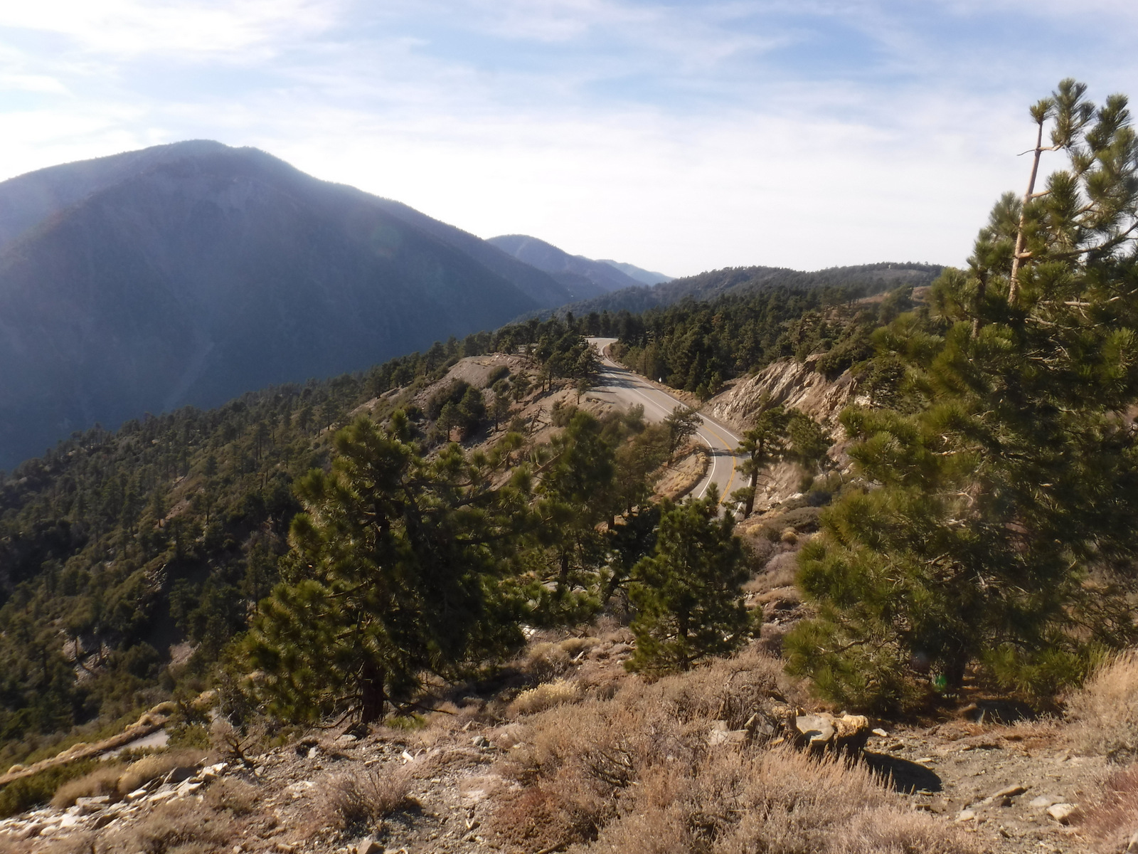
Angeles Crest Highway (Highway 2) cuts through the San Gabriel Mountains National Monument, established in 2014.  Coming from the east, a good place to start is the Big Pines Visitor Center or the Grassy Hollow Visitor Center, both of which have short interpretive trails with signs identifying local species.  Further west, Saint Francis Dam Disaster National Memorial and Monument (est. 2019) commemorates the tragedy that cost at least 431 people their lives in 1928.  Watch in the coming weeks for blog posts specifically detailing these two National Monuments.

Best Trail

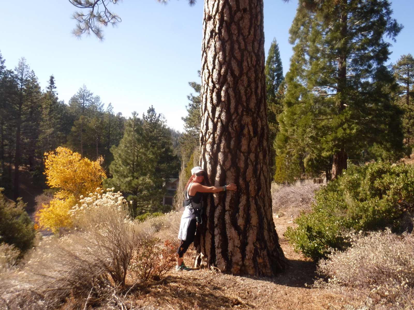
Across from Inspiration Point on Highway 2, there is a parking lot for Lightning Ridge Nature Trail.  The half-mile loop trail offers great panoramas of the surrounding mountains.  It even includes a portion of the 2,600-mile Pacific Crest National Scenic Trail.  Along the trail, my wife and I stopped to sniff the orange, platy bark of a Jeffrey pine for its pleasant vanilla scent, which brought back memories of our time spent living in California. 

Watchable Wildlife

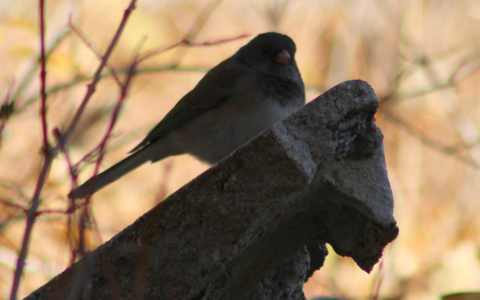
On our November visit, we first saw a western gray squirrel with an incredibly poofy tail atop the Big Pines Visitor Center.  On the Big Pines Interpretive Trail, we spotted dark-eyed juncos and Steller jays flitting about.  Despite its proximity to the city, there are even black bears, mountain lions, and bobcats in this National Forest.  You are more likely to come across coyotes, gray foxes, or mule deer.

Instagram-worthy Photo

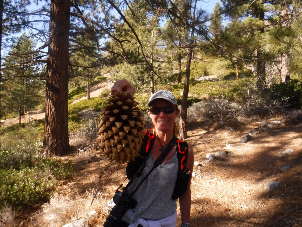
Many species commonly found in this National Forest are endemic to this region and grow nowhere else on Earth, including Coulter pine (famous for its massive pinecones that weigh up to 11 pounds).

Peak Season

Spring and fall

Fees

An Adventure Pass is required to park at many trailheads.  The Forest Service also accepts all America the Beautiful Passes, which can be also used at National Park Service sites.

Road Conditions

The paved Angeles Crest Highway cuts through San Gabriel Mountains National Monument and it used to go through to Glendale, but closed due to damage from the 2020 Bobcat Fire.

Camping

There are many campgrounds in the National Forest, but we did not see any great places to do dispersed car camping when we drove through different portions of it (although we did not drive any dirt roads which is where they typically are found).

Wilderness Areas

Cucamonga Wilderness (also in San Bernardino National Forest)

Magic Mountain Wilderness

Pleasant View Ridge Wilderness

San Gabriel Wilderness

Sheep Mountain Wilderness (also in San Bernardino National Forest)

Related Sites

Pinnacles National Park (California)

Santa Monica Mountains National Recreation Area (California)

César E. Chávez National Monument (California)

Nearest National Park

Channel Islands (California)

Conifer Tree Species

incense-cedar, bigcone Douglas-fir, Jeffrey pine, Coulter pine, knobcone pine, gray pine, lodgepole pine

Flowering Tree/Shrub Species

California black oak, canyon live oak, California walnut, serviceberry, western mountain-mahogany, California coffeeberry, cup-leaf ceonothus, flannel bush, Parry’s manzanita

Explore More – How long are the Gabrielino and High Desert National Recreation Trails?

Allegheny National Forest

Allegheny National Forest

Pennsylvania

Managed by U.S. Forest Service, Eastern Region

742,693 acres (513,175 federal/ 229,518 other)

Website: https://www.fs.usda.gov/allegheny

Overview

The only National Forest in Pennsylvania was created in 1923 utilizing the federal government’s ability to purchase land under the Weeks Act of 1911.  However, they could not afford the subsurface or mineral rights, which has created issues in this oil-producing area.  Before it became Allegheny National Forest, most of the hillsides were clearcut to feed the area’s wood chemical plants, allowing black cherry and early successional species to dominate the second growth forests.  The National Forest contains two Wild and Scenic Rivers: the Clarion River (51.7 miles) and Allegheny River (87 miles in three separate sections).

Highlights

Allegheny National Recreation Area, Hearts Content Scenic Area, Willow Bay Recreation Area, Old Powerhouse, Timberdoodle Flats Interpretive Trail, Minister Creek, Buzzard Swamp Hiking Area, Clarion Wild and Scenic River, Allegheny Wild and Scenic River, Buckaloons Recreation Area, Hall Barn Wildlife Viewing Area, North Country National Scenic Trail

Must-Do Activity

A good place to start exploring Allegheny National Forest is by driving the Longhouse Scenic Byway, a 36-mile loop, which includes views of the Allegheny Reservoir and Kinzua Dam, plus a side trip up to Jakes Rocks Overlook.  We drove in from the east and found the easy walks on the Timberdoodle Flats Wildlife Interpretive Trail to be a good introduction to this region.  This is one of the few places in Pennsylvania with old-growth forests, so be sure to stop at Hearts Content Scenic Area or Tionesta Scenic and Research Natural Areas. 

Best Trail

Huge eastern hemlock and eastern white pine trees up to 400 years old can be found in the 20-acre Hearts Content Scenic Area.  This National Natural Landmark has a picnic area constructed by the Civilian Conservation Corps (CCC) and is located across from a nice campground.  There are two short, flat loop trails located here, but you can also connect into 7.8 miles of cross-country skiing and snowshoeing routes.  Other popular hiking destinations include Rimrock Trail and a 10-mile section of the North Country National Scenic Trail within the Tracy Ridge Hiking Trail System (see our post on Allegheny National Recreation Area for more information).

Watchable Wildlife

As hard as it is to believe given their prevalence now, low populations of white-tailed deer in the 1920s allowed this new National Forest to grow back quickly.  Campers should exercise caution with their food and trash since black bears are in the area.  Turkeys, bald eagles, barred owls, Canada geese, black-capped chickadees, and pileated woodpeckers are common bird species.  Hall Barn Wildlife Viewing Area is known for its summer population of 1,000 roosting bats.  There is also evidence of beavers on the Timberdoodle Flats Wildlife Interpretive Trail.  Allegheny Reservoir has walleye, trout, bass, catfish, northern pike, and muskellunge, and small native brook trout can be found in the Farnsworth Stream and other creeks.  We recently learned that the PA Firefly Festival is held in Tionesta, Pennsylvania every June because of their population of synchronous fireflies (or lightning bugs).

Instagram-worthy Photo

Kinzua Dam was completed in 1965 and stands 179 feet tall and 1,897 feet in length.  Kinzua is a Seneca Indian word that translates as “place of many big fishes.”  Watch for fish that gather in eddies at the edges of the Allegheny Reservoir near the dam, but remember that fishing and feeding the fish is prohibited at this spot.

Peak Season

Summer

Fees

There is an entrance fee at both Willow Bay and Buckaloons Recreation Areas, but it is half price with an America the Beautiful pass.

Road Conditions

All roads are paved to Willow Bay Recreation Area and Hearts Content Scenic Area, which are popular with RV campers. 

Camping

Allegheny National Forest contains 15 campgrounds with more than 1,000 sites, and Willow Bay Recreation Area also has cabins for rent.  We enjoyed our stay at Heart’s Content Campground, but found Buckaloons Campground to be too crowded.  Allegheny Islands Wilderness has seven islands that can be used for boat-in dispersed camping.

Wilderness Areas

Allegheny Islands Wilderness

Hickory Creek Wilderness

Related Sites

Allegheny National Recreation Area (Pennsylvania)

Grey Towers National Historic Site (Pennsylvania)

Fort Necessity National Battlefield (Pennsylvania)

Nearest National Park

Cuyahoga Valley (Ohio)

Conifer Tree Species

eastern hemlock, eastern white pine

Flowering Tree Species

sugar maple, black maple, red maple, striped maple, silver maple, mountain maple, yellow birch, sweet birch, black walnut, bitternut hickory, shagbark hickory, sycamore, American beech, white ash, tulip-poplar, green ash, cucumber magnolia, quaking aspen, bigtooth aspen, black cherry, pin cherry, choke cherry, northern red oak, basswood, American elm, slippery elm

Explore More – Timberdoodle is a local nickname for which native bird species that nests in this forest?

Flight 93 National Memorial

Overview

One of the most emotionally difficult places we have ever visited is the Flight 93 National Memorial in southwest Pennsylvania.  Most readers remember the details of September 11, 2001 vividly and the feelings of that day still resonate.  Thanks to the courage of the 40 passengers and crew aboard United Flight 93, the airplane crashed only 18 minutes short of its target in Washington, D.C.

Highlights

Museum, Memorial Plaza, Wall of Names

Must-Do Activity

Even if you never saw the Hollywood film, the story of Flight 93 is well known.  The National Park Service (NPS) has put together a high-quality museum near the airplane crash site and the memorial itself is simple yet strong.  One wall is inscribed with this excellent quote: “A common field one day.  A field of honor forever.”  The focus is on the bravery of the 33 passengers and seven crew members that stood up to the four hijackers that tragic morning.  Since it is essentially a mass grave, the actual crash site is off limits except to family members of the victims, but it is marked by a large boulder visible from the Memorial Plaza.  We left after our visit feeling both saddened and empowered.

Best Trail

An allée (formal walkway) leads from the NPS visitor center past the 40 Memorial Groves of trees (planted in 2012) to the Memorial Plaza and the Wall of Names.  You can also drive to the parking lot at the visitor shelter next to the Memorial Plaza.

Instagram-worthy Photo

The names of the Flight 93 passengers and crew are on the 40 marble panels of the Wall of Names (the NPS visitor center is visible in the background).

Peak Season

Summer and the September anniversary

Hours

https://www.nps.gov/flni/planyourvisit/hours.htm

Fees

None

Road Conditions

All roads paved

Camping

We camped on state forest land near Stoystown, Pennsylvania.

Related Sites

Johnstown Flood National Memorial (Pennsylvania)

Fort Necessity National Battlefield (Pennsylvania)

Gettysburg National Military Park (Pennsylvania)

Explore More – Where was the United Airlines flight from Newark, New Jersey bound for on September 11, 2001?

National Mall

Overview

Part of Pierre L’Enfant’s 1791 design for Washington, D.C., his “grand avenue” was not fully realized until the 1900s when a train station was removed to fully open up two miles of grass between the U.S. Capitol and Lincoln Memorial.  Today, America’s front lawn is lined with National Park Service (NPS) monuments and Smithsonian museums.  The 2003 Reserve Act declared the National Mall a completed work of civic art and restricted further construction after completion of the World War II Memorial.  However, in 2014 the American Veterans Disabled for Life Memorial was dedicated at its eastern end.

Highlights

Lincoln Memorial, Reflecting Pool, Washington Monument, Ulysses S. Grant Memorial, U.S. Capitol

Must-Do Activity

There is no official visitation count kept for the National Mall, but if there was its 24-million annual visitors would make it the number one busiest site in the entire NPS system.  Not far from the steps of the Lincoln Memorial where he gave his most famous speech in 1963, is the Martin Luther King, Jr. Memorial, one of the numerous NPS sites located here.  The National Air and Space Museum is one of several awesome galleries of the Smithsonian Institution, containing Charles Lindbergh’s The Spirit of Saint Louis, an Apollo Lunar Module, and the original Wright Brothers flyer used in 1903.  There is so much to see and do, you could easily spend more than a week exploring.

Best Trail

One of the greatest overlooks of the National Mall is from the U.S. Marine Corps War Memorial (part of George Washington Memorial Parkway), located across the Potomac River in Arlington, Virginia.  It is a bit of a walk from the National Mall, but the view is especially breathtaking at night.

Instagram-worthy Photo

At some point during your visit, do yourself a favor and come after dark.  It is nicely decorated each December (but you might need a tripod for photographs).

Peak Season

Summer, and also weekends during the National Cherry Blossom Festival (March-April)

Hours

https://www.nps.gov/nama/planyourvisit/hours.htm

Fees

None

Road Conditions

As with most NPS sites in Washington, D.C., it is easier to walk or take the Metro than find parking for your car.

Camping

There are no NPS campgrounds in the Washington, D.C. area, so it might be best to head for Shenandoah National Park in Virginia.

Related Sites

Lincoln Memorial (District of Columbia)

Constitution Gardens (District of Columbia)

Korean War Veterans Memorial (District of Columbia)

Explore More – The Tidal Basin (home to the Thomas Jefferson Memorial and Franklin Delano Roosevelt Memorial) is considered part of the National Mall, so when were the famous cherry trees (a gift from Japan) planted there?

Cane River Creole National Historical Park

Overview

In colonial Louisiana, the word “Creole” referred to any New World product, from architecture to livestock to human beings (and was not specific to any ethnicity).  South of Natchitoches, Louisiana the Cane River National Heritage Area follows an abandoned meander of the Red River, with two antebellum cotton plantations protected as Cane River Creole National Historical Park.  This National Park Service (NPS) site was authorized in 1994 and continues to be developed; meanwhile it provides an interesting perspective on a unique culture and excellent photographic opportunities.

Highlights

Oakland Plantation, Magnolia Plantation, historic buildings, pecan picking

Must-Do Activity

Oakland Plantation dates back to the late 1700s and survived the Civil War intact, but in the wake of Reconstruction tenant farming created a new form of indentured servitude.  Self-guided tours of the site take you through the mule barn, general store, and several cottages.  When we visited in November 2016, park volunteers were only offering one tour per day, but were happy to spend time talking with us inside the old general store.  Slave/tenant quarters are also preserved at Magnolia Plantation downstream, but the main house (which was burned during the Civil War and rebuilt) is privately owned and closed to the public. 

Best Trail

None

Instagram-worthy Photo

Nothing says you are in the South like the crooked branches of live oak trees.  Live oaks drape over the bottle-lined garden at the Oakland Plantation main house.

Peak Season

Fall

Hours

https://www.nps.gov/cari/planyourvisit/hours.htm

Fees

None

Road Conditions

All roads paved

Camping

Kisatchie National Forest has a small campground three miles north of Natchitoches off State Road 117.

Related Sites

Natchez National Historical Park (Mississippi)

Jean Lafitte National Historical Park and Preserve (Louisiana)

Poverty Point National Monument (Louisiana)

Explore More – Cane River National Heritage Area covers 40,000 acres, but how large is Cane River Creole National Historical Park?