Tag Archives: State Park

Mono Basin National Scenic Area

Mono Basin National Scenic Area

California

Managed by U.S. Forest Service, Pacific Southwest Region

128,303 acres

Website: https://www.fs.usda.gov/detail/inyo/specialplaces/?cid=stelprdb5129903

Overview

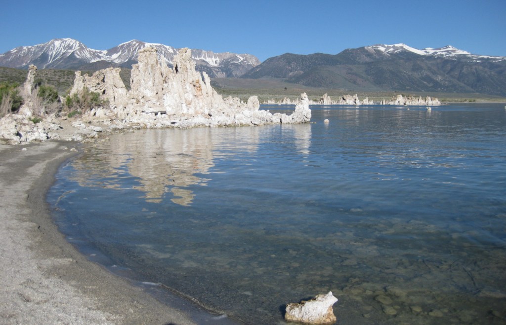
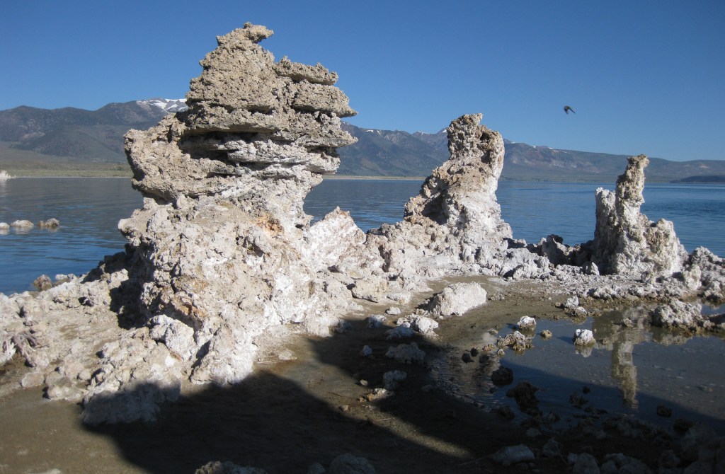
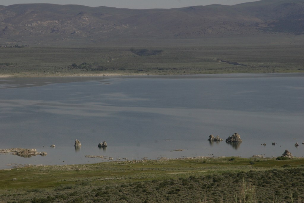
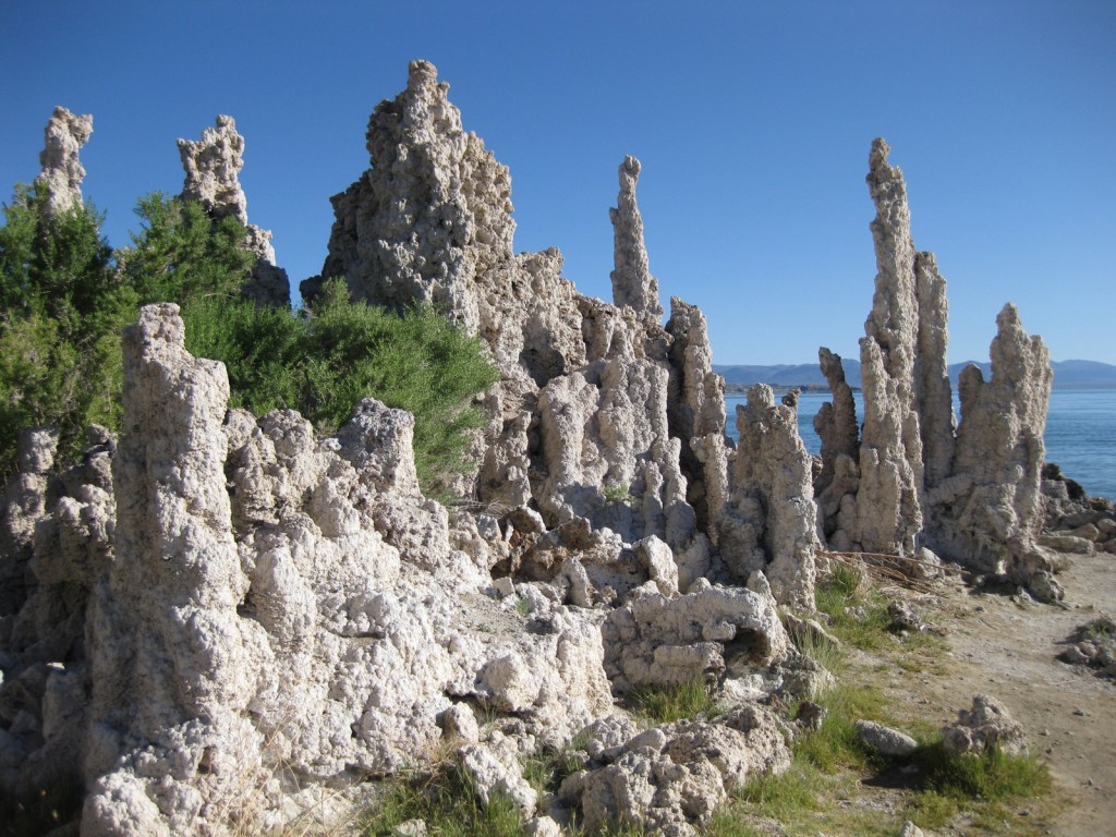
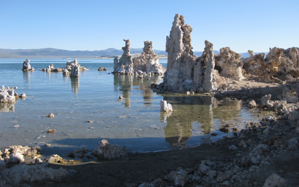
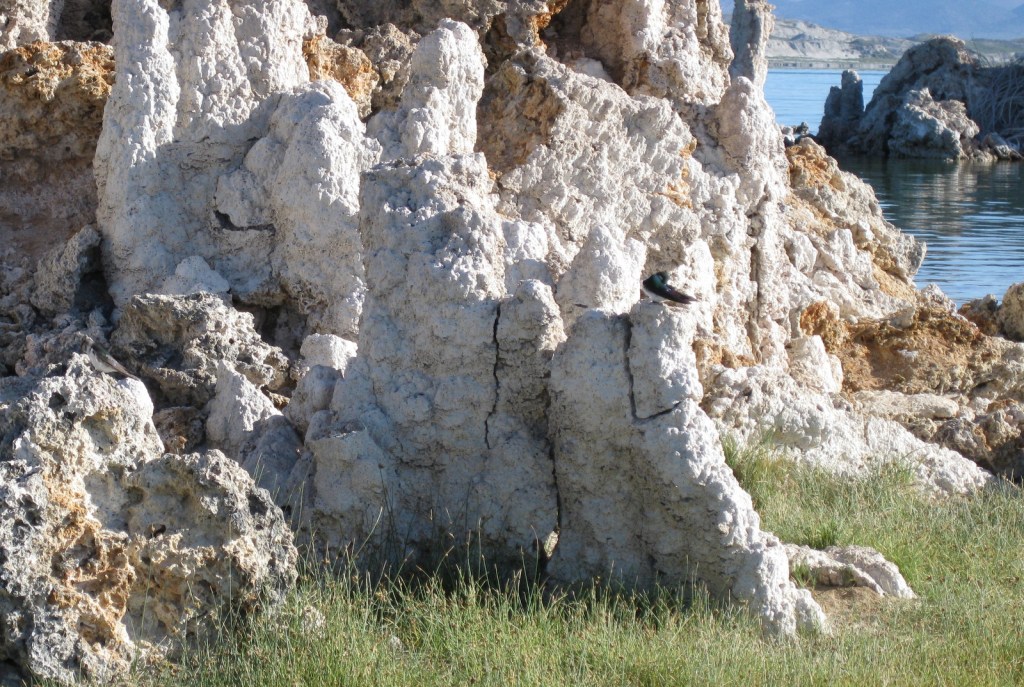
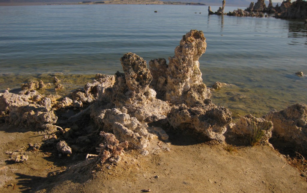
Established in 1984, this portion of Inyo National Forest is a geological wonderland that was once part of the former Mono National Forest.  Along the edge of this ancient salt lake are ten-foot-tall tufa towers exposed after water levels dropped beginning in 1941 when river water was diverted to Los Angeles.  Tufa is limestone that precipitated when the alkaline lake water combined with calcium from underground springs.  Paoha Island in the center of Mono Lake is also a nesting area for snowy plovers and California gulls, giving its salty waters even more of a Pacific Ocean impression.  This entire region is volcanically active as evidenced by isolated hot springs, cinder cones that erupted as recently as 350 years ago, and the forest devastation caused by a 1989 release of carbon dioxide from Horseshoe Lake.  It is also rich in minerals, showcased by the mines at Bodie State Historic Park, a ghost town conserved in “arrested decay.” 

Highlights

Mono Basin National Forest Scenic Area Visitor Center, film, Mono Lake Tufa State Natural Reserve, Panum Crater, Mono Craters, Bodie State Historic Park, South Tufa Trail

Must-Do Activity

Open May through October, the Mono Basin National Forest Scenic Area Visitor Center is located on Highway 395, just east of Tioga Pass (the eastern entrance to Yosemite National Park).  It features interactive displays on geology and human history, the 20-minute film Of Ice and Fire: A Portrait of the Mono Basin, photo exhibits, and a bookstore.  Situated atop a hill on the lake’s western shore, it offers an overlook of Mono Lake, Paoha Island, and the Mono Craters.

Best Trail

On the lake’s south side is the fascinating Mono Lake Tufa State Natural Reserve, established in 1981.  A short trail leads from the unpaved parking area to the shoreline.  Just to the west, the 0.7-mile Plug Trail enters the cone of Panum Crater, a 650-year-old plugged dome volcano.

Instagram-worthy Photo

The fragile tufa formations are a great resting place for violet-green swallows and other migratory birds that come to feed on the lake’s abundant brine shrimp and alkali flies.

Peak Season

Summer

Fees

$3 per person at South Tufa Trail or America the Beautiful pass; $8 per person to enter Bodie State Historic Park

Road Conditions

There are well-graded dirt roads to Panum Crater, South Tufa, and Bodie State Historic Park.  However, the routes on the north and east sides of Mono Lake are loose sand that require a four-wheel-drive vehicle.

Camping

There are campgrounds at June Lake and along Highway 120 to Tioga Pass, but that road is closed in the winter.  Dispersed camping is allowed in Inyo National Forest, but be careful on the sandy roads around Mono Lake.

Related Sites

Inyo National Forest (California-Nevada)

Manzanar National Historic Site (California)

Devils Postpile National Monument (California)

Death Valley National Park (California-Nevada)

Nearest National Park

Yosemite

Explore More – Most of the 27 Mono Craters are phreatic volcanoes that have been plugged or over-topped by rhyolite domes and lava flows; what does “phreatic” mean?

We Published Our Newest Travel Guidebook to America!

Today we published our newest guidebook to all 50 states available for sale on Amazon

50 States of Great: Road Trip Guide to America is a starting point for planning a road trip of any length, covering the best of each state in 12 categories: scenic drive, State Park, museum, waterfall, roadside attraction, National Forest, campsite, and more.  50 States of Great is a culmination of our extensive travels through the United States of America seeking out well-known destinations and less-frequented spots.  The goal of our book is to be useful whether you are taking a cross-country road trip or exploring your home state.

We are also giving a presentation on road tripping in the U.S.A. at the Laramie County Library in Cheyenne, Wyoming.  It will be held in the Cottonwood Room (1st floor) at 7 p.m. on Tuesday, December 5, 2023.  We will have all our books for sale before and after the talk and would be happy to sign them for you.

If you go to our book page on Amazon (https://amzn.to/3tZsK3K) click on the cover image to Look Inside.  We have included the Introduction below and will post a sample chapter on this website tomorrow.

Check out our Amazon author page and Shop tab for all four of our books, plus other products!

Introduction

We love traveling in the United States of America (U.S.). We have driven hundreds-of-thousands of miles across the country while on dozens of road trips, plus three flights taken to Hawai‘i. Utilizing our expertise, we wrote this guidebook with the goal of helping readers plan a road trip to see the best of what each state has to offer. This informative book presents all 50 states in alphabetical order, with abbreviated chapters at the end on American Samoa, the District of Columbia, Puerto Rico, and the U.S. Virgin Islands.

In our travels, we have visited every state—at least twice. We have spent the night in all 50 states. Between the two of us, we have lived in ten different states from coast to coast (Alaska, Arizona, Arkansas, California, Colorado, New York, North Carolina, Ohio, Tennessee, and Wyoming—our current home of more than a decade). We have visited in person more than 90% of the locations mentioned in this guidebook and we are excited to see some of the ones we learned about during our research, as well as making it to the remote territories of Guam and Northern Mariana Islands. As the old saying goes: “We have not been everywhere, but it is on our list.”

In 2016, we took ten months off to celebrate the centennial of the National Park Service (NPS) by visiting a State Park and an NPS site in all 50 states. Since then, we have traveled to all 50 states again and three territories, including a special trip in 2022 just to say we finally overnighted in Rhode Island. After the COVID-19 pandemic, we completed our effort to take a hike in all 155 National Forests and all 20 National Grasslands. We are currently on quests to hike in at least one National Wildlife Refuge in every single state (19 down) and finish visiting each state capital (only two to go).

We never liked the idea that parts of the U.S. are considered “flyover country,” and not just because we prefer to drive when we travel. This book started as a way to highlight the attractions in the central U.S., then we realized we knew just as many hidden gems in the most “touristy” states.  Relying on our first-hand knowledge, we selected a few must-see sites to visit in each of these 50 United States of America. [Historical note: It was not until the Civil War was fought to preserve the union in the 1860s that “these United States of America” began to be referred to as “the United States of America.”]

We created categories that focused on our areas of expertise, leaving hotels and restaurants to somebody better qualified to compare those businesses. Our categories became the headings for each state that are explained below.

Map

For each state we included an outline map with a star for the capital city and a triangle located at the high point.

Acreage

Not all states are equal in size, so we included the number of acres and the percentage of the U.S. that it covers.

Statehood

This is the year that state was admitted to the union and its number in sequence.

Capital

The city where the state capital resides is represented by a star on the map.

Population

Based on the 2020 census, we included total population and rank out of 50.

High Point

The name and elevation of the highest point in each state is listed, and its location is represented by a triangle on the map.

Name Origin

We briefly explain the often-mysterious etymology. Most state names come from the languages of American Indians, while others have European roots.

Nickname

Every state has a nickname (some of which have changed over time) and the origins of those names are sometimes convoluted.

Background

A catch-all heading that provides some history or glosses over the famous attractions to a particular state, like those in New York City or Las Vegas.

Must-Do Activity

The one place to make sure to visit if you are only going to do one thing in a given state. Our choices range from a city to walk around, an outdoor activity to do, or a general type of attraction to focus on, each of which is essential to experience the best of what that state has to offer.

Greatest National Forest

There are a few states with only one National Forest (and ten without any), which made the selection process easy, but others like California (with 19) were a real challenge to pick. For those ten states without, we chose a National Grassland, State Forest, or similar natural area. We gave equal space to all National Forests in our guidebook Out in the Woods: An Introductory Guide to America’s 155 National Forests.

National Parks

A simple list of each of the 63 National Parks that lie within that state’s border. For more information on each of these, check out our guidebook A Park to Yourself: Finding Adventure in America’s National Parks.

Best National Park Service Site

Excluding the 63 National Parks, we chose our favorite unit managed by the National Park Service from among the National Monuments, National Historic Sites, National Memorials, and other classifications.

Most Scenic Drive

States designate specific roads as “Scenic Byways,” but we did not limit our choices to the official ones. We have driven hundreds-of-thousands of miles on vacations, so we have a feel for what makes an interesting route.

#1 Roadside Attraction

There are entire websites dedicated to roadside attractions and we cannot claim to have been to even half of them. However, we try to break up our drives with interesting stops, some of which take longer to visit than others.

Unique Museum

There are thousands of museums across the U.S. covering art, science, history, and everything in between. We would not argue that these are necessarily the best museums in each state, only that they were unique enough to get our attention.

That’s So [State Name]

In our research, we came across patterns of similar attractions in a specific state or someplace exceptional that could exist only in one state. This became our catch-all heading for fun spots that did not seem to fit elsewhere.

Top State Park

All 50 states have State Parks and we have visited at least one in each state. We often highlight State Parks under other headings, but here we focus on one that stands out above the rest.

Favorite Short Hike

There are so many hiking trails and websites dedicated to them that it is often hard to choose a destination. We guarantee that if you take the trail we picked that you will get a good feel for that state.

Backpacking Destination

We love backpacking and have read more about these remote destinations than any other areas. Our experience on the East Coast is limited, but we did find at least a one-night excursion for all 50 states.

Cool Campsite

We have camped in nearly every state, but usually not in a campground. We prefer dispersed camping on public lands, like those run by the U.S. Forest Service and Bureau of Land Management. Here we focused on unique spots for pitching a tent that sometimes require boating, backpacking, or riding a train (see West Virigina).

Wonderful Waterfall

Waterfalls are some of the most popular destinations for hikes and drives. However, due to topography some states are more blessed with options than others. Our choice is not always the tallest or busiest, but we think you will not be disappointed if you go.

***

For trip planners, thick guidebooks can often be overwhelming and travel websites are usually more interested selling something than providing any useful information. Our research method usually starts with reading the short descriptions found in free tourist pamphlets or book series like Off the Beaten Path, and then further investigating those places on the internet. State Parks, National Forests, and National Park Service sites typically have useful information on their websites and apps. We apologize for any out-of-date content, as there may have been significant changes to some of the attractions since 2020. A wealth of data on specific destinations and hiking trails is available free online, often with detailed directions on how to get there. Check these frequently-updated websites first before visiting anywhere in our guidebook since they can close due to various economic and natural disasters.

For each state, we selected two original photographs by the authors from a place discussed in the headings above. We limited the number of photos from National Parks and National Forests as those can be found in our other guidebooks. You might notice our stuffed animal named Wondon in a few of the photos since he has his own travel blog (WondonBuns.blogspot.com).

All illustrations are original drawings by Scott based on photographs we have taken. We selected an animal found in each state to represent it, allowing for some duplicates. Scott’s illustrations from this book are available on a variety of products on our travel website (RavenAboutTheParks.com).

We hope that 50 States of Great provides inspiration for your own explorations of the United States of America.

Adventure on!

-Scott and Tiff

Cheyenne, Wyoming

October 2023

We are a participant in the Amazon Services LLC Associates Program, an affiliate advertising program designed to provide a means for us to earn fees by linking to Amazon.com and affiliated sites.

Continental Divide National Scenic Trail

Continental Divide National Scenic Trail

New Mexico, Colorado, Wyoming, Idaho, Montana

Managed by U.S. Forest Service (70%), Bureau of Land Management (12%), National Park Service (10%), other (8%)

Established 1978

3,028 miles

Website: https://www.fs.usda.gov/managing-land/trails/cdt

Overview

We decided to write about the Continental Divide National Scenic Trail (CDT) now, since Tiff recently finished backpacking the entire 512-mile Wyoming section of the route.  The CDT stretches 3,028 miles from the Crazy Cook Monument on the border with Mexico north to Waterton-Glacier International Peace Park.  The official trail is known as the “red route,” with popular alternatives called “blue routes” detouring through sections like New Mexico’s Gila Wilderness (which 95% of thru-hikers choose).  Tiff was supported by Scott along portions of the trail and they both backpacked through Yellowstone National Park together.  Tiff met dozens of thru-hikers doing the entire trail this year, many of whom were “flip-flopping” after getting stopped north bound (NOBO) by snowy Colorado mountains so switching to a south bound (SOBO) direction to finish.

Highlights

Rocky Mountain National Park, Yellowstone National Park, Glacier National Park, Gila Wilderness, El Malpaís National Monument, South Pass City State Park, Wind River Range, Lemhi Pass, Chinese Wall, Triple Divide Pass

Must-Do Activity

It takes the average thru-hiker 147 days to complete the trek (including “zeros days”), but you can get a feel for the experience on shorter point-to-point or loop hikes.  We have done the Rocky Mountain National Park section as a long day hike and Scott has backpacked the minimum 40 miles to see the famous Chinese Wall in Montana’s Lewis and Clark National Forest.  We had all three of our backcountry campsites to ourselves along Yellowstone National Park’s 67-mile stretch of CDT and went a full day without seeing another person near the park’s Idaho border.

Best Trail

The Wind River Range in Wyoming’s Bridger National Forest is probably the most scenic stretch of mountains on the entire CDT.  Many thru-hikers detour to a blue route to see beautiful, but overcrowded Titcomb Basin and the Cirque of the Towers (actually in neighboring Shoshone National Forest).  Read more about our 2020 trip (mostly) following the CDT 120 miles through the range in our newspaper article.

Instagram-worthy Photo

The CDT goes right past crowded Old Faithful in Yellowstone National Park’s Lower Geyser Basin, although there are other areas of colorful hot springs like those near Heart Lake (pictured).

Peak Season

Summer

Fees

Fees apply if you camp inside or drive into Rocky Mountain, Yellowstone, and Glacier National Parks

Road Conditions

Much of the trail is actually walking dirt roads and some paved roads, especially in New Mexico.  Access roads to certain trailheads can be very rough and require driving long unpaved sections, such as the 30 miles to busy Big Sandy Trailhead in Bridger National Forest.

Camping

Camping is dispersed except for designated sites (permit required) in Rocky Mountain, Yellowstone, and Glacier National Parks.

Related Sites

Appalachian National Scenic Trail (Georgia to Maine)

Pacific Crest National Scenic Trail (California-Oregon-Washington)

Natchez Trace National Scenic Trail (Mississippi-Alabama-Tennessee)

Explore More – Which three oceans receive water from Triple Divide Pass in Montana?

Top 10 States for State Parks

We are currently finishing up our newest travel guidebook 50 States of Great (for sale now on Amazon), which focuses on our favorite State Park, National Forest, Roadside Attraction, and nine other categories for every state in America.  Choosing one State Park for some states was easy, but others have so many great options it was a difficult decision.  We wanted to honor those states in this list, and we also included our favorite parks in each state (with the best named first).  Some of the listings are State Historic Sites that may be managed by a different government agency than State Parks or State Forests.  Click here to see all of our Top 10 Lists, including our Top 10 States for National Forests and Top 10 States for National Park Service sites.

10. South Dakota (view our 7-Day Road Trip Itinerary)

Custer (pictured), Bear Butte, Palisades, Newton Hills, Fort Sisseton

Custer State Park might be the only one on this list worthy of being a National Park for its iconic wildlife and historic architecture

9. Indiana (view our 7-Day Road Trip Itinerary)

Indiana Dunes, Spring Mill, Falls of the Ohio, Angel Mounds, Clifty Falls, O’Bannon Woods, Brown County

The best part of Indiana Dunes National Park might be Indiana Dunes State Park, plus you can buy some freshly ground cornmeal at Spring Mill

8. Montana

Lewis and Clark Caverns (pictured), Makoshika, Bannack, Pictograph Cave, Flathead Lake

A limestone show cave, badlands full of dinosaur fossils, and the ghost town that started the 1862 gold rush

7. Missouri

Elephant Rocks, Johnson’s Shut-Ins, Taum Sauk, Ha Ha Tonka, Route 66, Prairie, Montauk, Meramec

A fun mix of pretty hiking trails and interesting history can be found in Missouri

6. Nevada

Valley of Fire, Cathedral Gorge, Berlin-Ichthyosaur, Lake Tahoe Nevada

Geology is the highlight in these beautiful State Parks

5. North Carolina

Hammocks Beach, Chimney Rock, Jockey’s Ridge, Fort Macon, Stone Mountain, Fischer Point, Raven Rock, South Mountains, Hanging Rock, Pilot Mountain, Brunswick Town, Morrow Mountain, William B. Umstead

Entry is free to nearly every State Park here and we have visited 30+ in our former home state

4. Hawai‘i (view our 14-Day Trip Itinerary)

Waimea Canyon, Napali Coast (pictured), Kealakekua Bay, ‘Iao Valley, Diamond Head, Lava Trees, Akaka Falls, Koke‘e, Isaac Hale, Iolani Palace, Ahupuaa O Kahana

Incredible scenery is almost a given on the islands of this tropical paradise

3. Arkansas

Crater of Diamonds (pictured), Pinnacle Mountain, Petit Jean, Mt. Magazine, Mississippi River, Devil’s Den, Village Creek, Lake Chicot

The only publicly-owned diamond mine in the world is a major attraction in Arkansas

2. Utah

Goblin Valley, Coral Pink Sand Dunes, Kodachrome Basin, Antelope Island, Goosenecks, Dead Horse Point

Geology is the highlight in these beautiful State Parks

…and finally our #1 state for State Parks:

1. Texas

Caprock Canyons (pictured), Palo Duro Canyon, Resaca de la Palma, Big Bend Ranch, Monahans Sandhills, Davis Mountains, Enchanted Rock, Devil’s Sinkhole, Kickapoo Cavern, Old Tunnel, Brazos Bend, Caddo Mounds, Mission Tejas, San Jacinto Battleground, Pedernales Falls

A large, diverse state offers a wide variety of park experiences from evening bat flights to backcountry camping

.

Honorable Mentions

Virginia

False Cape, Grayson Highlands, Fairy Stone, First Landing, Douthat, Westmoreland

Backpacking on the beach in and the mountains, plus collecting fairy stones are highlights of our time in these (somewhat expensive) parks

California

Calaveras Big Trees (pictured), Pfeiffer Big Sur, Anza-Borrego Desert, Humboldt Redwoods, Moss Landing, Emerald Bay, Montaña de Oro, Mt. Tamalpais, Oceano Dunes, Fort Ross, Natural Bridges, Mt. Diablo

There have to be more State Parks here than anywhere else, some of which are amazing while others are not so great

Alabama

Cathedral Caverns, Rickwood Caverns, DeSoto, Cheaha, Fort Toulouse-Fort Jackson (pictured), Gulf, Joe Wheeler

Cave tours, waterfalls, and mountain views can all be found in diverse Alabama

Oregon

Silver Falls, Beverly Beach, Smith Rock, Farewell Bend, Fort Stevens, Jessie M. Honeyman, Sunset Bay, Seal Rock, Wallowa Lake, La Pine

From the ocean to the mountains and all in between

Georgia (view our 7-Day Road Trip Itinerary)

Providence Canyon (pictured), Stephen C. Foster, Tallulah Gorge, Cloudland Canyon, Fort Mountain

Forested slopes, steep cliffs, waterfalls, and the lowlands of the Okefenokee Swamp

Michigan

Mackinac Island, Porcupine Mountains, Hartwick Pines, Fort Wilkins, P.J. Hoffmaster, Straits

Mackinac Island State Park was once a National Park and the Porcupine Mountains offer an incredible wilderness for backpacking on Lake Superior

South Carolina

Huntington Beach, Edisto Beach, Colonial Dorchester, Myrtle Beach, Hunting Island, Table Rock, Hampton Plantation, Devil’s Fork, Mountain Bridge

Some of the best ocean side campgrounds in the United States

Davy Crockett National Forest

Davy Crockett National Forest

Texas

Managed by U.S. Forest Service, Southern Region

394,200 acres (160,647 federal/ 233,553 other)

Website: https://www.fs.usda.gov/texas

Overview

The pine forests and blackland prairies of Davy Crockett National Forest are situated between Lufkin and Crockett, Texas.  The National Forest is located within the Trinity and Neches River basins, where the Big Slough Canoe Trail explores the swampy 3,639-acre Big Slough Wilderness.  David Crockett was a frontiersman, soldier, and Tennessee politician who died at the infamous Battle of the Alamo in 1836 and later became an almost-mythical American folk hero known as the “King of the Wild Frontier.”  This swampy stretch of eastern Texas is a fitting place to be his namesake.

Highlights

Ratcliff Lake Recreation Area, Holly Bluff Campground, Neches Bluff Overlook, Neches River, Big Slough Canoe Trail, Tall River Trail, Four C Trail

Must-Do Activity

Davy Crockett National Forest’s most developed site is Ratcliff Lake Recreation Area, where several trails run near the campsites that surround the 45-acre lake, including one end of the 20-mile-long Four C National Recreation Trail.  The site also has a bathhouse, picnicking and swimming areas, and boat ramps.

Best Trail

The 20-mile Four C National Recreation Trail connects Ratcliff Lake Recreation Area with Neches Bluff Overlook, although hurricane damage closed the northern portion of the trail in 2019.  The trail is named after the Central Coal and Coke Company, which had a sawmill at Ratcliff Lake.  Much of the well-marked route follows abandoned tramways built by the company to haul logs.  The two trailheads are easily accessible from highways, but no backpack camping is allowed during deer hunting season (November through January).

Watchable Wildlife

Fishing is a major draw to Ratcliff Lake, as is hunting for white-tailed deer, fox squirrels, northern bobwhite quail, doves, wild turkeys, and various waterfowl.  Beavers and American alligators are also found at Ratcliff Lake.  Longleaf pine forests are managed to provide habitat for red-cockaded woodpeckers, an endangered species.  We saw an armadillo while hiking a swampy section of the Four C National Recreation Trail along the Neches River.

Instagram-worthy Photo

There is not much vertical topography in eastern Texas, so Neches Bluff Overlook stands out and commands an expansive view, including Caddo Mounds State Historic Site.

Peak Season

Spring and fall

Fees

None

Road Conditions

Access to Neches Bluff Overlook is by a well-maintained unpaved road that would be drivable by an RV.

Camping

There is free primitive camping allowed at Neches Bluff Overlook, which is located just south of Highway 21 near Caddo Mounds State Historic Site.  No backpack camping is allowed on the Four C National Recreation Trail during deer hunting season (November through January), when dispersed camping is also restricted to 20 designated hunter camps.

Wilderness Areas

Big Slough Wilderness

Related Sites

Angelina National Forest (Texas)

Sabine National Forest (Texas)

Big Thicket National Preserve (Texas)

Nearest National Park

Hot Springs

Conifer Tree Species

baldcypress, loblolly pine, shortleaf pine, longleaf pine, eastern redcedar

Flowering Tree Species

blackjack oak, post oak, southern red oak, white oak, swamp chestnut oak, willow oak, sweetgum, red maple, swamp red maple, green ash, swamp cottonwood, black willow, water hickory, pignut hickory, hophornbeam, sassafras, slippery elm, water elm, winged elm, American holly, yaupon holly, red buckeye, redbud, rough-leaf dogwood, flowering dogwood

Explore More – When were the mounds created at nearby Caddo Mounds State Historic Site?

Learn more about this and the 154 other National Forests in our new guidebook Out in the Woods

We are a participant in the Amazon Services LLC Associates Program, an affiliate advertising program designed to provide a means for us to earn fees by linking to Amazon.com and affiliated sites.