Tag Archives: geology

Apalachicola National Forest

Apalachicola National Forest

Florida

Managed by U.S. Forest Service, Southern Region

634,042 acres (563,403 federal/ 70,639 other)

Website: https://www.fs.usda.gov/main/florida/home

Overview

Apalachicola National Forest is the largest of the four National Forests in Florida and also manages the tiny 1,152-acre Choctawhatchee National Forest (which is off limits to the public on a military base, so we did not include it in our total of 155 National Forests).  The forests proximity to the state capital of Tallahassee makes it an outdoor recreation destination in the Florida Panhandle.

Highlights

Apalachee Savannahs Scenic Byway, Fort Gadsden Historic Site (closed), Ochlockonee River, Rock Bluff Scenic Area, Leon Sinks Geological Area (closed), Morrison Hammock Scenic Area, Silver Lake Recreation Area, Camel Lake Recreation Area, Post Office Bay, Florida National Scenic Trail

Must-Do Activity

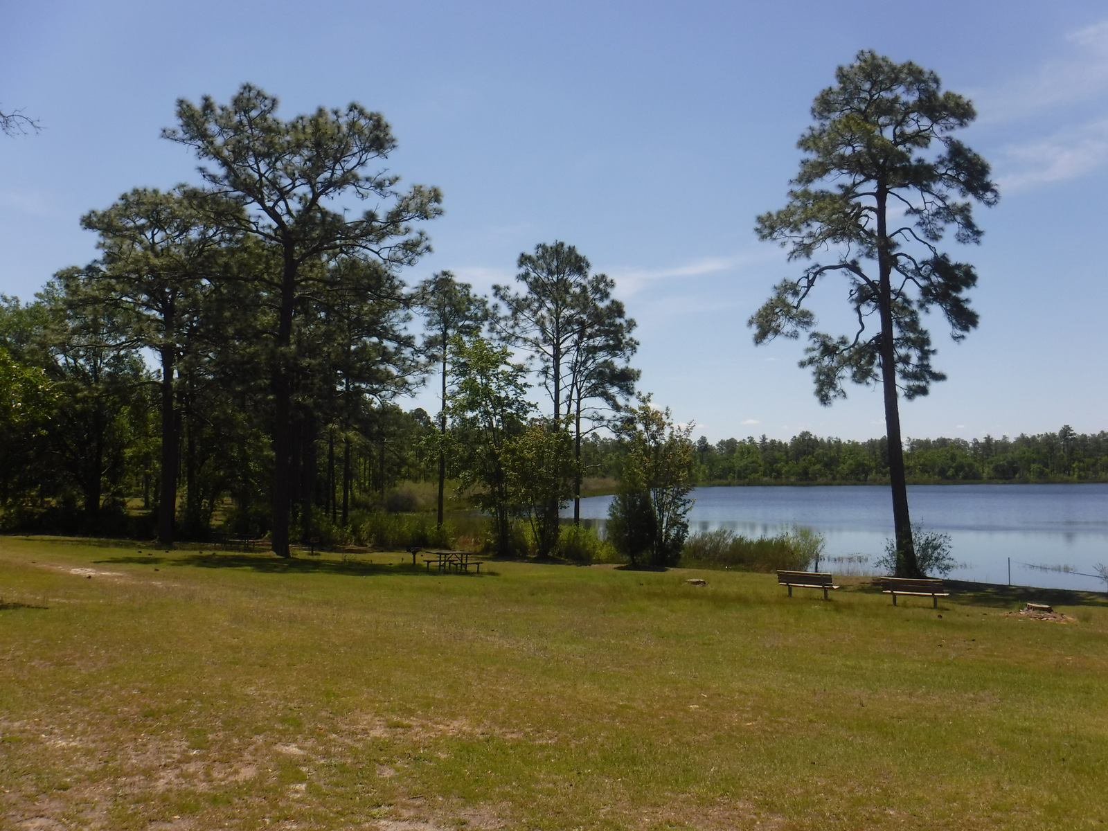
When we visited Apalachicola National Forest in April 2021, two of its biggest attractions were closed from hurricane damage: Fort Gadsden Historic Site and Leon Sinks Geological Area (a series of sinkholes in limestone karst).  We finally ended up at Camel Lake Recreation Area (day-use fee) where the beach was closed due to alligator presence, so we opted to hike a portion of the Florida National Scenic Trail.  We also made a stop to see the swamp at Big Gully Landing boat launch where Equaloxic Creek flows six miles west to the Apalachicola River.  We read that canoeing the Ochlockonee River is a popular activity.

Best Trail

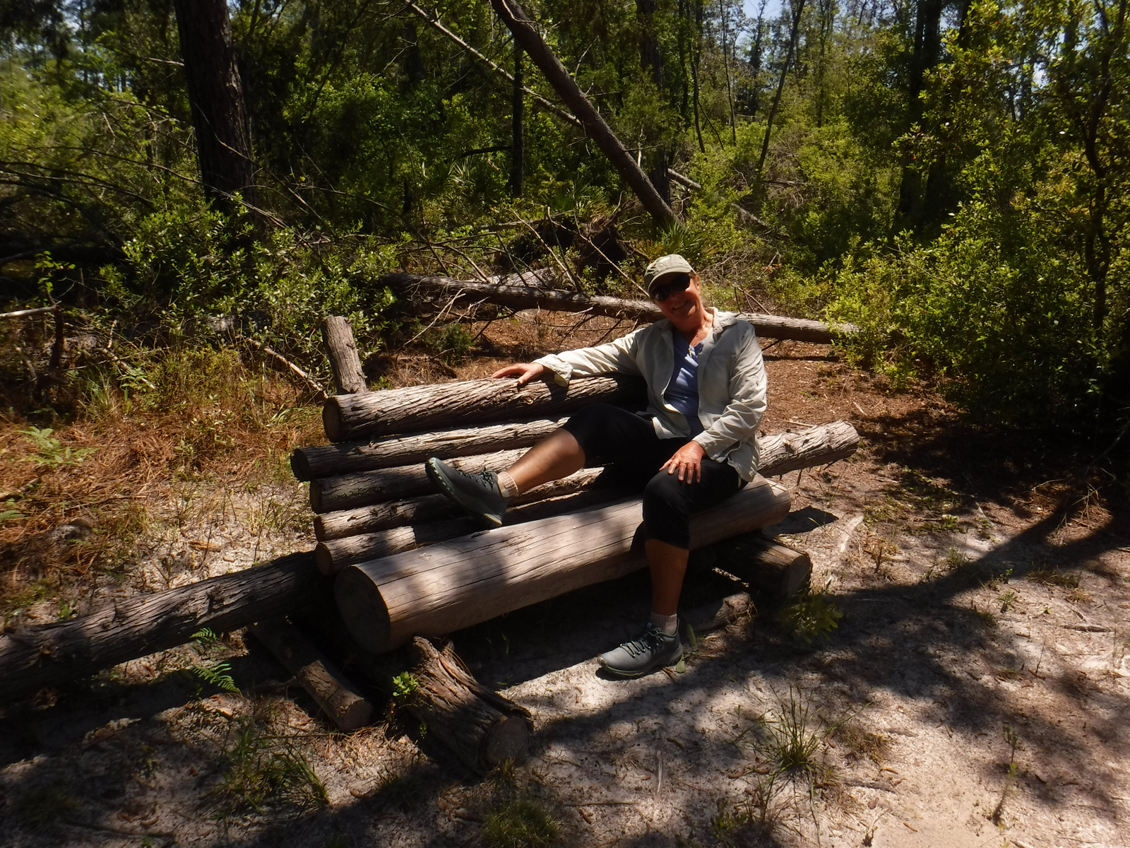
Apalachicola National Forest includes 67 miles of the Florida National Scenic Trail (FNST).  We hiked a portion of it at Camel Lake Recreation Area hoping to find where it connected to the Trail of Lakes nine-mile loop, but we never did locate the junction.  We read that the segment of the FNST from Oak Park Trailhead along the Sopchoppy River bluffs is especially beautiful.  Closer to the capital city, busy trails include the 14.4-mile Tallahassee Saint Marks Historic Rail Trail, 30-mile Vinzant Horse Trail, and 8.3-mile Munson Hills Trail (which is popular with mountain bikers).

Watchable Wildlife

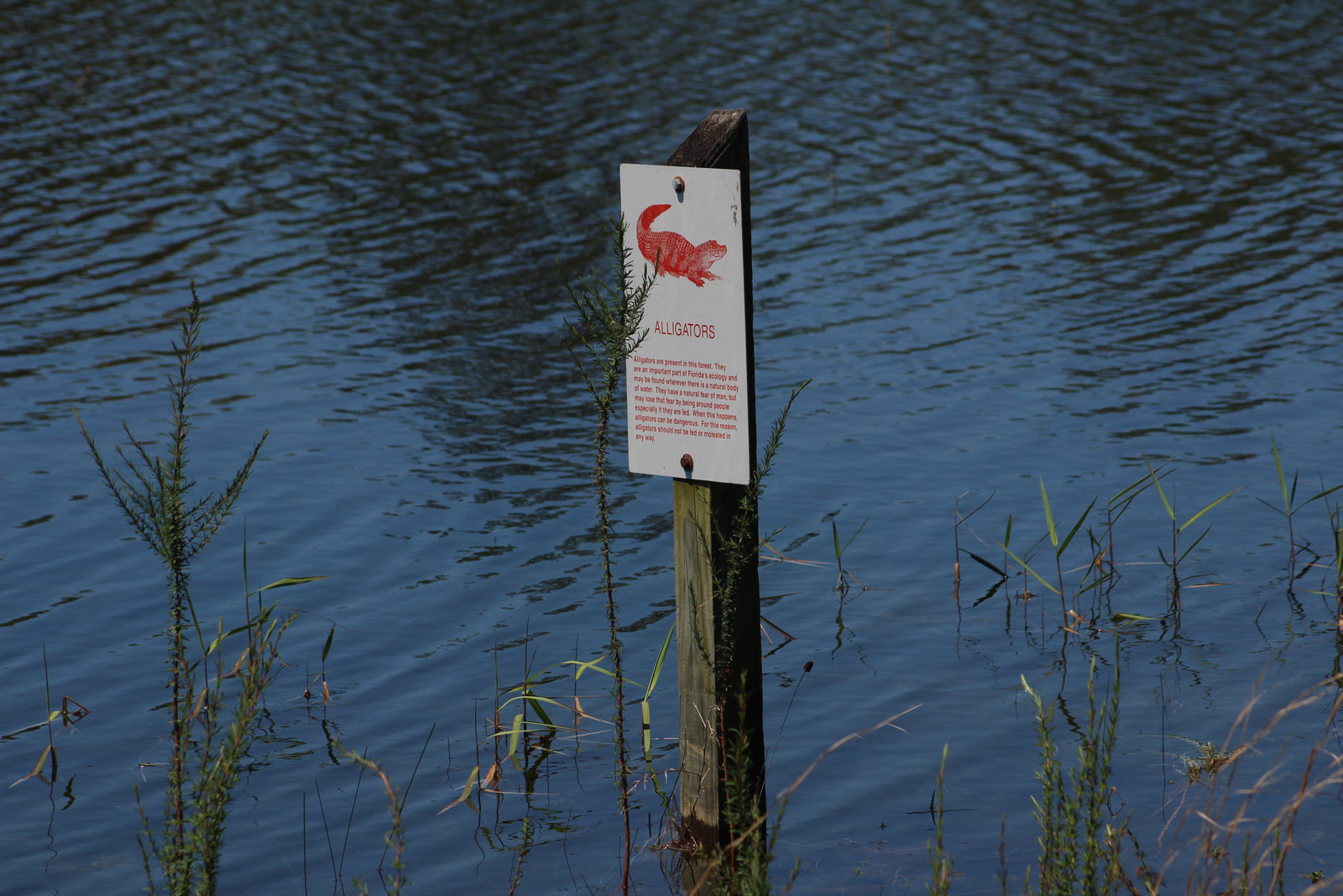
When we think of Florida wildlife the first animal that comes to mind is the alligator, so it was no surprise that the swimming beach at Camel Lake Recreation Area was closed due to their presence.  Other places to see alligators are Tate’s Hell Swamp and the Mud Swamp/New River Wilderness.  Cottonmouth snakes and plentiful mosquitoes also make the swamps uninviting to guests.  We were surprised to see signs warning of black bears since that is not an animal we associate with Florida.  Other wildlife includes turkeys, fox squirrels, gray foxes, bobcats, raccoons, and armadillos.

Instagram-worthy Photo

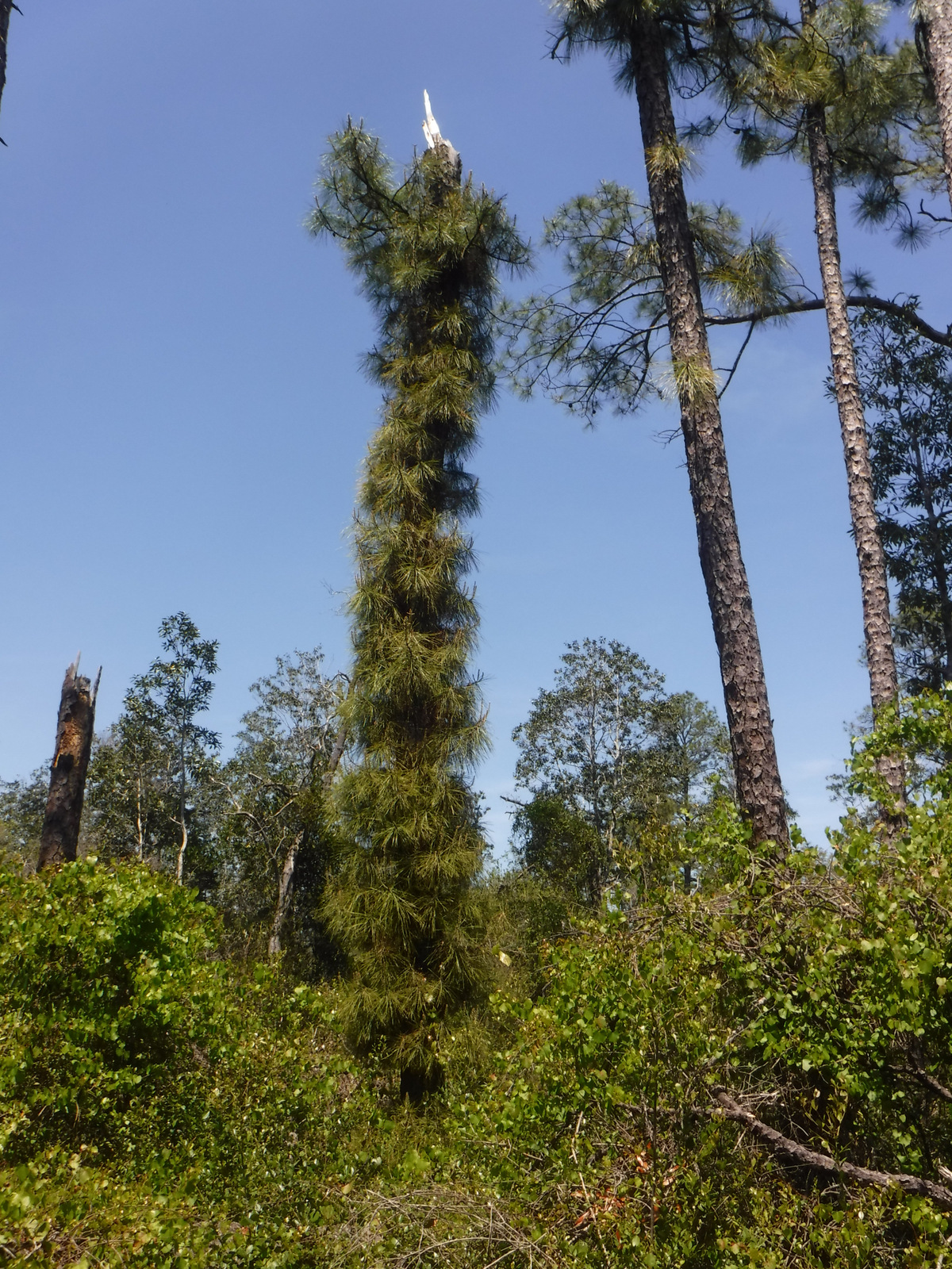
Stands of longleaf pine and turkey oak had us reminiscing about hiking the sandy trails on the coastal plains of North Carolina’s Croatan National Forest.

Peak Season

Winter

Fees

There was a day-use fee at Camel Lake Recreation Area, but it was half-off with an America the Beautiful pass.

Road Conditions

The unpaved roads were hard-packed sand, so they were in really good shape during our visit.

Camping

There was a nice 10-site campground (fee) suitable for RVs at Camel Lake Recreation Area, but there is no camping at Silver Lake Recreation Area closer to Tallahassee, Florida.

Wilderness Areas

Bradwell Bay Wilderness

Mud Swamp/New River Wilderness

Related Sites

Osceola National Forest (Florida)

Gulf Islands National Seashore (Florida)

Andersonville National Historic Site (Georgia)

Nearest National Park

Everglades (Florida)

Conifer Tree Species

baldcypress, pondcypress, longleaf pine, spruce pine, pond pine, slash pine, loblolly pine, Atlantic white-cedar

Flowering Tree Species

magnolia bay, sweetbay, black titi, myrtleleaf holly, swamp cyrilla, black cherry, sassafras, Darlington oak, southern red oak, live oak, bluejack oak, turkey oak, laurel oak, diamondleaf oak, mockernut hickory, pignut hickory, water hickory, persimmon, black gum, flowering dogwood, southern magnolia, basswood, American beech, sweetgum, ogeechee lime, swamp azalea, swamp cottonwood, pop ash, black willow, red buckeye, horse sugar tree

Explore More – Black titi is a shrub in this part of the world, but in Puerto Rico it grows as a large tree with what common name?

We are a participant in the Amazon Services LLC Associates Program, an affiliate advertising program designed to provide a means for us to earn fees by linking to Amazon.com and affiliated sites.

Crater Lake National Park

Overview

Formed by a cataclysmic volcanic eruption about 8,000 years ago, Crater Lake National Park protects a nearly round caldera about five miles in diameter.  It is the deepest lake in the country at 1,943 feet, which is a major reason why in 1902 it was named the sixth National Park in the U.S.  When we first visited back in July 2010 most of Rim Drive was still closed due to snow, but in July 2014 there was little snow to be found anywhere.

For Learn more in our guidebook to the National Parks, A Park to Yourself: Finding Adventure in America’s National Parks (available on Amazon).

Highlights

Rim Village, Cleetwood Trail, Cloudcap Overlook, Castle Crest Wildflower Trail, Mount Scott

Must-Do Activity

That very first view you get from the rim is so overwhelming that it is worth whatever effort you have to put in to arrive there.  Bring a coat, though, since at this high elevation we are pretty sure it can snow any month of the year.  Crater Lake has no inlets or outlets and its crystal-clear waters were fish free until some were introduced in the early 1900s.  The only way to get on the water is to hike down the steep one-mile Cleetwood Trail to a boat run by a park concessionaire.  Make sure you have purchased your ticket beforehand or you will be hiking back up to get one. 

Best Trail

We enjoyed the short but colorful Castle Crest Wildflower Trail, as well as the Pinnacles Overlook Trail where fossilized fumaroles mimic the conical shape of conifers.

Instagram-worthy Photo

Pictures truly do not do Crater Lake justice, but stop along Rim Drive to get a closer look at Wizard Island and the Phantom Ship, the only two islands that emerge from the lake.

Peak Season

Late summer

Hours

https://www.nps.gov/crla/planyourvisit/hours.htm

Fees

$30  per vehicle or America the Beautiful pass, but no entry fee in winter

Road Conditions

While some roads are closed most of the year, the National Park Service (NPS) plows the main entry road year round.  Bring your snowshoes!

Camping

The NPS manages two campgrounds in summer (although smaller Lost Creek only allows tent camping), or you can head to the neighboring National Forests for developed and dispersed campsites.

Related Sites

Oregon Caves National Monument and Preserve (Oregon)

John Day Fossil Beds National Monument (Oregon)

Mount Rainier National Park (Washington)

This design we created to celebrate Crater Lake National Park is available on a variety of products at Cafe Press and Amazon.

Explore More – What was the name of the vast volcano that existed here before it collapsed nearly 7,700 years ago?

We are a participant in the Amazon Services LLC Associates Program, an affiliate advertising program designed to provide a means for us to earn fees by linking to Amazon.com and affiliated sites.

Wupatki National Monument

Overview

In the open plateau northeast of Flagstaff, Arizona lies 35,000 acres set aside in 1924 to protect a collection of archaeological sites.  A 35-mile drive through Sunset Crater Volcano National Monument and adjacent Wupatki National Monument passes through ponderosa pine forests and sunflower-filled meadows on its way to an arid, rocky high desert.  Archaeologists theorize the Ancestral Puebloan people were attracted to this place by the fertile volcanic ash deposited by the contemporaneous eruptions at Sunset Crater. 

Highlights

Wupatki Pueblo, Lomaki Pueblo, Citadel and Nalakihu Pueblos, Wukoki Pueblo

Must-Do Activity

The most famous of the ruins is named Wupatki Pueblo, a three-story, 100-room house inhabited by Sinagua around AD 1100.  At the height of its occupation, the structure was three stories tall and contained 100 rooms.  Its location near a spring allowed villagers to farm the volcanically-enriched soil, plus the leisure to build an amphitheater and ball court.  Here there is more than just crumbling ruins and pottery shards behind glass in a museum; there is a palpable feeling that this was a place where people lived.

Best Trail

The paved walking loop from the visitor center at Wupatki Pueblo is a half mile long and there are short interpretive trails at several additional ruins (see Highlights above), most located not far from parking lots.

Instagram-worthy Photo

Next to the ball court, do not miss the small opening to a larger cavern (or earthcrack) that breathes in or out depending upon the change in barometric pressure.  It is not hard to imagine kids playing here hundreds of years ago.

Peak Season

Summer

Hours

https://www.nps.gov/wupa/planyourvisit/hours.htm

Fees

$25 per vehicle (or America the Beautiful pass), which also covers entrance to neighboring Sunset Crater Volcano National Monument

Road Conditions

All roads to ruins are paved, but there is one dirt road that leads to the Little Colorado River, which forms the border with the Navajo Indian Reservation.

Camping

The U.S. Forest Service runs the Bonito Campground across from the Sunset Crater visitor center between May and October.  Dispersed camping is allowed in portions of Coconino National Forest.

Related Sites

Walnut Canyon National Monument (Arizona)

Tuzigoot National Monument (Arizona)

Grand Canyon National Park (Arizona)

Explore More – What were the two main types of sedimentary rock used to construct the pueblos?

Lassen Volcanic National Park

Overview

Lassen Peak is the southernmost volcano in the Cascade Mountain Range that also includes Mount Rainier, Mount Saint Helens, and Mount Hood.  Lassen Peak last erupted from 1914 to 1917, prompting its creation as a National Park.  Access is limited during the long winters, but you can go cross-country skiing and snowmobiling in adjacent Lassen National Forest.

Learn more in our guidebook to the National Parks, A Park to Yourself: Finding Adventure in America’s National Parks (available on Amazon).

Highlights

Bumpass Hell, Lassen Peak Trail, Sulphur Works, Manzanita Lake

Must-Do Activity

Many hikers make it to the 10,457-foot summit of the dormant volcano for fantastic views of Lake Almanor and Mount Shasta.  If you are not up for a 2,000 foot elevation gain, then make sure to take the flatter trail to Bumpass Hell, a colorful collection of geysers, fumaroles, and hot springs that is like a miniature Yellowstone National Park.  June may be a little early to visit after heavy snow years, so aim for late-July or August instead.

Best Trail

In the park’s remote northeast corner, a hike to the well-named Painted Dunes is worth the effort.  From that point you can climb up the shifting trail to the top of the cinder cone for great views of the colorful lava bed, turquoise Butte Lake, and snow-covered Lassen Peak.  Expect to get a lot of jagged cinders in your shoes unless you come prepared.  If you continue your ramble you can hook up with the 2,663-mile long Pacific Crest Trail which cuts through the park.

Instagram-worthy Photo

There is a great view down into Bumpass Hell as you approach it from the trail.  Note the snowbanks lasting into late August.

Peak Season

Late summer

Hours

https://www.nps.gov/lavo/planyourvisit/hours.htm

Fees

$30 per vehicle or America the Beautiful pass

Road Conditions

Even if the paved road across the park’s high country is closed in early summer, try making it down the dirt road to Butte Lake (at a lower elevation) in the northeast corner of the park.

Camping

There are seasonal campgrounds within the park, or try finding a dispersed campsite on the dirt roads of surrounding Lassen National Forest.

Related Sites

Lava Beds National Monument (California)

Devils Postpile National Monument (California)

Whiskeytown-Shasta-Trinity National Recreation Area (California)

This design we created to celebrate Lassen Volcanic National Park is available on a variety of products at Cafe Press and Amazon.

Explore More – More than 400,000 year ago, much of the western half of the National Park was one large composite volcano estimated to have been 11 miles in diameter and how many feet in elevation?

We are a participant in the Amazon Services LLC Associates Program, an affiliate advertising program designed to provide a means for us to earn fees by linking to Amazon.com and affiliated sites.

El Malpais National Monument

Overview

Navajo legend states that during a battle on Mount Taylor, the Twin Gods struck off a giant’s head which became Cabezon Peak, its blood flowing southward, coagulating into the Malpais.  Meaning “the badland” in Spanish, this National Monument contains lava tubes and ice caves among its 114,000 rugged acres.  Easily accessible from Interstate 40, it does not take long before you feel like you are in the middle of nowhere watching beautiful patterns of cloud shadows drift slowly across the landscape.

Highlights

El Calderon lava tubes, Sandstone Bluffs Overlook, Zuni-Acoma Trail, La Ventana Natural Arch

Must-Do Activity

Be sure to take a hike to truly appreciate these lava flows, the most recent of which inundated agricultural fields of the Acoma people as recently as the 1400s.  Carefully stepping across the jagged rocks, we wondered if another cinder cone may be forthcoming to the region.  Geologists suggest that the volcanic activity in this area has ceased indefinitely, yet some of the eruptions here go back over a million years, making us wonder if it is only a temporary lull.  Be careful during the monsoon season, when giant cumulostratus clouds form in the wide-open blue sky foretelling afternoon thunderstorms. 

Best Trail

Lava tube caves are a major attraction to the park (and are sometimes closed), but before entering you must pick up a free permit to ensure you do not spread white-nosed bat syndrome.  El Calderon Area is easier to access than the rough road to Big Tubes Area, and in a 3.8-mile loop passes a cinder cone and bat cave, then enters a lava tube.  The Continental Divide National Scenic Trail and difficult 7.5-mile Zuni-Acoma Trail also traverse this mostly shadeless environment.

Instagram-worthy Photo

Take the short hike back to stand below towering La Ventana Natural Arch and enjoy the aroma of juniper wafting through the desert air.  It is technically in the Bureau of Land Management’s El Malpais National Conservation Area, not the neighboring National Monument run by the National Park Service.

Peak Season

Summer

Hours

https://www.nps.gov/elma/planyourvisit/hours.htm

Fees

None

Road Conditions

Most trailheads are off paved roads, but some roads in El Malpais National Monument require four-wheel drive (especially when wet), so check at a visitor center before setting out.

Camping

There are no developed campgrounds, but primitive camping is allowed on back roads and in the surrounding Cibola National Forest.  On Interstate 40, Bluewater Lake State Park has full RV hookups.  There is also a small campground located west down Highway 53 in El Morro National Monument.

Related Sites

Petroglyph National Monument (New Mexico)

Lava Beds National Monument (California)

Sunset Crater Volcano National Monument (Arizona)

Explore More – Privately owned and open for tourists, what makes nearby Bandera Crater special?