Tag Archives: hiking

Hovenweep National Monument

Overview

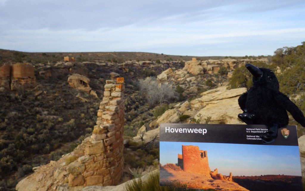
Partially surrounded by Canyons of the Ancients National Monument (run by the Bureau of Land Management), Hovenweep National Monument occupies a remote area on the southern Utah-Colorado border.  Established in 1923, it is composed of six units, the largest of which has a National Park Service (NPS) visitor center on the rim of Little Ruin Canyon, the location of the variable architectural styles of Square Tower Group. 

Highlights

Square Tower Group, Holly Group, Cajon Group, Hackberry Group, Cutthroat Castle Group

Must-Do Activity

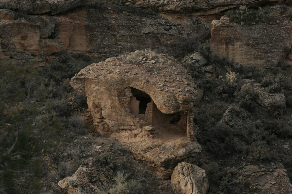
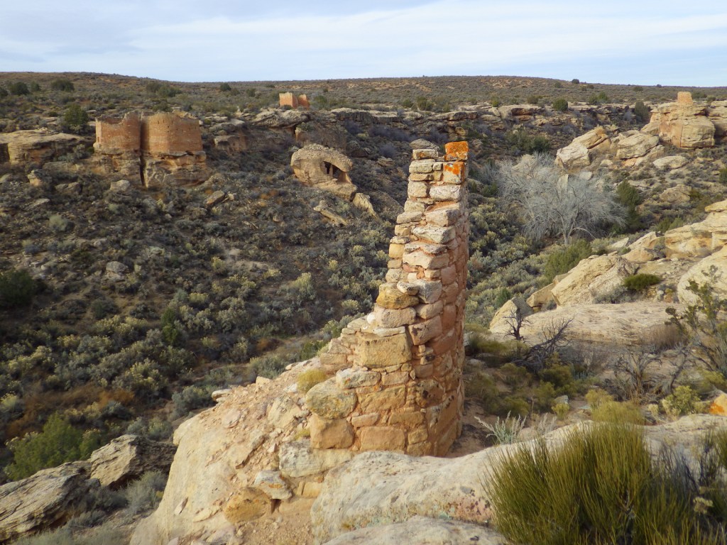
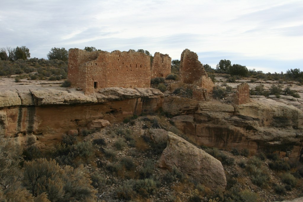
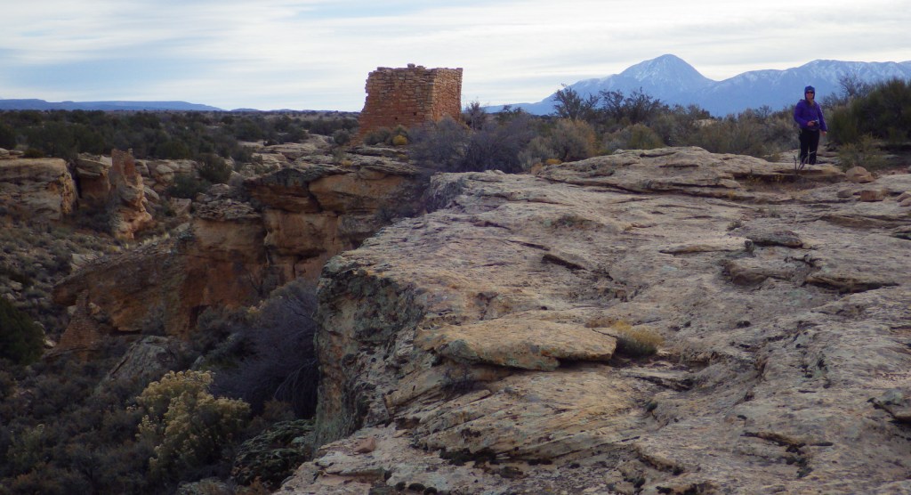
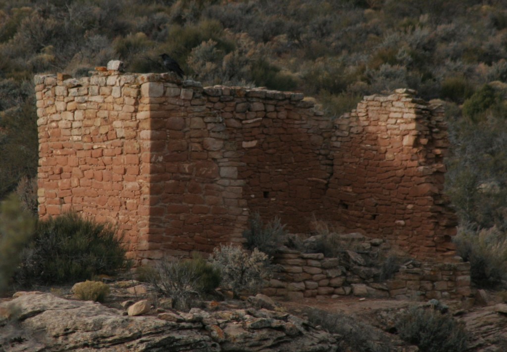
At Square Tower Group a two-mile loop hike takes visitors past an impressive collection of structures that date back to the 1200s, the same period that Ancestral Puebloans inhabited nearby Mesa Verde National Park.  The variety of building styles in this narrow canyon is remarkable, from Square Tower and Hovenweep Castle to Twin Towers and the unique Eroded Boulder House.  There is almost no shade to be found on the sagebrush plain of Cajon Mesa, so visiting in the heat of summer may not be as enjoyable.  The good news is that it makes for boundless vistas, especially to the south where Sleeping Ute Mountain looms.

Best Trail

The loop trail at Square Tower Group is paved and wheelchair accessible to the first overlook at Stronghold Point, but then gets much rougher over its two miles, especially at the end where it drops into Little Ruin Canyon.  A four-mile one-way trail connects this area to the Holly Group of ruins.

Instagram-worthy Photo

Little Ruin Canyon has one of the highest density collections of ruins anywhere in the southwest U.S., including the cool Eroded Boulder House, a part of the Square Tower Group.

Peak Season

Spring and fall

Hours

https://www.nps.gov/hove/planyourvisit/hours.htm

Fees

$20 per vehicle or America the Beautiful pass

Road Conditions

Despite its remote location, roads are paved to Square Tower Group, but accessing most of the other units requires driving or hiking rough dirt roads.  Further east in Colorado’s Canyons of the Ancients National Monument, visitors can drive well-maintained roads to the Escalante Ruins and Lowry Pueblo, as well as the two trailheads for Sand Canyon.

Camping

The NPS runs a 30-site campground (for a fee) at its visitor center near Square Tower Group.  Dispersed camping is allowed in many parts of Canyons of the Ancients National Monument.

Related Sites

Yucca House National Monument (Colorado)

Natural Bridges National Monument (Utah)

La Sal National Forest (Utah)

Nearest National Park

Canyonlands

Explore More – Hovenweep is a Ute-Paiute word that translates as what?

Cuyahoga Valley National Park

Overview

If you did not know there was a National Park in Ohio it is understandable since Cuyahoga Valley National Park was not officially designated until 2000.  It is centered around the historic Ohio and Erie Canal, which opened in 1827 to connect Akron to the port of Cleveland on Lake Erie.  Cuyahoga is an American Indian word meaning “crooked” and you will see why if you walk or bike down the 19-mile Towpath Trail where mules once pulled line boats through a series of locks (be sure to stop at Canal Visitor Center at Lock 38).  If you plan it right, you can take your bike on board the Cuyahoga Valley Scenic Railroad for a cheap one-way ride.

Learn more in our guidebook to the National Parks, A Park to Yourself: Finding Adventure in America’s National Parks (available on Amazon).

Highlights

Brandywine Falls, Lock 38, Hunt Farm, Everett Road Covered Bridge, Gorge Parkway

Must-Do Activity

In the park’s southern end near Akron-Canton, you will find a great blue heron rookery and beaver marsh along the crooked Cuyahoga River.  In the central section, you must stop to see the cascades of Brandywine Falls (see it depicted below in our original logo).  Closer to Cleveland, discover the Bedford Reservation along Gorge Parkway, including beautiful Bridal Veil Falls.  For a little culture in the outdoors, look up the summer schedule for Blossom Music Center or Porthouse Theatre.  Fall is an especially popular time to visit when the leaves change, but with over 100 miles of trails within the park, there is plenty to explore in every season.

Best Trail

We highly recommend a hike on the two-mile Ledges Loop Trail where mossy sandstone cliffs are cloaked by a dense forest of hemlock and hardwood trees.  Once a popular destination on the trail, Ice Box Cave is closed to protect the resident bat population, but similar spots nearby still offer a chance for exploration.

Instagram-worthy Photo

In the southern end of the park, Everett Road Covered Bridge has been rebuilt to demonstrate this once common construction method.

Peak Season

Fall

Hours

https://www.nps.gov/cuva/planyourvisit/hours.htm

Fees

None

Road Conditions

All roads paved

Camping

There is no official campground in the park, but there are a variety of other lodging options including the historic Inn at Brandywine Falls.

Related Sites

Allegheny Portage Railroad National Historic Site (Pennsylvania)

James A. Garfield National Historic Site (Ohio)

First Ladies National Historic Site (Ohio)

This design we created to celebrate Cuyahoga Valley National Park is available on a variety of products at Cafe Press and Amazon.

Explore More – Who manages the Hale Farm and Village where costumed re-enactors bring history to life?

We are a participant in the Amazon Services LLC Associates Program, an affiliate advertising program designed to provide a means for us to earn fees by linking to Amazon.com and affiliated sites.

Wupatki National Monument

Overview

In the open plateau northeast of Flagstaff, Arizona lies 35,000 acres set aside in 1924 to protect a collection of archaeological sites.  A 35-mile drive through Sunset Crater Volcano National Monument and adjacent Wupatki National Monument passes through ponderosa pine forests and sunflower-filled meadows on its way to an arid, rocky high desert.  Archaeologists theorize the Ancestral Puebloan people were attracted to this place by the fertile volcanic ash deposited by the contemporaneous eruptions at Sunset Crater. 

Highlights

Wupatki Pueblo, Lomaki Pueblo, Citadel and Nalakihu Pueblos, Wukoki Pueblo

Must-Do Activity

The most famous of the ruins is named Wupatki Pueblo, a three-story, 100-room house inhabited by Sinagua around AD 1100.  At the height of its occupation, the structure was three stories tall and contained 100 rooms.  Its location near a spring allowed villagers to farm the volcanically-enriched soil, plus the leisure to build an amphitheater and ball court.  Here there is more than just crumbling ruins and pottery shards behind glass in a museum; there is a palpable feeling that this was a place where people lived.

Best Trail

The paved walking loop from the visitor center at Wupatki Pueblo is a half mile long and there are short interpretive trails at several additional ruins (see Highlights above), most located not far from parking lots.

Instagram-worthy Photo

Next to the ball court, do not miss the small opening to a larger cavern (or earthcrack) that breathes in or out depending upon the change in barometric pressure.  It is not hard to imagine kids playing here hundreds of years ago.

Peak Season

Summer

Hours

https://www.nps.gov/wupa/planyourvisit/hours.htm

Fees

$25 per vehicle (or America the Beautiful pass), which also covers entrance to neighboring Sunset Crater Volcano National Monument

Road Conditions

All roads to ruins are paved, but there is one dirt road that leads to the Little Colorado River, which forms the border with the Navajo Indian Reservation.

Camping

The U.S. Forest Service runs the Bonito Campground across from the Sunset Crater visitor center between May and October.  Dispersed camping is allowed in portions of Coconino National Forest.

Related Sites

Walnut Canyon National Monument (Arizona)

Tuzigoot National Monument (Arizona)

Grand Canyon National Park (Arizona)

Explore More – What were the two main types of sedimentary rock used to construct the pueblos?

Ross Lake National Recreation Area

Overview

Bisecting the two sections of North Cascades National Park in northern Washington is Ross Lake National Recreation Area.  The incredibly scenic Highway 20 (closed seasonally) cuts through the mountains here, less than two hours from Seattle.  The rainshadow effect is readily apparent to anyone who crosses these mountains from the lush west to the arid eastern portion of the state.  Access to the only boat ramp on Ross Lake actually requires a drive through Canada, but you can also pick up a water taxi near Diablo Dam.

Highlights

Diablo Lake Overlook, Gorge Creek Falls, Ross Lake Resort, Sourdough Mountain Trail

Must-Do Activity

If coming from Seattle, start your visit at the North Cascades National Park Visitor Center on the scenic North Cascades Highway (20).  Ross Lake National Recreation Area contains three hydroelectric reservoirs, which have an interesting turquoise color due to glacial silt, especially evident at Diablo Lake Overlook.  Nearby, Colonial Creek Campground offers a peaceful forest in which to spend the night and a good jumping off place for a day hike on Thunder Creek or Fourth of July Trails through old-growth forests with colossal mushroom conchs and giant banana slugs.

Best Trail

Summiting Desolation Peak is often found on the bucket lists of the writer Jack Kerouac’s biggest fans, as he did some of his best writing while stationed as a fire lookout here in 1956.  The observation tower is not far from the Canadian border and the trek is a daunting task, typically utilizing a water taxi to cross Ross Lake.

Instagram-worthy Photo

Do not drive past Diablo Lake Overlook, an awe inspiring and usually gusty stop along Highway 20.  The craggy heights of the geologically young mountains surrounding this spectacular reservoir are magnificent to behold, yet forbidding to enter.

Peak Season

Late summer

Hours

https://www.nps.gov/noca/planyourvisit/hours.htm

Fees

None

Road Conditions

The North Cascades Highway (20) is typically closed east of Ross Dam from mid-November through mid-April (or later).  The unpaved road to Thornton Lakes Trailhead is not suitable for trailers.

Camping

Colonial Creek Campground (164 sites) is only one option, additionally there are Newhalem Creek (119 sites), Goodell Creek (22 sites), and Hozomeen (122 sites accessed via a 40-mile gravel road from Hope, British Columbia).  For the full backcountry experience, pick up a free backpacking permit at the Wilderness Information Center in Marblemount, Washington.

Related Sites

Lake Chelan National Recreation Area (Washington)

Lake Roosevelt National Recreation Area (Washington)

Klondike Gold Rush National Historical Park (Alaska-Washington)

Explore More – Only two miles across at its widest point, how long is Ross Lake?

Lassen Volcanic National Park

Overview

Lassen Peak is the southernmost volcano in the Cascade Mountain Range that also includes Mount Rainier, Mount Saint Helens, and Mount Hood.  Lassen Peak last erupted from 1914 to 1917, prompting its creation as a National Park.  Access is limited during the long winters, but you can go cross-country skiing and snowmobiling in adjacent Lassen National Forest.

Learn more in our guidebook to the National Parks, A Park to Yourself: Finding Adventure in America’s National Parks (available on Amazon).

Highlights

Bumpass Hell, Lassen Peak Trail, Sulphur Works, Manzanita Lake

Must-Do Activity

Many hikers make it to the 10,457-foot summit of the dormant volcano for fantastic views of Lake Almanor and Mount Shasta.  If you are not up for a 2,000 foot elevation gain, then make sure to take the flatter trail to Bumpass Hell, a colorful collection of geysers, fumaroles, and hot springs that is like a miniature Yellowstone National Park.  June may be a little early to visit after heavy snow years, so aim for late-July or August instead.

Best Trail

In the park’s remote northeast corner, a hike to the well-named Painted Dunes is worth the effort.  From that point you can climb up the shifting trail to the top of the cinder cone for great views of the colorful lava bed, turquoise Butte Lake, and snow-covered Lassen Peak.  Expect to get a lot of jagged cinders in your shoes unless you come prepared.  If you continue your ramble you can hook up with the 2,663-mile long Pacific Crest Trail which cuts through the park.

Instagram-worthy Photo

There is a great view down into Bumpass Hell as you approach it from the trail.  Note the snowbanks lasting into late August.

Peak Season

Late summer

Hours

https://www.nps.gov/lavo/planyourvisit/hours.htm

Fees

$30 per vehicle or America the Beautiful pass

Road Conditions

Even if the paved road across the park’s high country is closed in early summer, try making it down the dirt road to Butte Lake (at a lower elevation) in the northeast corner of the park.

Camping

There are seasonal campgrounds within the park, or try finding a dispersed campsite on the dirt roads of surrounding Lassen National Forest.

Related Sites

Lava Beds National Monument (California)

Devils Postpile National Monument (California)

Whiskeytown-Shasta-Trinity National Recreation Area (California)

This design we created to celebrate Lassen Volcanic National Park is available on a variety of products at Cafe Press and Amazon.

Explore More – More than 400,000 year ago, much of the western half of the National Park was one large composite volcano estimated to have been 11 miles in diameter and how many feet in elevation?

We are a participant in the Amazon Services LLC Associates Program, an affiliate advertising program designed to provide a means for us to earn fees by linking to Amazon.com and affiliated sites.