All posts by Raven About The Parks

Camp Nelson National Monument

Camp Nelson National Monument

Kentucky

Managed by National Park Service

Established 2018

525 acres

Website: nps.gov/cane

Overview

Camp Nelson National Monument occupies 525 acres where a Civil War fort was located 20 miles south of Lexington.  During the war, Kentucky was technically a Union state so the Emancipation Proclamation of 1863 did not apply to the state’s slaves.  Many local slaves were impressed by the U.S. Army to build the camp and their owners were compensated for the work.  In May 1864, when freedom was offered to any black man to join the United States Colored Troops, thousands of escaped slaves brought their families (who were not granted freedom) to this supply depot, which led to numerous conflicts between refugees and Army officials. 

Highlights

Museum, film, Oliver Perry House, barracks, Fort Putnam, Fort Jones, Home for Colored Refugees Site

Must-Do Activity

Unlike many new National Monuments, this one was already developed as the Camp Nelson Civil War Heritage Park so it has a historical museum, hiking trails, and interpretive film (that made our Top 10 list for NPS films).  The Oliver Perry House is the only original structure on site, although a barracks building and the earthworks of Fort Putnam have been reconstructed.  A living history weekend is typically held during the summer in the park, which is adjacent to Camp Nelson National Cemetery (see photos below) where hundreds of Civil War soldiers are buried.

Best Trail

There are four miles of trails in Fort Nelson National Monument with numerous interpretive signs and flags placed to identify the former locations of the bakery, prison, stables, Quartermaster Office, and other structures.  The Fort Jones/Overlook Trail accesses extensive stone revetment walls that provided defenses for the eastern side of Camp Nelson.  There is little shade in this grassy landscape, so come prepared on hot summer afternoons.

Instagram-worthy Photo

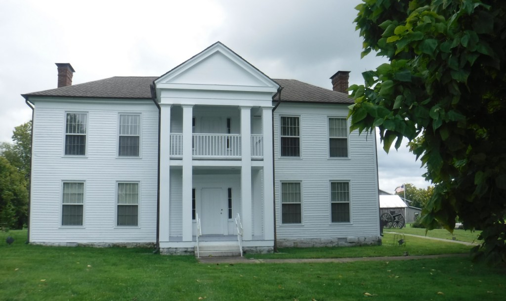
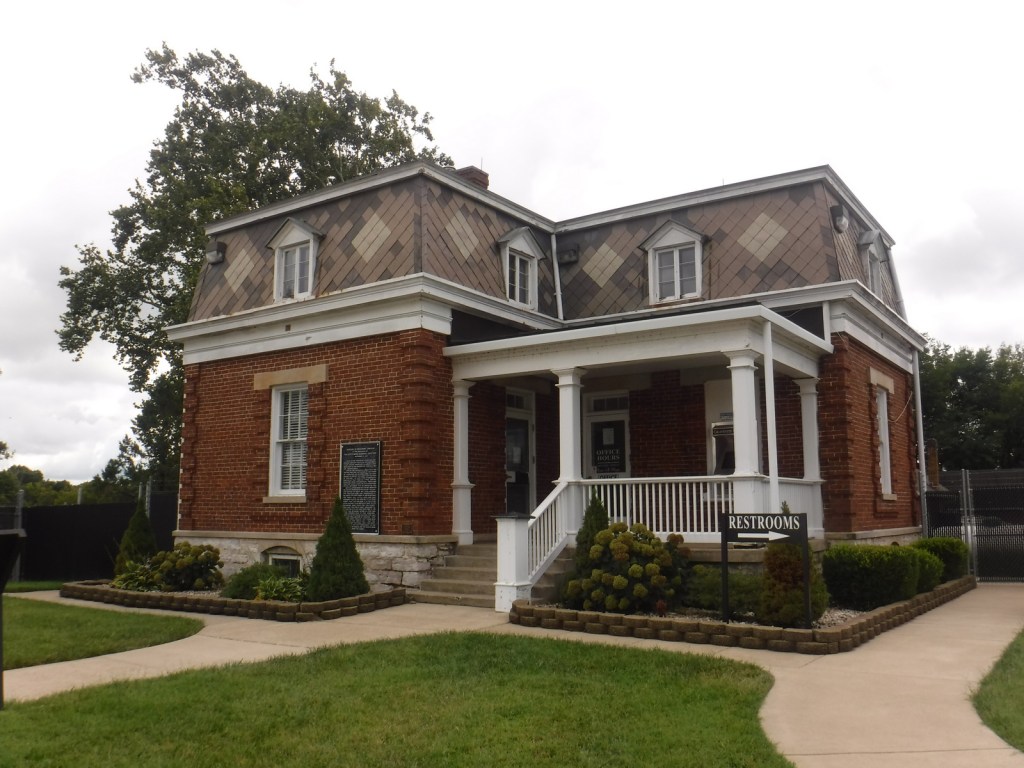
Built in 1846, the Oliver Perry House (also called the White House) is the only remaining original structure on site, which served as officers’ quarters.

Peak Season

Summer

Hours

https://www.nps.gov/cane/planyourvisit/hours.htm

Fees

None

Road Conditions

All roads paved

Camping

There is no campground on site, but there are some nice ones found throughout the Kentucky state parks system and Daniel Boone National Forest (where we recommend Cave Run Lake).

Related Sites

Daniel Boone National Forest (Kentucky)

Mill Springs Battlefield National Monument (Kentucky)

Mammoth Cave National Park (Kentucky)

Explore More – When was Army policy changed at Camp Nelson to allow the families of United States Colored Troops to have a mess hall, school, and housing?

Top 10 Films at National Park Service Visitor Centers

This fall we have driven all over the country and stopped at a handful of National Park Service (NPS) sites that we had never visited.  We have been surprised at the quality of the introductory films shown at some of these lesser-known spots, so we decided to put together a list of our all-time favorites.  Not every NPS site has a film, nor have we watched every one available at the 385 units we have visited, so there is a good bet we have missed some excellent ones.  Please let us know if you have a recommendation, as quite a few of the films are now available for free through the NPS app or on YouTube.  Click here to see all of our Top 10 lists, including some lists of movies not made by the NPS.

10. Fort Davis National Historic Site (Texas)

Basketball star Kareem Abdul-Jabbar in a cowboy hat is probably the best reason to watch this film about the “Buffalo Soldiers” (click to watch it on YouTube)

9. Moores Creek National Battlefield (North Carolina)

Reenactors in kilts holding swords make this seem more like Braveheart than the historically-accurate Revolutionary War scene that it is

8. Camp Nelson National Monument (Kentucky)

This recent addition to the NPS system has a great film about how a Civil War fort became a haven for runaway slaves

7. Big South Fork National River and Recreation Area (Tennessee-Kentucky)

Most of these films emphasize history, but this one focuses on the natural beauty and recreational opportunities in this forested wonderland

Scott with the 42′ x 377′ Cyclorama mural

6. Gettysburg National Military Park (Pennsylvania)

The only movie on this list that charges an admission fee, it is well-produced and pairs well with viewing the Cyclorama painting

5. Nez Perce National Historical Park (Idaho-Oregon-Washington-Montana)

The Nez Perce have a thriving nation as shown in this documentary that emphasizes the present more than the past (it plays at the visitor center in Spaulding, Idaho)

4. Stones River National Battlefield (Tennessee)

A short, modern film (on YouTube) that thoroughly and artfully explains the battle with long, uncut shots and realistic depictions of bullet wounds

3. Minidoka National Historic Site (Idaho)

New film covers the internment of 110,000 Japanese-Americans during World War II, not just the 13,000 imprisoned in central Idaho

2. Eleanor Roosevelt National Historic Site (New York)

The excellent documentary Close To Home (on YouTube) focuses primarily on the former First Lady’s inspirational career after her time in the White House

…and finally our #1 film at a National Park Service visitor center:

1. Minute Man National Historical Park (Massachusetts)

Multiple screens with props in the foreground make for an unforgettable telling of Paul Revere’s ride at the visitor center in Lexington

.

Honorable Mentions

Hopewell Culture National Historical Park (Ohio)

This film is less than six minutes long, but it is very informative and available on YouTube

Frederick Douglass National Historic Site (District of Columbia)

This film is very dated to the 1970s, so it is unintentionally funny while still being informative

President William Jefferson Clinton Birthplace National Historic Site (Arkansas)

Interviews with the former President highlight this retelling of his childhood in the small town of Hope where he was born to a widowed mother under the name Billy Blythe III

Pu’uhonua O Hōnaunau National Historical Park (Hawai’i)

We did not watch the whole film, but this must be the most pleasant theater in the NPS system

Independence National Historical Park (Pennsylvania)

There are actually two films shown at the visitor center in downtown Philadelphia, but only one stars a young Kristen Bell (from Veronica Mars and Disney’s Frozen)

Custer National Forest

Custer National Forest

Montana, South Dakota

Managed by U.S. Forest Service, Northern Region

1,278,749 acres (1,188,130 federal/ 90,619 other)

Website: https://www.fs.usda.gov/custergallatin

Overview

Custer National Forest is split across multiple units from the Absaroka Mountains in southern Montana east to five isolated patches in the northwest corner of South Dakota.  It ranges in elevation from dry prairies to glaciated summits, including the highest point in Montana (12,807-foot Granite Peak).  In eastern Montana, Capitol Rock is a sandstone and white clay formation that looks like a capitol dome from the east.  In South Dakota, the National Forest also encompasses The Castles National Natural Landmark.  Since 2014, Custer and Gallatin National Forests have been managed together as Custer-Gallatin National Forest.

Highlights

Beartooth All-American Road, Rock Creek Vista, Hellroaring Plateau, Granite Peak, East Rosebud Lake, Impasse Falls, Crooked Creek Canyon, Big Ice Cave, Pryor Mountains Wild Horse Range, Lost Water Canyon, Cook Mountains, Tongue River Breaks, Poker Jim Lookout, Chalk Buttes, Capitol Rock, Slim Buttes, The Castles, Glacier Lake, Basin Creek National Recreation Trail, Basin Lakes Trail

Must-Do Activity

Custer National Forest is most famous for its stretch of Highway 212 (Beartooth All-American Road) that climbs switchbacks from the prairie around Red Lodge, Montana up to 10,947 feet at Beartooth Pass across the Wyoming border in Shoshone National Forest.  These two National Forests also share with Gallatin National Forest the giant 943,626-acre Absaroka-Beartooth Wilderness, which contains 12,807-foot Granite Peak.  Backpackers come from around the world to this Wilderness in the summer because its trailheads start at such high elevations that it does not require much climbing to reach scenic alpine lakes.

Best Trail

There are more than 1,500 miles of hiking trails in Custer National Forest, mostly concentrated in the western mountains.  From the Glacier Lake Trailhead (high-clearance vehicle required), the two-mile Glacier Lake Trail steadily climbs 1,100 feet then drops into a bowl containing a stunning reservoir that straddles the Wyoming-Montana state border.  You can turn around here at 9,691 feet in elevation or continue around the north side of the lake up to Goat and Sheep Lakes.  We backpack camped at Glacier Lake for one night during Labor Day weekend and had the place to ourselves.

Watchable Wildlife

In addition to the raptors typical of western National Forests, merlins (a type of small falcon) are more common here than anywhere else in the country.  Mammalian predators include grizzly bears, black bears, gray wolves, coyotes, red foxes, pine martens, mountain lions, and bobcats.  Ungulates found here are pronghorns, moose, mountain goats, bighorn sheep, mule deer, elk, and bison (on private ranches).

Instagram-worthy Photo

During our backpacking trip, the Glacier Lake reservoir was especially scenic during the jaw-dropping twilight hours when the mountains were drenched in alpenglow.

Peak Season

Summer

Fees

None

Road Conditions

The paved Beartooth All-American Road (Highway 212) is typically open only June to October due to snow.  At the bottom of the “Beartooth Switchbacks” on Highway 212 in southern Montana is Main Fork Rock Creek Road, a rough dirt road that follows the shallow creek past campgrounds and dispersed campsites back to Glacier Lake Trailhead.  A high-clearance vehicle or an ATV is required if you want to drive the entire eight miles.  Many recreationists bring the latter to tackle the nearby road that steeply ascends to the top of 11,000-foot-high Hellroaring Plateau.

Camping

There are more than 30 campgrounds in Custer National Forest, as well as numerous dispersed camping options (especially on roads west of Red Lodge, Montana).

Wilderness Areas

Absaroka-Beartooth Wilderness (also in Gallatin and Shoshone National Forests)

Related Sites

Bighorn Canyon National Recreation Area (Montana-Wyoming)

Little Bighorn Battlefield National Monument (Montana)

Beaverhead National Forest (Montana)

Nearest National Park

Yellowstone

Conifer Tree Species

Douglas-fir, ponderosa pine, lodgepole pine, limber pine, whitebark pine, Engelmann spruce, subalpine fir, Rocky Mountain juniper

Flowering Tree Species

eastern cottonwood, quaking aspen, water birch, Rocky Mountain maple, boxelder, Bebb willow, blue elderberry, choke cherry, white alder, curlleaf mountain-mahogany, sagebrush

Explore More – Found on the side of Granite Peak, how did Grasshopper Glacier get its name?

Learn more about this and the 154 other National Forests in our new guidebook Out in the Woods

We are a participant in the Amazon Services LLC Associates Program, an affiliate advertising program designed to provide a means for us to earn fees by linking to Amazon.com and affiliated sites.

Croatan National Forest

Croatan National Forest

North Carolina

Managed by U.S. Forest Service, Southern Region

308,234 acres (159,885 federal/ 148,349 other)

Website: https://www.fs.usda.gov/nfsnc

Overview

The sandy soil of North Carolina’s coastal plain is where you will find Croatan National Forest, the land of the longleaf pine (which is the official state tree).  Longleaf pines are adapted to frequent surface fires by going through a “grass stage” when young, so the Forest Service conducts controlled burns in some stands.  Much of the National Forest has standing water (in pocosins and Carolina bays), which is why there is not a single trail through its 31,000 acres of designated Wilderness areas.  Pocosins are raised bogs and home to 11 species of carnivorous plants, including the federally-protected Venus flytrap.  A Carolina bay is one of many oval-shaped depressions typically filled with water that are oriented in a northwest-southeast direction across the coastal plain.  They range in size from small ponds to two miles in diameter, but the exact cause of their formation is unknown.

Highlights

Cedar Point Tideland National Recreation Trail, Flanner Beach, Fishers Landing, Brice Creek canoe trail, Black Swamp OHV Trail, Island Creek Trail, Patsy Pond Nature Trail, Cedar Point Tideland National Recreation Trail, Neusiok Trail

Must-Do Activity

To find some of the 11 species of carnivorous plants in Croatan National Forest, you will have to work a little bit.  Pull off one of the highways that bisect the area and hike to the edge of a pocosin, where scrubby vegetation grows in highly-acidic black soil.  Pitcher plants, bladderworts, sundews, and Venus flytraps utilize different methods to capture insects and spiders in order to sap their nitrogen and other nutrients that are scarce in the water-logged soil.  To trigger a tiny Venus flytrap to close, an insect must touch one hair twice or multiple hairs within 20 seconds.  They are often found adjacent to larger pitcher plants, which lure insects inside by color or odor, then are too slick-walled to escape.  Sundews and the butterwort utilize a sticky substance to capture their prey.  The five species of bladderworts float in shallow water where they capture swimming prey that trigger a trap door.

Best Trail

The Cedar Point Tideland National Recreation Trail is a 1.4-mile loop located partially on a boardwalk near the mouth of the White Oak River.  There are also two long trails through the swamps and pine forests: Neusiok Trail (21 miles) and Weetock Trail (14 miles).  There are no designated trails through Croatan National Forest’s 31,000 acres of designated Wilderness areas. 

Watchable Wildlife

Black bears in this region can get very big since they generally do not hibernate in the winter.  Other large mammals found are bobcats, raccoons, river otters, and muskrats.  Great blue herons, snowy egrets, ospreys, bald eagles, peregrine falcons, wild turkeys, woodcocks, and northern bobwhite quail are major bird species.  There are a variety of reptiles and amphibians, including alligators, anoles, cottonmouths, copperheads, canebrake rattlesnakes, pigmy rattlesnakes, and eastern diamondback rattlesnakes.  The tannic-stained blackwater supports fish like warmouth, redfin pickerel, sunfish, bowfin, yellow bullhead catfish, and the rare swampfish (a species of cavefish). 

Instagram-worthy Photo

Carnivorous pitcher plants have large showy flowers that bloom in early May.

Peak Season

Spring and fall

Fees

None

Road Conditions

The major highways (17, 58, 70) that cross the National Forest are paved, and the sandy, unpaved roads are generally in good shape except when flooded.

Camping

There are Forest Service campgrounds at Flanner Beach on the Neuse River and Cedar Point along the White Oak River.

Wilderness Areas

Catfish Lake South Wilderness

Pocosin Wilderness

Pond Pine Wilderness

Sheep Ridge Wilderness

Related Sites

Cape Lookout National Seashore (North Carolina)

Fort Raleigh National Historic Site (North Carolina)

Moores Creek National Battlefield (North Carolina)

Nearest National Park

Congaree

Conifer Tree Species

baldcypress, longleaf pine, loblolly pine, shortleaf pine, pond pine, eastern redcedar, Atlantic white-cedar

Flowering Tree Species

black gum, umbrella magnolia, southern magnolia, northern red oak, southern red oak, white oak, water oak, chestnut oak, overcup oak, black cherry, sassafras, American holly, yaupon holly, Hercules’ club, sweetgum, red maple, sugar maple, white alder, witch hazel, American beech, black walnut, tulip-poplar, hophornbeam, musclewood, red mulberry, flowering dogwood, loblolly bay, red bay, sweet bay magnolia, titi

Explore More – What is the origin of the National Forest’s name and how does it relate to Fort Raleigh National Historic Site?

Learn more about this and the 154 other National Forests in our new guidebook Out in the Woods

We are a participant in the Amazon Services LLC Associates Program, an affiliate advertising program designed to provide a means for us to earn fees by linking to Amazon.com and affiliated sites.

Coronado National Forest

Coronado National Forest

Arizona

Managed by U.S. Forest Service, Southwestern Region

1,859,807 acres (1,786,620 federal/ 73,187 other)

Website: https://www.fs.usda.gov/coronado

Overview

Coronado National Forest is sprinkled across the southeastern Arizona landscape, encompassing many forested “sky islands” that rise above the surrounding Sonoran Desert.  The isolation of these ranges has led to the evolution of some endemic species of plants and animals unique to this region.  That isolation also allows for clear night skies, so there are several peaks with astronomical observatories.  The most visited portion of the forest is the Santa Catalina Mountains, easily accessible along the paved 35-mile-long Catalina Highway east of Tucson, Arizona. 

Highlights

Catalina Highway, Sabino Canyon Recreation Area, Mt. Lemmon, Windy Point, Madera Canyon, Sky Island Scenic Byway, Mt. Graham, Onyx Cave, Madera Canyon, Mt. Hopkins Observatory, Pena Blanca Lake, Ramsey Canyon, Miller Peak, Cochise Stronghold

Must-Do Activity

The Santa Catalina Mountains offer many recreational opportunities, from road biking to downhill skiing at the top of 9,157-foot Mt. Lemmon (the southernmost ski area in the U.S.).   The scenic beauty and expansive vistas along the Catalina Highway are worth the many switchbacks, and you might drive past some of the most famous triathletes in the world who train here in the winter.  The drive ascends through multiple life zones from saguaro-dotted desert to ponderosa pine forest.  At the base of the Santa Catalina Mountains is the busy Sabino Canyon Recreation Area (fee).

Best Trail

Box Camp Trail is special to us as it was the site of our first date, marriage proposal, and wedding ceremony.  Over the course of 13 miles, Box Camp Trail drops 5,000 feet in elevation from ponderosa pine forest through pinyon-juniper woodland to the desert of Sabino Canyon dominated by saguaro cacti.  The rugged trail disappears in places, but offers incredible views along the way.  Route finding is required as the trail is somewhat overgrown (with downed trees from wildfires), plus the one-way hike requires two cars, one left at Sabino Canyon Recreation Area and one at the trailhead on the Catalina Highway. 

Watchable Wildlife

The Sonoran Desert is home to numerous unique wildlife species from roadrunners to Coues white-tailed deer.  Many of the animals are nocturnal to avoid the heat of the day, including ringtails (or ring-tailed cats), kangaroo rats, and javelinas (or collared peccaries).  The “sky islands” provide habitat for black bears, coyotes, skunks, mountain lions, bobcats, pronghorns, mule deer, and elk.  Sabino Canyon Recreation Area is known for its coatis, relatives of raccoons that typically travel in packs.

Instagram-worthy Photo

Windy Point is a spectacular overlook along the Catalina Highway in the pinyon-juniper woodland zone.  Not a bad spot for wedding photos, if we do say so ourselves.

Peak Season

Spring and fall

Fees

There is a fee to park at Sabino Canyon Recreation Area, plus a charge for the tram ride. Check the USFS website for details.

Road Conditions

The paved Catalina Highway is sometimes closed due to snow and ice in the winter.  There are some rough roads in this part of the Sonoran Desert, and especially be aware of the potential for flash flooding.

Camping

There are designated campgrounds along the Catalina Highway and throughout Coronado National Forest.  We dispersed camped near Dragoon Springs Station south of Interstate 10, but the access roads were in bad shape.

Wilderness Areas

Chiricahua Wilderness

Galiuro Wilderness

Miller Peak Wilderness

Mount Wrightson Wilderness

Pajarita Wilderness

Pusch Ridge Wilderness

Rincon Wilderness

Santa Teresa Wilderness

Related Sites

Coronado National Memorial (Arizona)

Tumacácori National Historical Park (Arizona)

Chiricahua National Monument (Arizona)

Nearest National Park

Saguaro

Conifer Tree Species

two-needle pinyon pine, alligator juniper, ponderosa pine, Chihuahua pine, Apache pine

Flowering Tree Species

Emory oak, Arizona oak, Mexican blue oak, Arizona rosewood, black alder, Arizona walnut, velvet ash, Arizona sycamore, quaking aspen

Explore More – Who was the famous ecologist that studied the similarity of increasing elevation to increasing latitude more than a century ago in the Santa Catalina Mountains?

Learn more about this and the 154 other National Forests in our new guidebook Out in the Woods

We are a participant in the Amazon Services LLC Associates Program, an affiliate advertising program designed to provide a means for us to earn fees by linking to Amazon.com and affiliated sites.