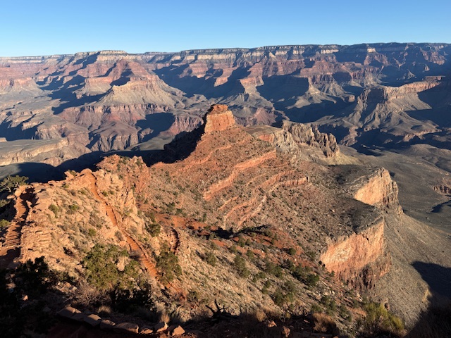
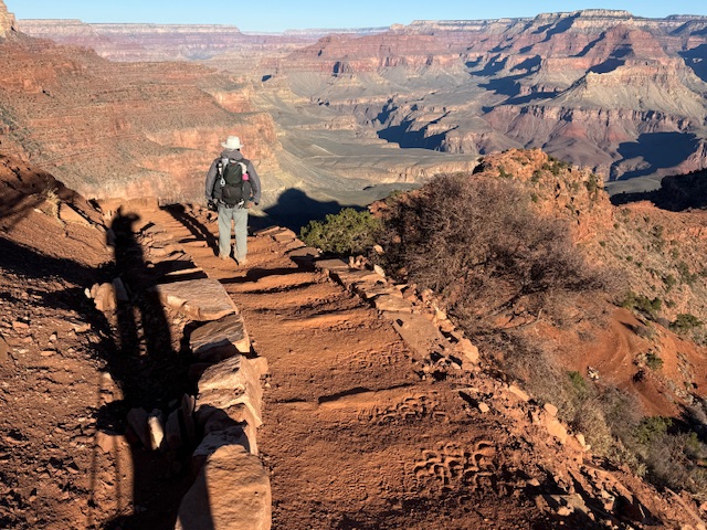
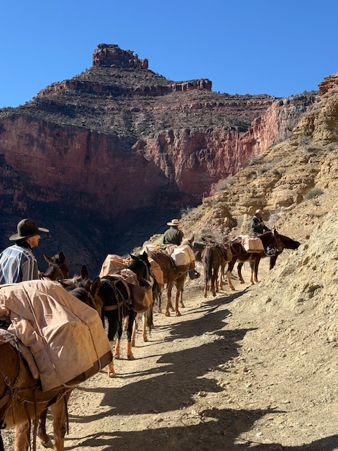
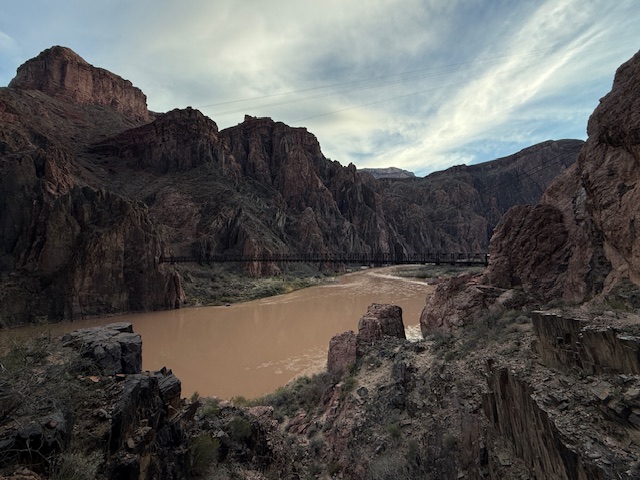
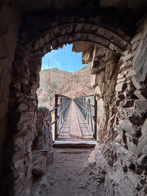
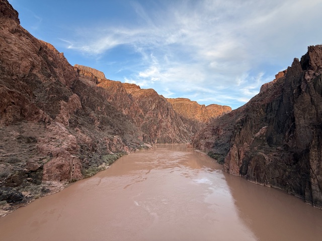
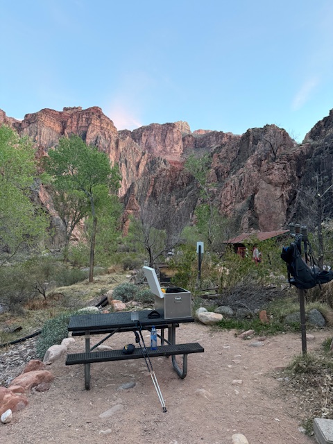
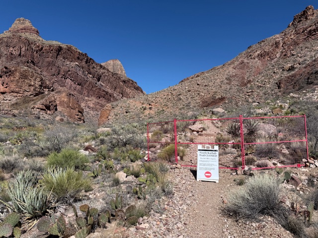
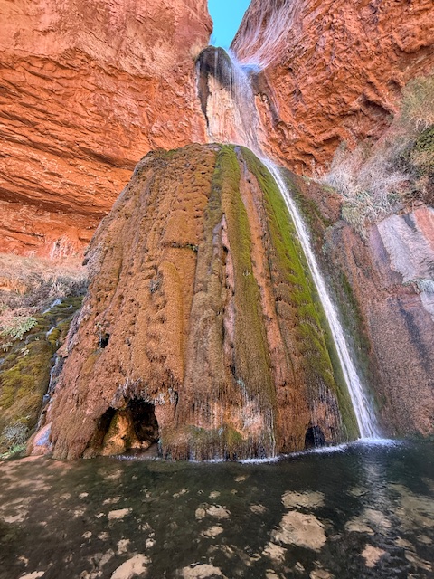
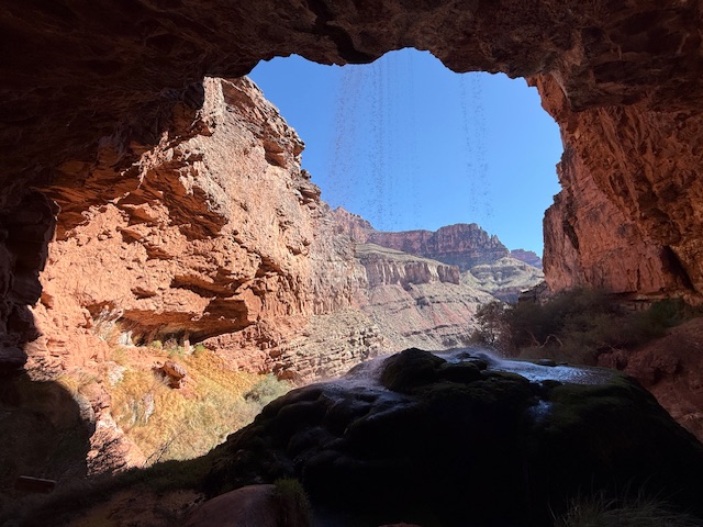
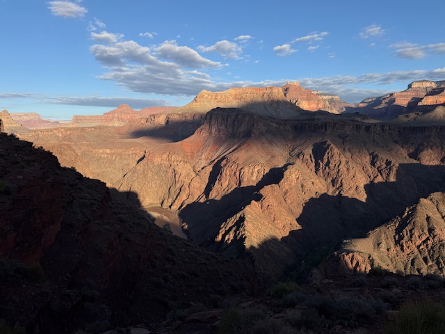
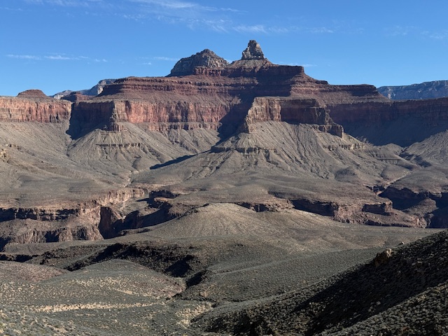
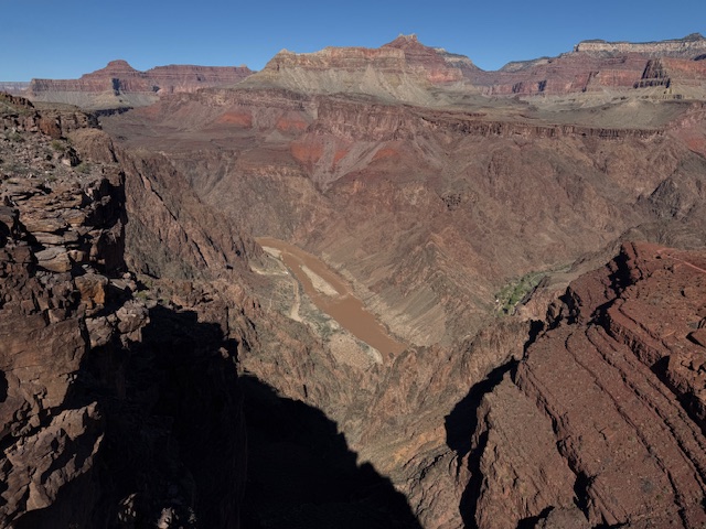
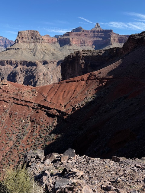
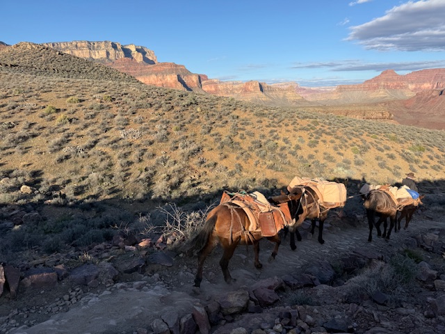
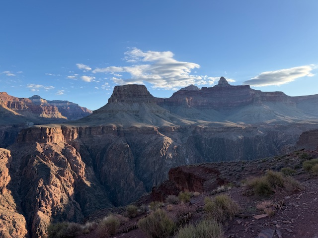
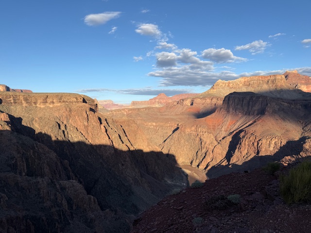
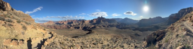
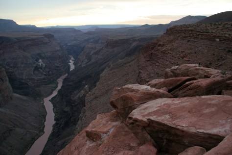
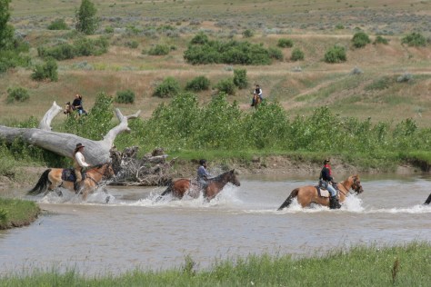
Since the Arizona National Scenic Trail cannot be done as a thru-hike this year, I took a non-traditional approach and started at Mile 700 in Grand Canyon National Park. Due to last summer’s Dragon Bravo Fire, more than 20 miles of the trail is closed on the North Rim. The six-mile stretch of North Kaibab Trail to Ribbon Falls opened up this week, so I made a reservation to spend the night in Bright Angel Campground. The weather was perfect, the scenery sublime, there were lots of ravens flying around, and (as I read) this time of year there were no bugs so I “cowboy camped” without a tent. What a privilege to get a campsite in such an incredible place listening to the creek. I carried my full backpack the seven miles down to the campground, then stashed most of my gear, refilled my water bottle, and headed six miles to the thigh-deep stream crossing for stunning Ribbon Falls, with an elevation gain of about 1,900 feet from the Colorado River. All told, I descended about 7,000 feet across 23 miles on Wednesday, but my left knee held up really well, either due to all the training or trekking poles. Thursday morning I made the hike out in three hours, impressing myself. I feel ready for the physical challenge of the 800-mile Arizona Trail! I am very grateful to be able to choose to do this hard and rewarding type of activity in my beautiful home state.
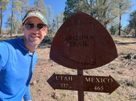
This week I am starting out northbound on the Arizona National Scenic Trail. According to the official website, it is 800 miles (with 105,000 feet of cumulative elevation gain) from the international border with Mexico in Coronado National Memorial to the Stateline Campground on the Utah border in Vermilion Cliffs National Monument. Due to last summer’s Dragon Bravo Fire in Grand Canyon National Park, more than 20 miles of the trail is closed on the North Rim making a thru-hike impossible this year. Since I am already in northern Arizona, I am going to begin by backpacking to the bottom of the Grand Canyon to spend one night before turning around and driving south to the official start. That will be on Wednesday! Once I return to Grand Canyon National Park (Mile 700), I will get a ride north to finish up the trail.
I recently moved back to Arizona for the 5th time in my life and I thought backpacking across the state would be a great way to reconnect. If you haven’t already read it, check out my 7-day Arizona Road Trip Itinerary with plenty of options to make it a month-long visit.
Once I finish the Arizona Trail, then I will get back to writing my latest guidebook American History 101: Reliving a Country’s Past at 101 National Park Service Sites, which I hope to publish by July 4, 2026, for the 250th anniversary of the vote to approve the Declaration of Independence.
Here are links to my blog posts on the public lands I will be traversing on the Arizona Trail:
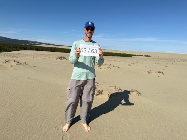
For years I have been helping my Mom visit National Parks and she enjoys seeing new places and adding a sticker to her National Parks water bottle. In June 2025, together we finally made it to Kobuk Valley National Park in Alaska (my last of the 63 National Parks and 401 of 433 NPS sites). Recently we went to Big Bend National Park, number 55 of 63 for her. It was my third visit there, but I hiked several new trails and it made me think about how there are so many different places to explore in some of the National Parks. I have returned to most of the parks in researching my travel guidebooks, so I thought I would make a list of my favorite ones that I keep going back to. I was surprised how the list varied from my rankings of the Top 10 National Parks and Top 10 National Parks for Hiking (click here to see all our Top 10 Lists).
If you or someone you love are interested in visiting the 63 National Parks, our travel guidebook A Park to Yourself makes a great gift!
So many trails to hike through ecosystems ranging from the coast to the alpine regions; after multiple visits, I am still hoping to make it to Staircase someday.
You have to come in multiple seasons because spring is best for waterfall flow, Glacier Point and Tuolumne Meadows are closed in the winter, Half Dome has chains in the summer (reservations required), and Horsetail Fall only glows at sunset in late February (reservations required).
Countless trails to waterfalls (if you can find a parking spot), amazing fall foliage, the seasonal road closure to Clingman’s Dome, and backpacking the Appalachian National Scenic Trail all mean this a year round destination.
It takes good planning to visit both the North and South Rims in one trip, plus it is worth the long drive to see Toroweap (free online permit required). If you are able, hike to the bottom of the canyon or take a long float trip on the Colorado River.
The road across the park closes in the winter, when snowshoeing is still possible from many trailheads on both the west and east sides. High elevations open up for exploration after spring snowmelt, as does the Continental Divide National Scenic Trail.
A great National Park to hike and drive in the winter, the elevations of Chisos Basin are inviting when the desert heats up the rest of the year. I still want to canoe part of the Rio Grande Wild and Scenic River.
I prefer snowshoeing through the sequoia groves in the winter, when you can also reserve a bed in the Pear Lake Ski Hut. Summer melts the High Sierra for exploration, including Mt. Whitney (permits required).
…and finally the #1 National Park for multiple return visits:
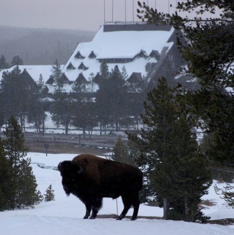
If you have never been to the world’s first National Park in the winter, then book your snow coach (or snowmobile) and lodging as soon as possible. It is very different than a summer visit and wildlife is still abundant (except bears). I have been to Yellowstone more than a dozen times and plan to return.
There are two different entrances east and west that are a long drive apart, both have hiking access to different caves (check before going to avoid seasonal closures).
The unpredictability of lava flows mean that you might have to come back to see active eruptions, or maybe you want to make the strenuous backpacking trip to the top of Mauna Loa. Who wouldn’t want to return to the Big Island?
This is a personal favorite because of the Wild Caving Tour and free permits to backpack on the prairie with the free-ranging bison herd. The Black Hills keep calling me back.
After we published our guidebook 50 States of Great: Road Trip Guide to America in 2023, we decided to start a new type of blog post where we create a travel itinerary for all 50 states, in addition to our usual public land entries. After starting with Kansas, Georgia, Idaho, Rhode Island, Minnesota, Hawai’i, Arizona, Louisiana, South Dakota, and Indiana, we decided to head back west to Montana. There are so many great trails in the state’s National Forests that we had a difficult time narrowing it down. We made an ambitious seven-day plan starting in southeast Montana on Interstate 90, with enough options to easily extend the trip into three weeks or more.
The best time to visit the National Monument is around June 25, the anniversary of Custer’s Last Stand when a reenactment of the battle is held on private land bordering the National Park Service site.
Makoshika State Park
It is illegal to remove dinosaur fossils from these badlands, but there are many on display at the visitor center, in addition to nearby museums (plus reservations can be made to dig on private land). The few campsites are in high demand to spend the night in these colorful canyons where caprocks rise high above juniper trees.
Optional stop at Pompeys Pillar National Monument
A sandstone monolith on the Yellowstone River has been a place for humans to record their passing for 11,000 years. The most famous inscription was left by Captain William Clark on July 25, 1806, the sole on-site evidence of the Corps of Discovery’s three-year journey.
This underappreciated gem in the National Park Service system features gorgeous scenery and abundant wildlife, including bighorn sheep and wild horses. The highlight is across the state line in Wyoming where Devil Canyon Overlook sits atop cliffs that drop over 1,000 feet straight down to the level of the narrow reservoir.
Gallatin Petrified Forest is only accessible by trail, either from a short two-mile one-way jaunt or by backpacking the 27-mile Gallatin Divide-Devils Backbone Trail. Earthquake Lake Geologic Area stretches along Highway 287 to commemorate the events that occurred around midnight on August 17, 1959, when a deadly magnitude 7.5 earthquake hit West Yellowstone.
Some of the National Forest’s miles of hiking trails access the Crazy Mountains and Hellroaring Plateau. The two-mile Glacier Lake Trail steadily climbs 1,100 feet then drops into a bowl containing a stunning reservoir that straddles the Wyoming-Montana border.
Optional drive on Beartooth All-American Road
Custer National Forest is famous for its stretch of Highway 212 that climbs from the prairie around the town of Red Lodge up to 10,947 feet at Beartooth Pass across the Wyoming border in Shoshone National Forest. The road follows the southern border of the giant 943,626-acre Absaroka-Beartooth Wilderness, which contains the highest point in Montana.
Located mostly in Wyoming and partly in Montana and Idaho, you could easily spend an entire summer in the world’s first National Park and not see all the thermal features, lakes, waterfalls, wildlife, and hiking trails.
Day 3
Lewis & Clark Caverns State Park
Once a U.S. National Monument, the state now runs a campground here and offers guided tours through a limestone show cave where bats live in the summer.
The free Potosi Campground is situated near the trailhead for Upper Potosi Hot Springs where a 0.8-mile trail leads past the uphill side of a clear 100°F pool with room for about six adults.
Optional stop at Chico Hot Springs
If you leave Yellowstone National Park north through Gardiner on Highway 89, consider stopping at this developed hot springs (fee) that offers live music poolside on some nights (especially if the park’s Boiling River was closed). In business since 1897, even Teddy Roosevelt stopped to rest here.
Day 4
Bannack State Park
East of Lemhi Pass on the Idaho border (which is also the Continental Divide National Scenic Trail through there), Bannack State Park preserves more than 50 buildings from a gold rush town that was the territorial capital in 1864.
The site of a surprise attack by the U.S. Army on the morning of August 9, 1877, where Nez Perce warriors forced the troops to retreat, capturing a Howitzer cannon and allowing women and children to escape toward the newly created Yellowstone National Park. Part of the widespread Nez Perce National Historical Park, a small visitor center here overlooks the battlefield and a paved road accesses trails through it.
Blodgett Creek Trail leads 12.6 miles one-way to Blodgett Lake, but you do not have to go that far to appreciate its incredible beauty.
Optional stop at Elkhorn Hot Springs
In the Pioneer Mountains, about ten miles north of Highway 278 is the privately owned Elkhorn Hot Springs (fee), a great place to relax after hiking. There is free dispersed camping to the north in Beaverhead National Forest.
Day 5
Travelers’ Rest State Park
Follow in the footsteps of the Lewis and Clark expedition by driving the Lolo Trail (Highway 12), soaking at Lolo Hot Springs, or walking around Travelers’ Rest State Park (still a great place to camp).
Missoula
Do as the University of Montana students do and float tubes down the Clark Fork River through town. In the summer, look for webcam-famous Iris the Osprey in the parking lot near the football stadium. The Historical Museum at Fort Missoula preserves buildings dating back to 1877, including an Alien Detention Center used during World War II.
Outside Missoula, there are many trails in Rattlesnake National Recreation Area and Blue Mountain Recreation Area, plus the Aerial Fire Depot and Smokejumper Center, Ninemile Historic Remount Depot, and Savenac Historic Tree Nursery Area.
This working ranch commemorates the nineteenth-century lifestyle of cattle barons and cowboys. Free guided tours are offered inside the large ranch house, and a self-guided walking tour enters 15 buildings with displays on the history of barbwire, branding irons, and much more.
Day 6
National Bison Range
Established in 1908 under President Theodore Roosevelt and now run by the Confederated Salish and Kootenai Tribes. Start at the visitor center, then take the 19-mile Red Sleep Mountain Drive to see mule deer, white-tailed deer, elk, pronghorns, bighorn sheep, and the namesake bison.
Jewel Basin Hiking Area is famous among backpackers, and further south so is Holland Lake, which has several campgrounds. The steep Holland-Gordon Trail passes Holland Falls as it climbs 2,100 feet in 5.8 miles to Upper Holland Lake and continues into “the Bob” (Bob Marshall Wilderness). Flathead National Forest contains more than 2,800 miles of hiking trails, including 38 miles of the Pacific Northwest National Scenic Trail and a stretch of the Continental Divide National Scenic Trail.
Optional stop at Mission Mountains Wilderness
Located within Flathead National Forest, a popular trail accesses multiple mountain lakes; it is only 1.5 miles one-way to Glacier Lake, but we recommend continuing to Turquoise Lake. It borders the Mission Mountains Tribal Wilderness (permits required).
Waterton-Glacier International Peace Park’s renowned Going-to-the-Sun Road was built to cross the park from east to west in the 1920s (reservations are required to drive it between 7 a.m. and 3 p.m. in the summer). At its highest point at 6,646-foot Logan Pass, the road crosses the Continental Divide National Scenic Trail.
In the state’s northwest corner, incredible views await at Blue Mountain Trail, Skyline National Recreation Trail, Scenery Mountain Lookout Trail, Ross Creek Scenic Area of old-growth western redcedar trees, and Kootenai Falls (located in a county park on the side of Highway 2).
Meriwether Lewis named the Gates of the Mountains on July 19, 1805, and today a two-hour jet boat tour on the Missouri River provides history on the Corps of Discovery, American Indian pictographs, the Mann Gulch Fire, and the collapse of Hauser Dam. A trail through Refrigerator Canyon is less than ten feet wide at its narrowest point, where towering 200-foot limestone cliffs keep it cool and breezy throughout the summer.
Great Falls
North of Helena on Interstate 15 is the Lewis and Clark Interpretive Center (fee), which is managed by the U.S. Forest Service on the banks of the Missouri River.
This 375,000-acre National Monument preserves a stretch of the Missouri River that still looks much the way it did when Lewis and Clark explored it. Start your journey by paying for permits at the Bureau of Land Management interpretive center in historic Fort Benton, where you can launch your canoe or kayak to access 149 miles of the river. There are developed boat camps with vault toilets along the route, or you can pick your own spot near one of the Corps of Discovery campsite markers.
It includes portions of the Boulder Mountains, Flint Creek Range, and Elkhorn Mountains, as well as part of the Anaconda-Pintler Wilderness. Our favorite hike is Haystack Mountain National Recreation Trail off Interstate 15, where a climb of 2,000 feet ends at a mountaintop boulder field with panoramic views and the remnants of a fire lookout tower.
Backpacking is a major draw with trails in the Snowy Mountain Range and parts of the Scapegoat and Bob Marshall Wilderness areas, which provide crucial habitat for grizzly bears. It encompasses one of the most famous formations along the Continental Divide National Scenic Trail, the 15-mile long Chinese Wall (a 1,000-foot-tall cliff composed of five-million-year-old limestone).
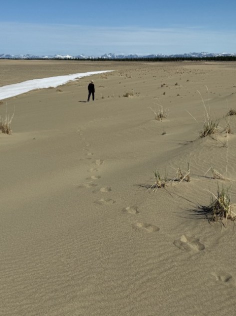
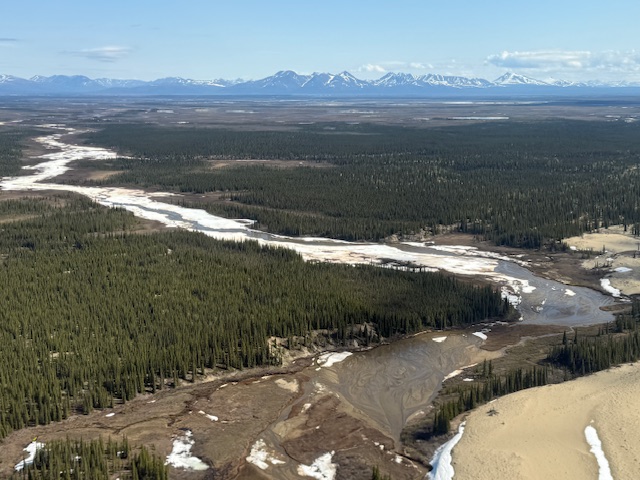
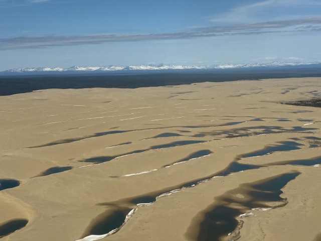
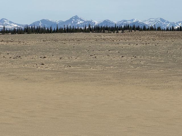
In northwest Alaska, an area roughly the size of Delaware is set aside to protect an 85-mile stretch of the Kobuk River. Kobuk Valley National Park also includes the Waring Mountains to the south and the Baird Mountains that border Noatak National Preserve. Hunters have been coming for at least 12,500 years to Onion Portage where caribou gather to cross the river. In the 1960s, archeologist J. Louis Giddings built a cabin and cache so he could excavate a two-acre plot. He and his assistants dug through 30 artifact-bearing layers that provided evidence of nine cultural periods from the Akmak Complex to the Arctic Woodland Eskimo.
Great Kobuk Sand Dunes, Onion Portage Archeological District
Must-Do Activity
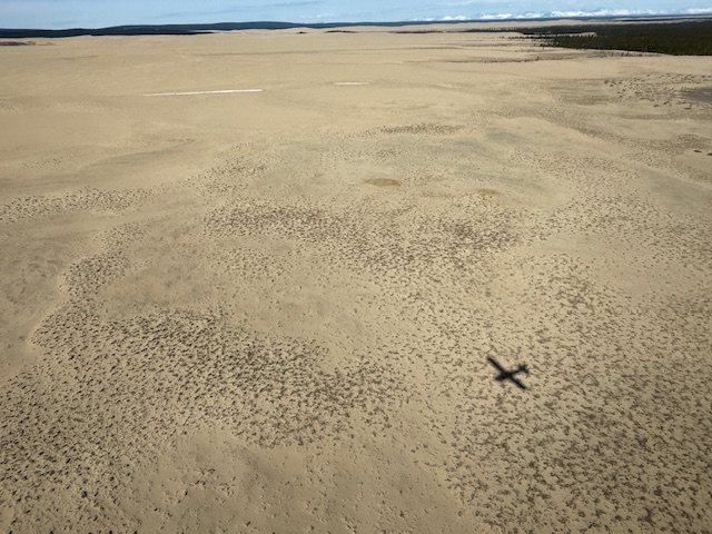
The Northwest Arctic Heritage Center in Kotzebue is located 75 river miles from the western edge of the park. Riverside ranger stations operate in the summer at Kallarichuk in the west and Onion Portage in the east. A flightseeing tour of the park typically lands on the Great Kobuk Sand Dunes, which are the remnant of a dune field that once covered as much as 200,000 acres after the Pleistocene glaciation. Float trips take at least a week on the wide Kobuk River or the rougher Salmon River, which is designated a Wild and Scenic River. The Kobuk River starts within a narrow canyon with Class V rapids inside Gates of the Arctic National Park and Preserve, but soon flattens out and becomes a braided channel, like many rivers in Alaska.
Best Trail
There are no established trails in the park, but it is easy to wander through the sand dunes and soft enough to go barefoot.
Photographic Opportunity
The Great Kobuk Sand Dunes are a geological anomaly sitting north of the Arctic Circle, once studied by NASA as an analog for polar dunes on Mars.
There are no roads into Kobuk Valley National Park, so most visitors arrive by small airplane, which can cost around $5,000 to charter for the day. If you are leaving from Fairbanks, we recommend flying with Sven from Aviation Expeditions who will do a combination trip that also lands in Gates of the Arctic National Park and Preserve.
Camping
Backcountry camping is allowed throughout the park, but is not permitted on the 81,000 acres of Native Corporation lands that are typically situated along the rivers.
Related Sites
Gates of the Arctic National Park and Preserve (Alaska)