Tag Archives: National Monument

Birmingham Civil Rights National Monument

Birmingham Civil Rights National Monument

Alabama

Managed by National Park Service

Established 2017

18 acres

Website: nps.gov/bicr

Overview

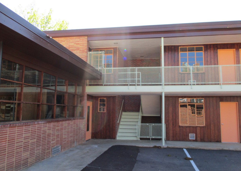
Created by President Barack Obama on January 12, 2017 (the same day as Freedom Riders and Reconstruction Era National Monuments), this site encompasses four city blocks of downtown within the larger 36-acre Birmingham Civil Rights District.  In 1963, this area was where the 16th Street Baptist Church was bombed and the Children’s Crusade (a non-violent protest march) was attacked by policemen with water hoses and dogs.  The only portion of the site run by the National Park Service (NPS) is the A. G. Gaston Motel, which was bombed by the KKK after Rev. Martin Luther King, Jr. and other civil rights leaders stayed there from April through May 1963 to plan their non-violent campaign against segregation laws.  The City of Birmingham and the NPS have restored the motel to its historic appearance and a park ranger is stationed there three days a week.

Learn more about the other 137 National Monuments in our book Monumental America: Your Guide to All 138 National Monuments. It is now available for sale on Amazon.com.

Highlights

Birmingham Civil Rights Institute, A.G. Gaston Motel, 16th Street Baptist Church, Kelly Ingram Park, St. Paul United Methodist Church, Bethel Baptist Church

Must-Do Activity

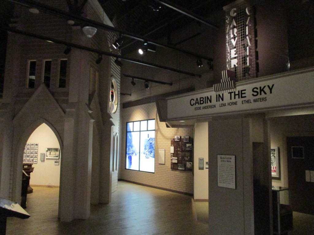
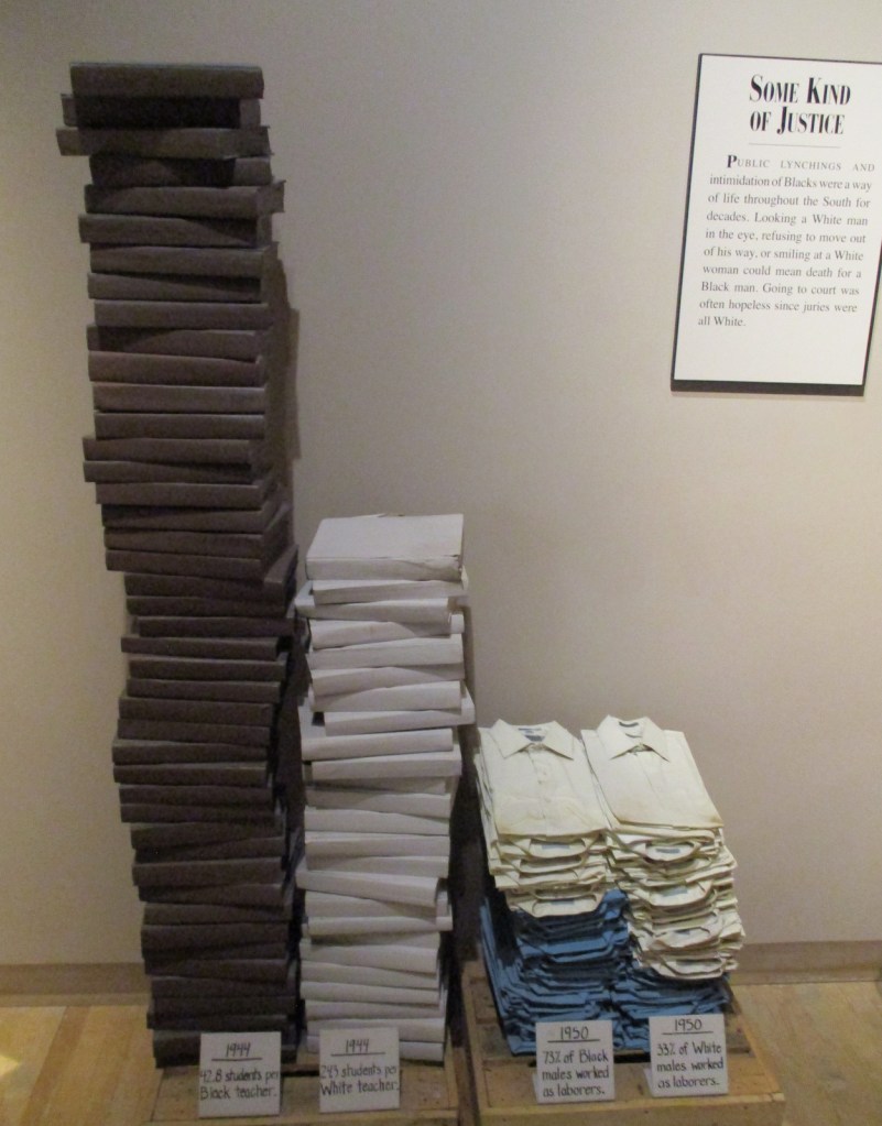
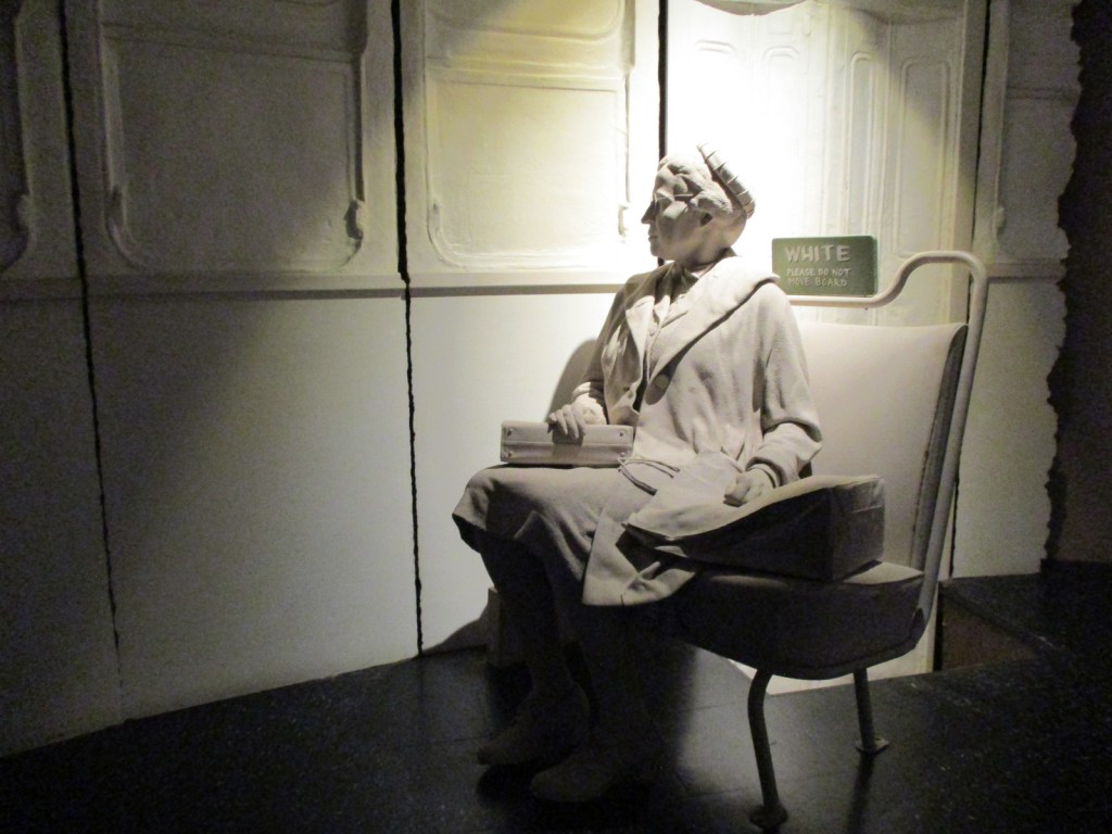
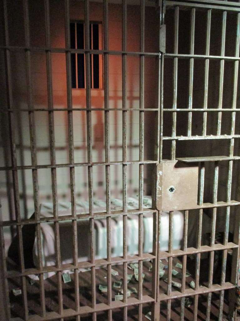
The Birmingham Civil Rights Institute is a history museum that opened in 1992 across from the 16th Street Baptist Church (see Photographic Opportunity).  With a timed entry ticket, your self-guided tour starts with a short video, then an immersive walk through the struggle for civil rights in Birmingham and around the U.S.  It includes powerful displays on the Freedom Riders bus burning and Rev. Martin Luther King, Jr.’s “Letter from Birmingham Jail,” as well as the decades-long effort to bring to justice the bombers of the 16th Street Baptist Church.  If you come on one of the three days per week that a park ranger is posted at the A.G. Gaston Motel, be sure to stop there afterwards to see the ongoing reconstruction work.  Six miles north of the city in the Collegeville neighborhood, Bethel Baptist Church was bombed three times in 1956, 1958 and 1962, partly why the city earned the nickname “Bombingham.”  The church is associated with the influential Rev. Fred Shuttlesworth, who has a statue outside the Birmingham Civil Rights Institute.

Best Trail

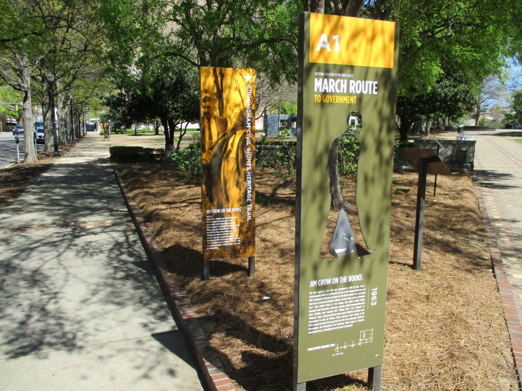
Across the street from the Birmingham Civil Rights Institute, Kelly Ingram Park features sculptures, interpretive signs, and an audio tour describing the violent attacks by police officers and dogs on civil rights protesters (many of them children) on May 7, 1963.

Photographic Opportunity

Across the street from the Birmingham Civil Rights Institute, 16th Street Baptist Church was bombed on September 15, 1963, killing four young girls, an act of domestic terrorism that propelled the passage of the Civil Rights Act of 1964.  Tours inside the church are by appointment only.

Peak Season

Spring and fall

Hours

The A.G. Gaston Motel is open Thursday through Saturday 10 a.m. to 4 p.m. and the Birmingham Civil Rights Institute is open Tuesday through Saturday 10 a.m. to 5 p.m.

https://www.nps.gov/bicr/planyourvisit/hours.htm

Fees

No cost for the A.G. Gaston Motel or Kelly Ingram Park, but there is an admission fee at the Birmingham Civil Rights Institute (online reservations recommended).

Road Conditions

All roads are paved with a free parking lot next to the Birmingham Civil Rights Institute.

Camping

In northeast Alabama, De Soto State Park offers camping, in addition to excellent hiking trails to several waterfalls.  There are also three backcountry campsites in Little River Canyon National Preserve available from February through September with a permit.  Cheaha State Park and Joe Wheeler State Park both have campgrounds and lodges.  Talladega, Tuskegee, and William B. Bankhead National Forests also offer car camping and backpacking opportunities.

Related Sites

Freedom Riders National Monument (Alabama)

Horseshoe Bend National Military Park (Alabama)

Tuskegee Airmen National Historic Site (Alabama)

Explore More – When did the City of Birmingham establish the 36-acre Birmingham Civil Rights District?

Learn more about the other 137 National Monuments in our book Monumental America: Your Guide to All 138 National Monuments

Navajo National Monument

Navajo National Monument

Arizona

Managed by National Park Service

Established 1909

360 acres

Website: nps.gov/nava

Overview

Navajo National Monument was created to protect the Keet Seel ruin on the Navajo Nation, although the Ancestral Puebloan people who lived here in the 1200s are more closely related to the Hopi and Zuni.  Three years later, the ruins at Betatakin and Inscription House (closed to the public) were added to the National Monument. We had such a great visit that we had to add it to his list of Top 10 National Monuments

Learn more about the other 137 National Monuments in our book Monumental America: Your Guide to All 138 National Monuments. It is now available for sale on Amazon.com.

Highlights

Tsegi Point Overlook, museum, film, Sandal Trail, Keet Seel overnight trip

Must-Do Activity

During the pandemic, the National Park Service (NPS) closed all access to the ruins until 2023, but visitors can now reserve spots on the 20-person ranger-led backpacking trips to Keet Seel that are offered twice per month in the summer.  This strenuous trip covers 17 miles total with numerous stream crossings and all water must be carried in.  The hardest part is at the end, when a 1,000 foot climb awaits, but it is worth it to be one of the few who get to see Keet Seel, the 150-room ruin that is second in size only to Cliff Palace at Mesa Verde National Park.  You also get to eat lunch at a surprisingly large waterfall in Keet Seel Canyon.  For those looking for a shorter five-mile trip with only 580 feet elevation change, weekend day hikes to Betatakin are led by park rangers (sign up the day before on a first-come, first-served basis).

Best Trail

From the NPS visitor center (which is actually on Navajo land outside the National Monument boundary), the paved Sandal Trail follows the canyon rim to an overlook of the Betatakin cliff dwelling.  There are signs explaining the local plant species and their uses by indigenous people on the 1.3-mile out-and-back trail.  The 0.8-mile roundtrip Aspen Trail and 0.8-mile Canyon View Trail also leave from the visitor center.

Photographic Opportunity

Outside the visitor center, a replica sweathouse and male hogan are on display, plus examples of three-toed dinosaur footprints left in the sandstone.  Inside the visitor center, pottery and an example of a family dwelling are on display, plus a short introductory film is offered.

Peak Season

Summer

Hours

https://www.nps.gov/nava/planyourvisit/hours.htm

Fees

None

Road Conditions

Highway 564 is paved to the visitor center and Sunset View Campground, then a good dirt road leads to the Canyon View Campground and gated trailhead for ranger-led hikes to Betatakin and Keet Seel.

Camping

The free Sunset View Campground has running water and is one of the nicest campgrounds in the entire NPS system (now added to the Top 10 National Park Campgrounds with Running Water).  There are vault toilets at Canyon View Campground, which is also free.  Campers are limited to a total of seven nights per year at the campgrounds.

Related Sites

Hubbell Trading Post National Historic Site (Arizona)

Canyon de Chelly National Monument (Arizona)

Walnut Canyon National Monument (Arizona)

Explore More – When was the large white fir tree added above the main entrance to Keet Seel cliff dwelling?

Learn more about the other 137 National Monuments in our book Monumental America: Your Guide to All 138 National Monuments

Baaj Nwaavjo I’tah Kukveni–Ancestral Footprints of the Grand Canyon National Monument

Baaj Nwaavjo I’tah Kukveni–Ancestral Footprints of the Grand Canyon National Monument

Arizona

Managed by U.S. Forest Service, Bureau of Land Management

Established 2023

917,618 acres

Website: https://www.blm.gov/national-conservation-lands/arizona/ancestral-footprints

Overview

This new National Monument is situated on both the North and South Rim of the Grand Canyon, but outside the boundaries of Grand Canyon National Park.  It includes the entirety of the Tusayan District of Kaibab National Forest on the South Rim, as well as two sections east and west of the 9,000-foot Kaibab Plateau on the Arizona Strip.  Its name is derived from the Havasupai words Baaj Nwaavjo, which translate as “where indigenous peoples roam,” plus the Hopi term I’tah Kukveni, which means “our ancestral footprints.”  According to the Bureau of Land Management (BLM) website it is pronounced “Baahj-Nuh-Waahv-Joh, Ee-Tah-Kook-Venny.”  The National Monument was created primarily to prevent future uranium mining claims in this area and further protect evidence of thousands of years of human habitation (see Best Trail).

Learn more about the other 137 National Monuments in our book Monumental America: Your Guide to All 138 National Monuments. It is now available for sale on Amazon.com.

Highlights

Red Butte, Hull Cabin, Apex Logging Camp, Grand Canyon Airport Historic District, Marble Canyon, Snake Gulch, Arizona National Scenic Trail

Must-Do Activity

Red Butte is located just east of paved Highway 64/180 on the way to Grand Canyon National Park’s South Rim.  A short 3.3-mile out-and-back trail with 912 feet of elevation gain is found at this geological formation sacred to the Havasupai, Hualapai, Navajo, Hopi, and Zuni people.  Also in this area, Hull Cabin dates back to 1889 and Apex Logging Camp was situated along the Grand Canyon Railroad between 1928 and 1936 (although not much remains other than the foundation of a one-room schoolhouse).  The Arizona National Scenic Trail runs through this part of Kaibab National Forest before entering the Grand Canyon and crossing the Kaibab Plateau.

Best Trail

Snake Gulch-Kanab Creek Trail #59 starts at the end of unpaved Forest Road 642 (about five miles from the end of pavement on Forest Highway 22).  It soon passes an old homestead and turns left to enter the canyon, part of the extensive Kanab Creek Wilderness (and within the National Monument boundary).  The first pictographs can be seen about 2.5 miles in and from then on consistently on the north side of the canyon.  The images are primarily done in red paint from the Basketmaker People who resided in this region from 300 BCE to AD 800.  We hiked in seven miles then turned around as it started to get really hot in late June, but the trail through the canyon continues 21 miles to where it connects with Ranger Trail #41.  Our favorite pictographs were located about four miles in, which would make a good turnaround point for a day hike.

Instagram-worthy Photo

Stop at the historic Navajo Bridge that crosses the Colorado River at Marble Canyon where four public lands meet: Grand Canyon National Park, Glen Canyon National Recreation Area, Vermilion Cliffs National Monument, and Baaj Nwaavjo I’tah Kukveni-Ancestral Footprints of the Grand Canyon National Monument.

Peak Season

Spring and fall, as summer can be very hot

Hours

Navajo Bridge Visitor Center (National Park Service)

https://www.nps.gov/glca/planyourvisit/visitorcenters.htm

Fees

None

Road Conditions

There are many unpaved and four-wheel-drive-only roads spread across this area, but Highway 64/180 to the South Rim is paved.  High clearance is recommended to access Snake Gulch-Kanab Creek Trailhead.  Highway 67 and most Forest Roads on the Kaibab Plateau are closed in winter due to heavy snowfall.

Camping

There are good, dispersed camping options throughout Kaibab National Forest, including along the dirt roads just outside the east entrance of Grand Canyon National Park’s South Rim before entering the Navajo Nation.

Related Sites

Glen Canyon National Recreation Area (Arizona-Utah)

Vermilion Cliffs National Monument (Arizona)

Grand Canyon-Parashant National Monument (Arizona)

Pipe Spring National Monument (Arizona)

Explore More – When were beefalo (bison and cattle mix) introduced to the House Rock Valley area west of Marble Canyon (and now found roaming inside Grand Canyon National Park and Kaibab National Forest)?

Learn more about the other 137 National Monuments in our book Monumental America: Your Guide to All 138 National Monuments

Kaibab National Forest

Kaibab National Forest

Arizona

Managed by U.S. Forest Service, Southwestern Region

1,601,066 acres (1,560,165 federal/ 40,901 other)

Website: https://www.fs.usda.gov/kaibab

Overview

Kaibab National Forest is located both north and south of Grand Canyon National Park, although the paved road from Jacob Lake to the North Rim is closed throughout the winter months due to heavy snowfall on the 9,000-foot Kaibab Plateau.  There are numerous dirt roads to explore on each side of the canyon that in 2023 were encompassed into Baaj Nwaavjo I’tah Kukveni – Ancestral Footprints of the Grand Canyon National Monument (see our blog post).  The Grand Canyon Forest Reserve was first set aside in 1893, then became Kaibab National Forest in 1908 before Grand Canyon National Park was removed from its acreage a decade later.  In 1934, the southern Tusayan National Forest was joined to form the present boundaries.

Know someone who loves the National Forests? Gift them our travel guidebook Out in the Woods so they can learn more about all 155 National Forests.

Highlights

Kaibab Plateau Scenic Byway, Hull Cabin, Snake Gulch, Kendrick Peak, Sycamore Canyon, Beale Wagon Road, Overland Road, Bill Williams Mountain, Kanab Creek Wilderness, Thunder River Trail

Must-Do Activity

The highest point in Kaibab National Forest is 10,418-foot Kendrick Peak located in the Kendrick Peak Wilderness northwest of Flagstaff, which experienced a large wildfire in 2000.  Scott started as a student at Northern Arizona University the next year, and has been able to watch this area recover over the decades since.  Seven miles of dirt roads leave Highway 180 to access the Kendrick Mountain Trailhead at 7,980 feet in elevation.  A steep, switchbacking 4.6-mile one-way trail partly follows a closed road to the top past Old Lookout Cabin (built in 1912).  Bull Basin and Pumpkin Trails also lead to Kendrick Peak, but require more dirt road driving.  From the summit, views are good north towards the Grand Canyon and east to the taller San Francisco Peaks within Coconino National Forest

Best Trail

Bill Williams Mountain dominates the skyline in the town of Williams, the southern terminus of the 65-mile-long Grand Canyon Railway.  Several routes climb to the top of the peak, but Bixler Saddle Trail starts higher than the others at 7,700 feet.  It is accessed by a rocky road that leads to a small parking area at the saddle.  From there the trail gains 1,000 feet in elevation in 2.5 miles before connecting with Bill Williams Mountain Trail to finish climbing a half-mile to the lookout tower at 9,256 feet.  No matter how you summit, at the top there are breathtaking views in all directions.

Watchable Wildlife

Elk and mule deer are commonly seen on both sides of the Grand Canyon.  Apparently, bison were introduced in the early 1900s and now roam freely in the National Forest, in addition to mountain lions, bobcats, and black bears.  The canyon formed a natural barrier for the evolution of distantly-related Kaibab squirrels on the North Rim, a subspecies of the Abert’s squirrels found on the South Rim.  Common birds include wild turkeys, robins, nuthatches, northern flickers, rufous hummingbirds, Steller jays, American crows, common ravens, and a variety of hawks.  Fishing is a popular activity, with some excellent trout streams found in the National Forest.

Instagram-worthy Photo

There are five trailheads that access the 12-mile Sycamore Rim Trail loop, located south of Interstate 40 after driving ten miles of good dirt road.  The trail passes through a ponderosa pine forest with overlooks of the Sycamore Canyon Wilderness, also managed by Coconino and Prescott National Forests.

Peak Season

Summer

Fees

None

Road Conditions

The paved road from Jacob Lake, Arizona to the North Rim of Grand Canyon National Park is closed throughout the winter months due to heavy snowfall.  There are countless miles of dirt roads on each side of the canyon that access trailheads and allow for dispersed camping.

Camping

There are numerous campgrounds spread throughout the National Forest, as well as rentals of the historic 1917 Spring Valley Cabin and 1889 Hull Cabin (within the newly created Baaj Nwaavjo I’tah Kukveni – Ancestral Footprints of the Grand Canyon National Monument).

Wilderness Areas

Kanab Creek Wilderness

Kendrick Mountain Wilderness (also in Coconino National Forest)

Saddle Mountain Wilderness

Sycamore Canyon Wilderness (also in Coconino and Prescott National Forests)

Related Sites

Pipe Spring National Monument (Arizona)

Tuzigoot National Monument (Arizona)

Sunset Crater Volcano National Monument (Arizona)

Nearest National Park

Grand Canyon

Conifer Tree Species

ponderosa pine, limber pine, southwestern white pine, two-needle pinyon pine, Utah juniper, one-seed juniper, Rocky Mountain juniper, Douglas-fir, white fir, Engelmann spruce

Flowering Tree Species

Gambel oak, quaking aspen, boxelder, Arizona sycamore, Arizona walnut, Fremont cottonwood

Explore More – Kaibab is the Paiute name for the Grand Canyon, which translates as what?

Learn more about this and the 154 other National Forests in our new guidebook Out in the Woods

Emmett Till and Mamie Till-Mobley National Monument         

Emmett Till and Mamie Till-Mobley National Monument         

Mississippi, Illinois

Managed by National Park Service

Established 2023

5.7 acres

Website: nps.gov/till

Overview

In 1955, 14-year-old Emmett “Bo” Till left Chicago to visit family in Mississippi, where he whistled at Carolyn Bryant, a white woman who ran the Bryant’s Grocery & Meat Market in the town of Money.  A few nights later on August 28, Carolyn’s husband (Roy Bryant) and his half-brother (John William “J.W.” Milam) abducted Emmett Till from his relatives’ house.  They took Emmett to Milam’s farm where he was tortured and killed according to their admission in Look magazine a year later.  After Till’s body was recovered at Graball Landing and sent back to Chicago for a funeral, a five-day trial took place in Sumner’s Tallahatchie County Courthouse where Bryant and Milam were acquitted of the crime.  It is probably not a coincidence that the National Monument was proclaimed by President Joe Biden following the release of the 2022 film Till.  Not open to the public but also part of the National Monument in Illinois, the Roberts Temple Church of God in Christ in the Chicago neighborhood of Bronzeville is where Mamie Till-Mobley insisted on an open-casket funeral service so the public could see the terrible results of the murder.  Historians believe the outcry over this lynching of a 14-year-old boy helped lead to the Civil Rights Act of 1957.

Highlights

Emmett Till Interpretive Center, Tallahatchie County Courthouse, Emmett Till Historic Intrepid Center (ETHIC), Black Bayou Bridge, Graball Landing, Greenwood statue, Bryant’s Grocery site

Must-Do Activity

Emmett Till Historic Intrepid Center (ETHIC) is located in a former cotton gin near the site of Emmett Till’s torture and murder on the farm of “J.W.” Milam in Glendora, Mississippi.  Established in 2005, there is an atmosphere to the museum that bears the full weight of history, heightened by the short introductory video showing Emmett Till’s family members’ recollections of the events of 1955.  Inside, there is a recreation of the Bryant’s Grocery & Meat Market storefront, as well as a coffin with the prop used in the film Till depicting Emmett’s shockingly disfigured head.  The museum also has artifacts highlighting the Mississippi Delta’s history with slavery, indigenous people, and blues music (specifically Sonny Boy Williamson II).  Although not part of the National Monument, we recommend a half-hour drive south to Money to see the ruins of Bryant’s Grocery & Meat Market with a restored gas station next door, part of the Mississippi Freedom Trail.

Best Trail

From ETHIC, drive or walk to the Black Bayou Bridge where Emmett “Bo” Till’s body was dumped into the Black Bayou tied to a heavy fan from the cotton gin.  We were grateful to get a personal tour from Tamita Davis who helps run ETHIC.  It is also a short drive down a dirt road to Graball Landing on the Tallahatchie River where there is a small interpretive sign explaining it as the site Till’s body was recovered.

Instagram-worthy Photo

The National Park Service operates out of the Emmett Till Interpretive Center, located in a strip mall opposite the Tallahatchie County Second District Courthouse in Sumner, Mississippi.  It has limited hours, but the courtroom where the September 1955 trial was held was unlocked when we visited on a Tuesday morning. 

Peak Season

Spring and fall

Hours

In Sumner, the Emmett Till Interpretive Center is open to the public Tuesday through Saturday 12-5, while the Tallahatchie County Courthouse is open to the public on Mondays when the center is closed.  In Glendora, Emmett Till Historic Intrepid Center (ETHIC) is open Monday through Saturday 10-5.

Fees

$12 per adult at ETHIC, $5 donation recommended at Emmett Till Interpretive Center

Road Conditions

Paved roads lead to the Tallahatchie County Courthouse in Sumner and Emmett Till Historic Intrepid Center (ETHIC) in Glendora, where a gravel road in good shape leads to Graball Landing.

Camping

To the south, Delta National Forest offers online reservations for campsites (September through March when the forest is not seasonally flooded).

Related Sites

Medgar and Myrlie Evers Home National Monument (Mississippi)

Birmingham Civil Rights National Monument (Alabama)

Freedom Riders National Monument (Alabama)

Pullman National Historical Park (Illinois)

Explore More – A statue of Emmett Till was added in 2022 to Greenwood, Mississippi’s Rail Spike Park, but what city in Colorado has his statue alongside one of Dr. Martin Luther King, Jr.?