Tag Archives: architecture

Emmett Till and Mamie Till-Mobley National Monument         

Emmett Till and Mamie Till-Mobley National Monument         

Mississippi, Illinois

Managed by National Park Service

Established 2023

5.7 acres

Website: nps.gov/till

Overview

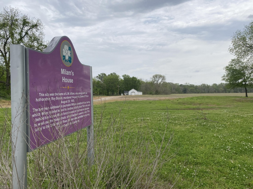
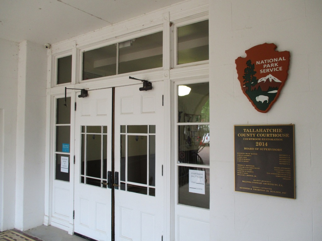
In 1955, 14-year-old Emmett “Bo” Till left Chicago to visit family in Mississippi, where he whistled at Carolyn Bryant, a white woman who ran the Bryant’s Grocery & Meat Market in the town of Money.  A few nights later on August 28, Carolyn’s husband (Roy Bryant) and his half-brother (John William “J.W.” Milam) abducted Emmett Till from his relatives’ house.  They took Emmett to Milam’s farm where he was tortured and killed according to their admission in Look magazine a year later.  After Till’s body was recovered at Graball Landing and sent back to Chicago for a funeral, a five-day trial took place in Sumner’s Tallahatchie County Courthouse where Bryant and Milam were acquitted of the crime.  It is probably not a coincidence that the National Monument was proclaimed by President Joe Biden following the release of the 2022 film Till.  Not open to the public but also part of the National Monument in Illinois, the Roberts Temple Church of God in Christ in the Chicago neighborhood of Bronzeville is where Mamie Till-Mobley insisted on an open-casket funeral service so the public could see the terrible results of the murder.  Historians believe the outcry over this lynching of a 14-year-old boy helped lead to the Civil Rights Act of 1957.

Highlights

Emmett Till Interpretive Center, Tallahatchie County Courthouse, Emmett Till Historic Intrepid Center (ETHIC), Black Bayou Bridge, Graball Landing, Greenwood statue, Bryant’s Grocery site

Must-Do Activity

Emmett Till Historic Intrepid Center (ETHIC) is located in a former cotton gin near the site of Emmett Till’s torture and murder on the farm of “J.W.” Milam in Glendora, Mississippi.  Established in 2005, there is an atmosphere to the museum that bears the full weight of history, heightened by the short introductory video showing Emmett Till’s family members’ recollections of the events of 1955.  Inside, there is a recreation of the Bryant’s Grocery & Meat Market storefront, as well as a coffin with the prop used in the film Till depicting Emmett’s shockingly disfigured head.  The museum also has artifacts highlighting the Mississippi Delta’s history with slavery, indigenous people, and blues music (specifically Sonny Boy Williamson II).  Although not part of the National Monument, we recommend a half-hour drive south to Money to see the ruins of Bryant’s Grocery & Meat Market with a restored gas station next door, part of the Mississippi Freedom Trail.

Best Trail

From ETHIC, drive or walk to the Black Bayou Bridge where Emmett “Bo” Till’s body was dumped into the Black Bayou tied to a heavy fan from the cotton gin.  We were grateful to get a personal tour from Tamita Davis who helps run ETHIC.  It is also a short drive down a dirt road to Graball Landing on the Tallahatchie River where there is a small interpretive sign explaining it as the site Till’s body was recovered.

Instagram-worthy Photo

The National Park Service operates out of the Emmett Till Interpretive Center, located in a strip mall opposite the Tallahatchie County Second District Courthouse in Sumner, Mississippi.  It has limited hours, but the courtroom where the September 1955 trial was held was unlocked when we visited on a Tuesday morning. 

Peak Season

Spring and fall

Hours

In Sumner, the Emmett Till Interpretive Center is open to the public Tuesday through Saturday 12-5, while the Tallahatchie County Courthouse is open to the public on Mondays when the center is closed.  In Glendora, Emmett Till Historic Intrepid Center (ETHIC) is open Monday through Saturday 10-5.

Fees

$12 per adult at ETHIC, $5 donation recommended at Emmett Till Interpretive Center

Road Conditions

Paved roads lead to the Tallahatchie County Courthouse in Sumner and Emmett Till Historic Intrepid Center (ETHIC) in Glendora, where a gravel road in good shape leads to Graball Landing.

Camping

To the south, Delta National Forest offers online reservations for campsites (September through March when the forest is not seasonally flooded).

Related Sites

Medgar and Myrlie Evers Home National Monument (Mississippi)

Birmingham Civil Rights National Monument (Alabama)

Freedom Riders National Monument (Alabama)

Pullman National Historical Park (Illinois)

Explore More – A statue of Emmett Till was added in 2022 to Greenwood, Mississippi’s Rail Spike Park, but what city in Colorado has his statue alongside one of Dr. Martin Luther King, Jr.?

Saugus Iron Works National Historic Site

Saugus Iron Works National Historic Site

Massachusetts

Managed by National Park Service

Established 1969

8.5 acres

Website: nps.gov/sair

Overview

Situated in the middle of the town of Saugus, this interesting little park preserves North America’s first integrated iron works dating back to 1646.  The site was chosen because of access to local bog iron, gabbro, ample trees for making charcoal, and the Saugus River for providing power and shipping.  Molten iron was poured into long sow bars that were forged into wrought iron, some of which went into a rolling and slitting mill that provided material for easily producing nails.  In addition to cast products like pots, other items made include hinges, hoes, shovels, kettle hooks, and tongs.  In the 1660s, bankruptcy led skilled iron workers (mostly indentured servants) from here to start mills throughout New England.  Saugus Iron Works National Historic Site is part of Essex Saugus National Heritage Area, along with Salem Maritime National Historic Site in northeast Massachusetts.

Highlights

Saugus River, blast furnace, forge, Iron Works House, free mushed penny machine

Must-Do Activity

Start your visit in the National Park Service (NPS) museum located in the former chicken coop and blacksmith shop, where a 12-minute video is played.  Do not forget to crush your own penny in the only free coin-smashing machine we have encountered at a NPS site.  Rangers offer tours throughout the day or a self-guided tour takes you to a blast furnace, forge, rolling mill, warehouse, and dock area on the Saugus River.  The Iron Works House is a 1680s mansion containing period furnishings and is the only original building left standing.  Other structures were rebuilt in the 1950s by the First Iron Works Association funded by the American Iron and Steel Institute.

Best Trail

A half-mile nature trail follows along the banks of the Saugus River.

Instagram-worthy Photo

Huge bellows made of wood and leather provided a steady blast of air to maintain the high temperature required to smelt ore into molten iron.

Peak Season

Summer

Hours

https://www.nps.gov/sair/planyourvisit/basicinfo.htm

Fees

None

Road Conditions

All roads are paved to the small parking lot.

Camping

Harold Parker State Forest offers 130 campsites about 13 miles to the northwest.

Related Sites

Hopewell Furnace National Historic Site (Pennsylvania)

Salem Maritime National Historic Site (Massachusetts)

Springfield Armory National Historic Site (Massachusetts)

Explore More – How heavy was the cast iron hammer head used in the forge and lifted by the waterwheel?

Angelina National Forest

Angelina National Forest

Texas

Managed by U.S. Forest Service, Southern Region

402,231 acres (153,180 federal/ 249,051 other)

Website: https://www.fs.usda.gov/main/texas/home

Overview

Angelina National Forest lies in the piney woods region of eastern Texas dominated by longleaf, loblolly, and shortleaf pine trees.  In 1935, land acquisition began to create Angelina and the three other nearby National Forests it is co-managed with (Davy Crockett, Sabine, and Sam Houston).  Sam Rayburn Reservoir bisects Angelina National Forest into a north and south section in the flooded Neches River Basin.

Highlights

Sam Rayburn Reservoir, Boykin Springs Recreation Area, Caney Creek Recreation Area, Black Branch Barrens, Bouton Lake, Aldridge Sawmill Historic Site, Sawmill Trail

Must-Do Activity

Other than Sam Rayburn Reservoir, the most developed portion of the National Forest is Boykin Springs Recreation Area.  The lake, campground, and Civilian Conservation Corps (CCC) structures are at the end of 2.5-mile long Forest Road 313 off Highway 63.  About twenty minutes away Bouton Lake (12 acres) is located seven miles down Forest Road 303 and offers primitive camping, fishing, and an overgrown hiking trail amidst bottomland hardwoods and baldcypress trees (please respect the private property on the west side).

Best Trail

The 5.5-mile out-and-back Sawmill Trail connects Boykin Springs Recreation Area to the Aldridge Sawmill Historic Site.  The trail goes through a burn and can be hard to follow in places due to multiple user trails, so be sure to follow the yellow-painted metal markers on trees.  The sawmill has been heavily sprayed with graffiti, but if you aim your camera up to the second story it does not look as bad.  The trail that used to connect to the sawmill from Bouton Lake has been closed since it crossed private property.

Watchable Wildlife

At Boykin Springs Recreation Area we spotted a pileated woodpecker, cardinal, robins, and crows.  The endangered red-cockaded woodpecker can be found in the longleaf pine forests.  On the Sawmill Trail we saw a copperhead snake near the creek and turtles in the pond at the end.  Hunters seek white-tailed deer, wild turkey, American woodcock, and bobwhite quail in the forest, which also provides wintering habitat for bald eagles.

Instagram-worthy Photo

A cool rock spillway originally built by the Civilian Conservation Corps (CCC) in 1938 drains from the nine-acre lake at Boykin Springs Recreation Area.  It was reconstructed to its original appearance in the years after Hurricane Rita hit in 2005.

Peak Season

Spring and fall

Fees

None

Road Conditions

Forest Road 303 to Bouton Lake is a very good dirt road, but the west side of the lake is privately owned and a one-lane road leads to a gate, so unless you want to drive backwards for a ways just park as soon as you get to the camping area.

Camping

There are developed campgrounds at Boykin Springs and Caney Creek Recreation Areas, plus an undeveloped (and free) area to camp at Bouton Lake.

Wilderness Areas

Turkey Hill Wilderness

Upland Island Wilderness

Related Sites

Big Thicket National Preserve (Texas)

Davy Crockett National Forest (Texas)

Sabine National Forest (Texas)

Nearest National Park

Hot Springs (Arkansas)

Conifer Tree Species

baldcypress, longleaf pine, shortleaf pine, loblolly pine

Flowering Tree Species

laurel oak, blackjack oak, post oak, overcup oak, swamp chestnut oak, cherrybark oak, water oak, black hickory, water hickory, red maple, American beech, American holly, yaupon holly, southern magnolia, sweetbay magnolia, swamp red bay, water tupelo, water elm, winged elm, Carolina ash, green ash, wax myrtle

Explore More – Other than looking cool, what function do the knees serve that protrude from the baldcypress root system?

We are a participant in the Amazon Services LLC Associates Program, an affiliate advertising program designed to provide a means for us to earn fees by linking to Amazon.com and affiliated sites.

San Gabriel Mountains National Monument

San Gabriel Mountains National Monument

California

Managed by U.S. Forest Service, Angeles National Forest

452,096 acres

Website: https://www.fs.usda.gov/r05/angeles/recreation/san-gabriel-mountains-national-monument

Overview

San Gabriel Mountains National Monument was proclaimed on October 10, 2014, by President Barack Obama under the power of the 1906 Antiquities Act and expanded by 105,919 acres ten years later.  Located just north of the Los Angeles metropolitan area, about 15-million people live within 90 minutes of this mountain range, which provides 30% of their drinking water.  Despite this region’s reputation for sun and surf, the high elevations (topping out at 10,064 feet on Mt. San Antonio) regularly get snow in the winter.  The vegetation ranges from chaparral to oak and mixed evergreen forest and is prone to wildfire (see our post on Angeles National Forest for information on recent fires).

Highlights

Angeles Crest Highway, Inspiration Point, Lightning Ridge Nature Trail, Mt. San Antonio, Mt. Baden-Powell, Throop Peak, Silver Moccasin Trail, Gabrielmo National Recreation Trail, High Desert National Recreation Trail, Pacific Crest National Scenic Trail

Must-Do Activity

It was a sunny November afternoon at 7,000 feet in elevation on the Angeles Crest Highway (Highway 2), which traverses the steep-sided San Gabriel Mountains that rise above southern California’s infamous smog.  The rich odor of incense-cedar trees filled the warm air as we ascended the rocky trail from the historic Big Pines Visitor Center. This soulful smell may be more familiar to you than you think since its wood is commonly used to make pencils. The partially shaded path was lined with interpretive signs that introduced the trees and shrubs growing on this dry, south-facing hillside. Across the narrow valley, a ski resort was cut into the dense stands of conifers on the shady north slope.

Best Trail

The 2,600-mile Pacific Crest National Scenic Trail cuts across much of the National Monument with easy access from Highway 2 at the Lightning Ridge Nature Trail and Grassy Hollow Visitor Center.  Other long trails include the Gabrielmo National Recreation Trail and High Desert National Recreation Trail.

Instagram-worthy Photo

Just west on Highway 2 from the Big Pines Visitor Center is Inspiration Point, which looks south at the often smoggy Los Angeles metropolitan area.

Peak Season

Spring and fall

Fees

An Adventure Pass is required to park at many trailheads.  The Forest Service also accepts all America the Beautiful Passes, which can be also used at National Park Service sites.

Road Conditions

The paved Angeles Crest Highway cuts through the National Monument and it used to go through to Glendale, but closed due to damage from the 2020 Bobcat Fire.

Camping

There are many campgrounds in Angeles National Forest, but we did not see any great places to do dispersed car camping when we drove through different portions of it (although we did not drive any dirt roads which is where they typically are found).

Wilderness Areas

Pleasant View Ridge Wilderness

San Gabriel Wilderness

Sheep Mountain Wilderness (also in San Bernardino National Forest)

Related Sites

Saint Francis Dam Disaster National Memorial and Monument (California)

Santa Monica Mountains National Recreation Area (California)

Santa Rosa and San Jacinto Mountains National Monument (California)

Nearest National Park

Channel Islands (California)

Explore More – The movement to preserve the San Gabriel Mountains began in 2003 with what Congresswoman initiating an environmental feasibility report?

Natchez National Historical Park

Overview

Authorized in 1988, Natchez National Historical Park occupies 82 acres in the riverside town of Natchez, Mississippi.  The town started as Fort Rosalie, a French trading post built on the Mississippi River in the early 1700s, now the site of the Visitor Reception Center.  National Park Service (NPS) rangers or volunteers are always on location at the William Johnson House and Melrose Estate.  Although it is not part of the NPS unit, we also recommend a stop at the Grand Village of the Natchez Indians State Historic Site for its free museum, film, historic mounds, and air conditioning (which is important in the humid summer).

Highlights

Melrose Estate, William Johnson House, Fort Rosalie

Must-Do Activity

The museum in the William Johnson House tells the story of a slave freed at age 11 by his owner, also named William Johnson and presumed to be his father.  The boy apprenticed to a barber, eventually becoming a successful businessman and slave owner himself.  A diary he kept for 16 years provides insight into antebellum Natchez, including the May 7, 1840 tornado that destroyed downtown, which had about 5,000 inhabitants at the time.  Inside the NPS museum you will learn the strange story of William Johnson’s murder in 1851 that ended in three mistrials.

Best Trail

Naturally, Natchez is one terminus of the Natchez Trace Parkway, which also preserves its share of history starting at the Elizabeth Female Academy Site (Milepost 5.1) just outside town.  There are a few portions of the Old Trace that you can still follow along on the Natchez Trace National Scenic Trail.

Instagram-worthy Photo

The Melrose Estate recalls the antebellum period when slaves grew cotton in the rich soil of the Mississippi River floodplains.

Peak Season

Spring and fall

Hours

https://www.nps.gov/natc/planyourvisit/hours.htm

The NPS museum at the William Johnson House is closed daily for lunch.

Fees

None for Fort Rosalie, William Johnson House, and Melrose Estate grounds, but $10 per person for mansion interior tours (no discount for America the Beautiful pass)

Road Conditions

All roads paved

Camping

Rocky Springs is the furthest south campground managed by the NPS on the Natchez Trace Parkway (Milepost 54.8) and it has no fees for camping.

Related Sites

Vicksburg National Military Park (Mississippi)

Cane River Creole National Historical Park (Louisiana)

Natchez Trace National Scenic Trail (Mississippi-Alabama-Tennessee)

Explore More – In 1839 a fire burned through Natchez destroying the William Johnson House, but the family was living in the country at the time to avoid an epidemic of what disease?