Tag Archives: old growth

Hoosier National Forest

Hoosier National Forest

Indiana

Managed by U.S. Forest Service, Eastern Region

644,214 acres (202,814 federal/ 441,400 other)

Website: https://www.fs.usda.gov/hoosier

Overview

Southern Indiana’s Hoosier National Forest was created in 1935 from cutover and abandoned farm land.  Six years later an additional 88 acres of old-growth forest was purchased that became Pioneer Mothers Memorial Forest, which has never been cut and is used to study natural succession.  A 0.8-mile trail runs through the woods and accesses the Indiana Pioneer Mothers Memorial and Lick Creek Settlement Site.  The latter was a community of free African-Americans led by the Quaker Jonathan Lindley from 1819 to 1865, and located nearby is an archaeological site where there was a stockaded village in the 1300s. 

Highlights

Pioneer Mothers Memorial Forest, Monroe Lake, Hickory Ridge Lookout Tower, German Ridge Lake, Lick Creek Settlement Site, Sundance Lake, Potts Creek Rockshelter Archeological Site, Lake Tarzian, Rickenbaugh House, Tipsaw Lake, Buzzard Roost Overlook, Clover Lick Barrens, Hardin Ridge Recreation Area, Birdseye Trail, Hemlock Cliffs Trail

Must-Do Activity

There are 266 miles of trails in Hoosier National Forest, including the 36.3-mile Terrill Ridge Trail that enters the Charles C. Deam Wilderness (Indiana’s one and only) and the 24.1 miles of trails around German Ridge Lake.  Horse camps provide access to miles of bridle trails, including the 48.7-mile Hickory Ridge Trail.  Many of the National Forest’s trails are old roads (even in the Wilderness), so while hiking watch for evidence of house foundations, fences, domestic plants, and cemeteries.

Best Trail

Hemlock Cliffs Trail is a 1.2-mile loop through a sandstone canyon that passes two unique waterfalls.  Tall eastern hemlock trees surround both waterfalls that you can walk behind where the cliffs are undercut by erosion in this crumbly sedimentary rock.  The falls only flow seasonally, but when they do the trail is often muddy and slippery, so take caution. 

Watchable Wildlife

In 1972, wild turkeys were reintroduced to 6,000 acres around Clover Lick Barrens, an area of prairie vegetation.  Other birds of interest include red-shouldered hawks, sharp-shinned hawks, scarlet tanagers, and pileated woodpeckers.  Timber rattlesnakes and copperheads are two venomous snake species found here.  Mammals include fox squirrels, raccoons, and white-tailed deer, which attract hunters in season.

Instagram-worthy Photo

Southern Indiana is known for its Karst topography, which often forms limestone caves, as well as some beautiful Swiss-cheese formations that can be seen along the Hemlock Cliffs Trail.

Peak Season

Summer

Fees

None

Road Conditions

Road access is paved to the pullout for the Pioneer Mothers Memorial Forest, and the unpaved road to Hemlock Cliffs Trailhead was a good enough for our mini-van.

Camping

There are horse camps at Shirley Creek, Blackwell, Hickory Ridge, and Youngs Creek, in addition to other campgrounds dispersed throughout Hoosier National Forest.

Wilderness Areas

Charles C. Deam Wilderness

Related Sites

Shawnee National Forest (Illinois)

Lincoln Boyhood National Memorial (Indiana)

George Rogers Clark National Historical Park (Indiana)

Nearest National Park

Indiana Dunes

Conifer Tree Species

eastern hemlock, eastern white pine, shortleaf pine, eastern redcedar

Flowering Tree Species

American beech, tulip-poplar, basswood, Ohio buckeye, white ash, green ash, American elm, winged elm, black walnut, white oak, northern red oak, black oak, chinquapin oak, rock chestnut oak, post oak, blackjack oak, sugar maple, red maple, ironwood, sassafras, black cherry, black gum, black walnut, honeylocust, Kentucky coffeetree, flowering dogwood, redbud, basswood, sycamore, mockernut hickory, shagbark hickory, pawpaw, slippery elm, butternut, hophornbeam, sweetgum, mountain laurel

Explore More – Who was Charles C. Deam, the namesake for the only Wilderness in Indiana (designated in 1982)?

Learn more about this and the 154 other National Forests in our new guidebook Out in the Woods

Gifford Pinchot National Forest

Gifford Pinchot National Forest

Washington

Managed by U.S. Forest Service, Pacific Northwest Region

1,409,966 acres (1,321,506 federal/ 88,460 other)

Website: https://www.fs.usda.gov/giffordpinchot/

Overview

First set aside as Mt. Rainier Forest Reserve in 1897, nearly one-million acres were renamed Columbia National Forest in 1908.  It became Gifford Pinchot National Forest in 1949 to honor the chief of the U.S. Division of Forestry (1898-1905) and first chief of the U.S. Forest Service (1905-1910).  The Yale graduate studied forestry in Europe and his family founded the Yale Forest School (see Grey Towers National Historic Site).  Gifford Pinchot National Forest borders the Columbia River to the south, across from Oregon’s Mt. Hood National Forest.  It stretches north to Mt. Rainier National Park and contains 12,276-foot Mt. Adams (the state’s second tallest volcano) and Mt. St. Helens, which was designated a National Monument after its eruption on Sunday, May 18, 1980.  There are 1,475 miles of trails and more than 4,000 miles of roads in the National Forest, so there is plenty to explore outside the volcanoes. 

Highlights

Mt. St. Helens National Volcanic Monument, Silver Star Scenic Area, Lower Falls of the Lewis River, Tatoosh Range, Packwood Lake, Quartz Creek, Ape Cave, Langfield Falls, Horseshoe Lake, Panther Creek Falls, Ice Cave, Mt. Adams, Midway High Lakes Area, Takhlakh Lake, Lava Canyon Trail, Pacific Crest National Scenic Trail

Must-Do Activity

We will cover Mt. St. Helens National Volcanic Monument in a separate post, so here we will focus on the National Forest’s other attractions.  North of Mt. St. Helens, a half-mile trail follows Quartz Creek through an old-growth forest of huge Douglas-firs.  To the south, check out Lava Canyon Trail and Cedar Flats Research Natural Area where old-growth western redcedar trees are draped in lichen.  There are numerous waterfalls in the National Forest, including dual Panther Creek Falls that drops 175 feet side by side and the triple Falls Creek Falls that cascades 150 feet.  This lush region is also known for its berry picking, especially the renowned Sawtooth Berry Fields. 

Best Trail

Ape Cave is a lava tube located south of Mt. St. Helens, which at 2.5 miles is the third longest in North America.  The cave is not named for a fossil discovery, but rather the local Boy Scout troop that explored its interior in the 1950s after its discovery.  It is believed that the lava tube formed during a basaltic flow 1,900 years ago.  Ape Cave Trail is a National Recreation Trail receiving approximately 170,000 visitors annually (a timed reservation is required).  There are two layers to the cave, a smoother 0.8-mile upper level and a rougher 1.5-mile lower level that requires scaling an eight-foot lava wall.  Bundle up if you visit, as the underground temperature is 42°F year round.  The 650-foot-long Ice Cave is another lava tube known for its ice stalactites in spring (reservation required).

Watchable Wildlife

Located on the rainy side of the Cascades, Gifford Pinchot National Forest receives plenty of precipitation to feed its many rivers, including the glacier-fed White Salmon National Wild and Scenic River.  Four species of fish identified as threatened inhabit this region’s waters: bull trout, steelhead, chinook salmon, and coho salmon.  Another threatened species, the northern spotted owl requires buffer zones around its nests.  Mammals of Gifford Pinchot National Forest include elk, black-tailed deer, black bears, bobcats, and several species of marmots.  The wettest parts of the forest, especially in riparian corridors, have a variety of frogs, salamanders, and newts.

Instagram-worthy Photo

There are numerous waterfalls in this forest due to its high annual rainfall and steep elevation gradients.

Peak Season

Summer

Fees

An America the Beautiful Pass or Northwest Forest Pass ($5 day use) is required at many parking areas in the National Forest, including Ice Cave and Ape Cave (where a timed reservation is required from recreation.gov). 

Road Conditions

The major roads are paved to viewpoints in Mt. St. Helens National Volcanic Monument, but there are plenty of unpaved roads throughout the National Forest, some requiring high-clearance vehicles. 

Camping

Iron Creek Campground north of Mt. St. Helens has two short trails, a quarter-mile trail through old-growth forest and one that follows a river 1.5 miles under a canopy of Douglas-fir and western redcedar.  Dispersed camping is allowed throughout the National Forest, and we have camped here to avoid the crowds while visiting the beautiful waterfalls of Columbia River Gorge National Scenic Area, part of Oregon’s Mt. Hood National Forest.

Wilderness Areas

Dark Divide Roadless Area

Glacier View Wilderness

Goat Rocks Wilderness (also in Wenatchee National Forest)

Indian Heaven Wilderness

Mount Adams Wilderness

Tatoosh Wilderness

Trapper Creek Wilderness

William O. Douglas Wilderness (also in Wenatchee National Forest)

Related Sites

Mt. St. Helens National Volcanic Monument (Washington)

Ross Lake National Recreation Area (Washington)

Fort Vancouver National Historic Site (Washington)

Nearest National Park

Mount Rainier

Conifer Tree Species

Douglas-fir, western redcedar, Pacific silver fir, noble fir, subalpine fir, mountain hemlock, western hemlock, whitebark pine, lodgepole pine, Alaska yellow-cedar

Flowering Tree Species

balsam poplar, paper birch, willow, red alder, bigleaf maple, Pacific rhododendron

Explore More – In addition to the White Salmon River, which four other waterways in the National Forest have been recommended to be added to the Wild and Scenic River System?

Learn more about this and the 154 other National Forests in our new guidebook Out in the Woods

We are a participant in the Amazon Services LLC Associates Program, an affiliate advertising program designed to provide a means for us to earn fees by linking to Amazon.com and affiliated sites.

George Washington National Forest

George Washington National Forest

Virginia, West Virginia

Managed by U.S. Forest Service, Southern Region

1,795,084 acres (1,065,369 federal/ 729,715 other)

Website: https://www.fs.usda.gov/gwj

Overview

First established as the Shenandoah National Forest in 1918, George Washington National Forest covers portions of the Blue Ridge and Allegheny Mountains.  It includes the northern 60 miles of the Blue Ridge Parkway and a significant stretch of the Appalachian National Scenic Trail south of Shenandoah National Park.  The National Forest’s proximity to Washington, D.C. and Baltimore makes it a major recreation destination, particularly for trail runners.  It is now co-managed with the more western Jefferson National Forest, together encompassing 230,000 acres of old-growth forests, 139,461 acres of Wilderness areas, and more than 2,000 miles of trails.

Highlights

Mt. Pleasant National Scenic Area, Big Walker Mountain Scenic Byway, Highland Scenic Tour, Massanutten Visitor Center, Sherando Lake, White Rock Creek Falls, Lake Moomaw, Woodstock Tower, Upper Shamokin Falls, Slacks Overlook, High Knob Fire Tower, Maple Flats, Bird Knob Loop Trail, Lion’s Tale National Recreation Trail, Waterfall Mountain Loop Trail, McDowell Battlefield Trail, Big Schloss Trail, Crabtree Falls Observation Trail, Story Book Trail, Pig Iron Loop Trail, Dragons Tooth Trail, Appalachian National Scenic Trail

Must-Do Activity

Driving the Blue Ridge Parkway through George Washington National Forest is a must-do, but there are other attractions to be found in this ridgeline-running forest.  Not far east off Interstate 81, it is a short drive up a gravel road to Woodstock Lookout Tower, where a short, flat trail accesses the metal structure that provides views of the Seven Bends of the Shenandoah River.  Downhill on the eastern side of that ridge (and protected from freeway noise) is the free Little Fort Campground with nine campsites.  There is a charge to ride the Peters Mill Gap and Taskers Run ATV/OHV trails (covering 40 miles) that leave from the campground.  A one-mile hiking trail leaves from Campsite 8 and climbs up to Woodstock Tower.

Best Trail

Crabtree Falls Observation Trail (day use fee) is easy to access from paved State Route 56 east of the Blue Ridge Parkway.  There are actually five waterfalls here with a total drop of 1,200 feet spread over a half-mile.  The first overlook of the lower falls is only 500 feet from the parking lot and is handicap accessible.  From there, the trail switchbacks up 1.7 miles one-way to a fourth and final view of the falls, then continues on another two miles to the Appalachian National Scenic Trail after gaining more than 1,000 feet in elevation. 

Watchable Wildlife

Extensive sections of old-growth forest can be found in Mt. Pleasant National Scenic Area and much of the Rich Hole and Ramsey’s Draft Wildernesses.  This provides habitat for a healthy population of black bears, as well as white-tailed deer, bobcats, raccoons, river otters, martens, and weasels.  Large birds found in George Washington National Forest include wild turkeys, turkey vultures, bald eagles, peregrine falcons, and several types of hawks.  Wetlands, like Maple Flats, are home to cricket frogs, painted turtles, spotted turtles, and many species of salamanders, such as marbled, Cow Knob, Cheat Mountain, Shenandoah, and tiger salamanders.  Over 100 species of freshwater fish reside here, and fishing is popular activity in the Jackson River and 152-foot-deep Lake Moomaw.

Instagram-worthy Photo

With five major cascades dropping 1,200 feet in total, there are plenty of places to catch your breath and snap some photographs along the steep Crabtree Falls Observation Trail.

Peak Season

Spring and fall

Fees

There is a day use fee for hiking Crabtree Falls Observation Trail and riding the Peters Mill Gap and Taskers Run ATV/OHV trails. 

Road Conditions

Parking at Crabtree Falls is paved and RV accessible, and the one unpaved road we took to Woodstock Tower and Little Fort Campground was in good shape.

Camping

There are many designated campgrounds found throughout George Washington National Forest, including the free, nine-site Little Fort Campground not far east off Interstate 81 (see Must-Do Activity).  Although dispersed camping can be hard to find, we read there are sites on the four-wheel-drive road (SR 826) at the top of Crabtree Falls Observation Trail near where it meets the Appalachian National Scenic Trail. 

Wilderness Areas

Barbours Creek Wilderness (also in Jefferson National Forest)

Priest Wilderness

Ramsey’s Draft Wilderness

Rich Hole Wilderness

Rough Mountain Wilderness

Saint Mary’s Wilderness

Shawvers Run Wilderness (also in Jefferson National Forest)

Three Ridges Wilderness

Related Sites

Booker T. Washington National Monument (Virginia)

Cedar Creek and Belle Grove National Historical Park (Virginia)

Jefferson National Forest (Virginia, West Virginia, Kentucky)

Daniel Boone National Forest (Kentucky)

Nearest National Park

Shenandoah

Conifer Tree Species

eastern hemlock, eastern white pine, shortleaf pine, Table Mountain pine, red spruce, eastern redcedar

Flowering Tree Species

tulip-poplar, American beech, shagbark hickory, white oak, black oak, northern red oak, rock chestnut oak, pin oak, yellow birch, gray birch, sweet birch, striped maple, red maple, black gum, sassafras, basswood, flowering dogwood, sourwood, cucumber magnolia, mountain laurel, quaking aspen, paper birch, witch hazel, dwarf willow, winterberry, rhododendron

Explore More – In 1972, what company sponsored the planting of the National Children’s Forest in a burned-out area east of Jordan Mines?

Learn more about this and the 154 other National Forests in our new guidebook Out in the Woods

We are a participant in the Amazon Services LLC Associates Program, an affiliate advertising program designed to provide a means for us to earn fees by linking to Amazon.com and affiliated sites.

Delta National Forest

Delta National Forest

Mississippi

Managed by U.S. Forest Service, Southern Region

118,150 acres (60,898 federal/ 57,252 other)

Website: https://www.fs.usda.gov/mississippi

Overview

In western Mississippi, the U.S. Forest Service manages the entirety of Delta National Forest as Sunflower Wildlife Management Area through a Memorandum of Understanding with the state of Mississippi.  The Big and Little Sunflower Rivers run through these bottomland hardwood forests west of the Yazoo River, flooding the landscape throughout the summer.  This is the only National Forest preserving bottomland hardwood forests, which have primarily been converted to agriculture due to their rich soil.  It was in Delta National Forest that the idea for the Teddy Bear was born in 1902, when President Theodore Roosevelt refused to shoot a tethered black bear while hunting. 

Highlights

Blue Lake Recreation Area, Kay Cypress Tree, Lost Lake, Howlett Bayou, Green Ash-Overcup Oak-Sweetgum Research Natural Areas, Rock Bottom Trail

Must-Do Activity

This National Forest is unique because it is flooded throughout the summer, so it is primarily used from September through March.  All vehicles must display a free Daily Visitor Use Permit and all ATV, horse, and bike riders must carry a pass (fee) on the multi-use trails.  The Yazoo-Mississippi Delta (or simply “the Delta”) is a distinct section of western Mississippi renowned for its blues musicians. Throughout this area, there are blues clubs and museums dedicated to preserving the memories of Muddy Waters, B.B. King, Bessie Smith, and others.

Best Trail

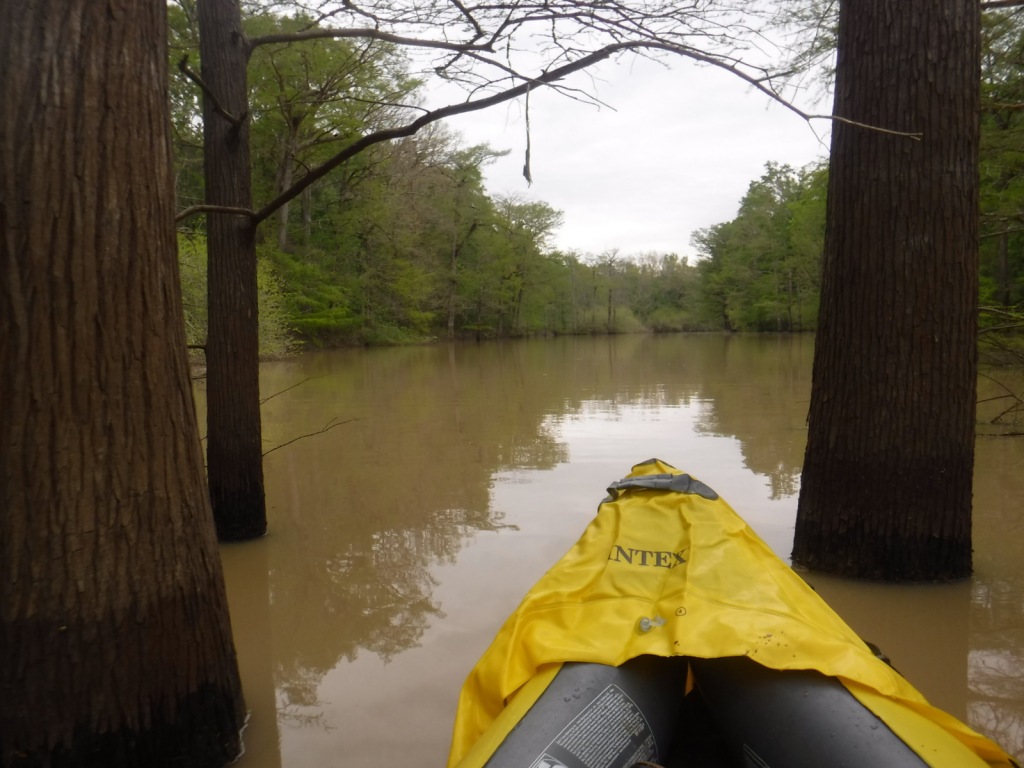
Delta National Forest has two main developed areas at Blue Lake and the Little Sunflower River, with Blue Lake Nature Trail and Rock Bottom Trail found at these sites respectively.  Both were flooded during our April visit, so in lieu of hiking, we opted to launch our inflatable kayak and paddle around Blue Lake to get up close to some huge baldcypress trees. 

Watchable Wildlife

Declared National Natural Landmarks in 1976, the Green Ash-Overcup Oak-Sweetgum Research Natural Areas are rare examples of pristine bottomland hardwood forests.  To improve wintering waterfowl conditions, three of the five greentree reservoirs are pumped and over 100 acres are planted as wildlife food plots.  Established in 1978, the neighboring Panther Swamp National Wildlife Refuge is one of seven refuges in the Theodore Roosevelt National Wildlife Refuge Complex.  The forest’s white-tailed deer herd is in very good condition, as are the numbers of wild turkeys, fox squirrels, swamp rabbits, river otters, raccoons, and American alligators.  The forest is known for its 32 different species of butterflies that congregate in July, with an average population of 21,000.

Instagram-worthy Photo

Across from Blue Lake on unpaved Fire Tower Road, be sure to stop at the Kay Cypress Tree, which is more than ten feet in diameter.

Peak Season

Winter

Fees

All vehicles in Sunflower Wildlife Management Area must display a free Daily Visitor Use Permit and all ATV, horse, and bike riders must carry a pass (fee) on the multi-use trails. 

Road Conditions

Fire Tower Road is unpaved, but was flat and above floodwater levels during our April visit, as was the road atop the dike along the Little Sunflower River.

Camping

Camping is only allowed at 57 primitive sites with a permit obtainable online ($7 per night fee). 

Wilderness Areas

None

Related Sites

Bienville National Forest (Mississippi)

De Soto National Forest (Mississippi)

Vicksburg National Military Park (Mississippi)

Nearest National Park

Hot Springs

Conifer Tree Species

baldcypress

Flowering Tree Species

Nuttall’s oak, overcup oak, cherrybark oak, willow oak, water oak, bur oak, swamp chestnut oak, water hickory, sweetgum, boxelder, swamp red maple, American elm, green ash, sugarberry, September elm, honeylocust, pecan, black gum, red mulberry, persimmon, deciduous holly, swamp dogwood

Explore More – What was the name of the legendary hunting guide and woodsman who found and tied up the black bear that Teddy Roosevelt refused to shoot in 1902?

Learn more about this and the 154 other National Forests in our new guidebook Out in the Woods

We are a participant in the Amazon Services LLC Associates Program, an affiliate advertising program designed to provide a means for us to earn fees by linking to Amazon.com and affiliated sites.

Chippewa National Forest

Chippewa National Forest

Minnesota

Managed by U.S. Forest Service, Northeastern Region

1,599,664 acres (666,623 federal/ 933,041 other)

Website: https://www.fs.usda.gov/chippewa

Overview

Following passage of the Morris Act in 1902, the Minnesota Forest Reserve was created from 200,000 acres of unallotted lands on Ojibwe Indian reservations.  It was renamed Chippewa National Forest in 1928 and 44% of its acreage remains part of the Leech Lake Indian Reservation.  The forest includes 1,300 lakes and ponds, 925 miles of rivers, and 440,000 acres of wetlands, which represents 13% of all surface water within the entire National Forest system and provides habitat for a variety of wildlife.  Three of the ten largest lakes in Minnesota are located here: Lake Winnibigoshish, Cass Lake, and Leech Lake.

Highlights

Edge of the Wilderness Scenic Byway, Avenue of Pines Scenic Byway, Lady Slipper Scenic Byway, Woodtick Auto Trail, Cass Lake, Camp Rabideau, Lake Winnibigoshish, Benjamin Lake, Norway Beach Recreation Area, Leech Lake, Lost 40 Natural Area, Heartland Bike Trail, Simpson Creek Trail, Cut Foot Sioux National Recreation Trail, Big Pine Forest Trail, Chippewa Adventure Trail, North Country National Scenic Trail

Must-Do Activity

Other than getting out on the water, a great way to explore Chippewa National Forest is by driving one of five designated Scenic Byways: Lake Country, Edge of the Wilderness, Avenue of Pines, Lady Slipper, and the Great River Road.  Chippewa National Forest has more than 3,000 archeological and historic sites, including Camp Rabideau, perhaps the best preserved Civilian Conservation Corps (CCC) camp left from the 1930s.  Free guided tours of the camp are offered in summer, or you can take a self-guided tour around the well-signed buildings during daylight hours.

Best Trail

The Lost 40 is 144 acres of old-growth red and white pine forest that was never logged due to a surveying error that mapped the area as part of Coddington Lake in 1882.  The oldest tree here is more than 250 years old and can be seen on an easy one-mile loop trail with interpretive signs.  There is also an optional 0.2-mile one-way spur to an overlook of Moose Brook.  The trailhead is located east of Blackduck, Minnesota on well-signed back roads and is also popular for snowshoeing in the winter.

Watchable Wildlife

The most vocal and noticeable residents of Chippewa National Forest are its red squirrels, sandhill cranes, and common loons.  Its many rivers and lakes make ideal habitat for its 180 nesting pairs of bald eagles, one of the highest densities in the contiguous U.S.  Rarer wildlife sightings include Canadian lynx, black bears, moose, and trumpeter swans.  Important gamefish include lake trout, smallmouth bass, walleye, northern pike, and muskellunge (muskie). 

Instagram-worthy Photo

The largest red pine in the Lost 40 is 120 feet tall and three feet in diameter.

Peak Season

Summer

Fees

None

Road Conditions

The scenic byways seem to all be paved, but the roads accessing the Lost 40 and Camp Rabideau are unpaved, although well-signed and maintained.

Camping

The National Forest contains 21 developed campgrounds and 68 official dispersed camping locations. 

Wilderness Areas

None

Related Sites

Grand Portage National Monument (Minnesota)

Mississippi National River and Recreation Area (Minnesota)

Superior National Forest (Minnesota)

Nearest National Park

Voyageurs

Conifer Tree Species

northern white-cedar, tamarack, red pine, eastern white pine, jack pine, balsam fir, black spruce, white spruce

Flowering Tree Species

basswood, sugar maple, red maple, northern red oak, bur oak, basswood, American elm, slippery elm, bog birch, yellow birch, paper birch, bigtooth aspen, quaking aspen, balsam poplar

Explore More – The Lost 40 grows on an esker (or glacial ridge); how many years ago did the esker form?

Learn more about Chippewa and the 154 other National Forests in our new guidebook Out in the Woods

We are a participant in the Amazon Services LLC Associates Program, an affiliate advertising program designed to provide a means for us to earn fees by linking to Amazon.com and affiliated sites.