Tag Archives: history

Scotts Bluff National Monument

Scotts Bluff National Monument

Nebraska

Managed by National Park Service

Established 1919

3,005 acres

Website: nps.gov/scbl

Overview

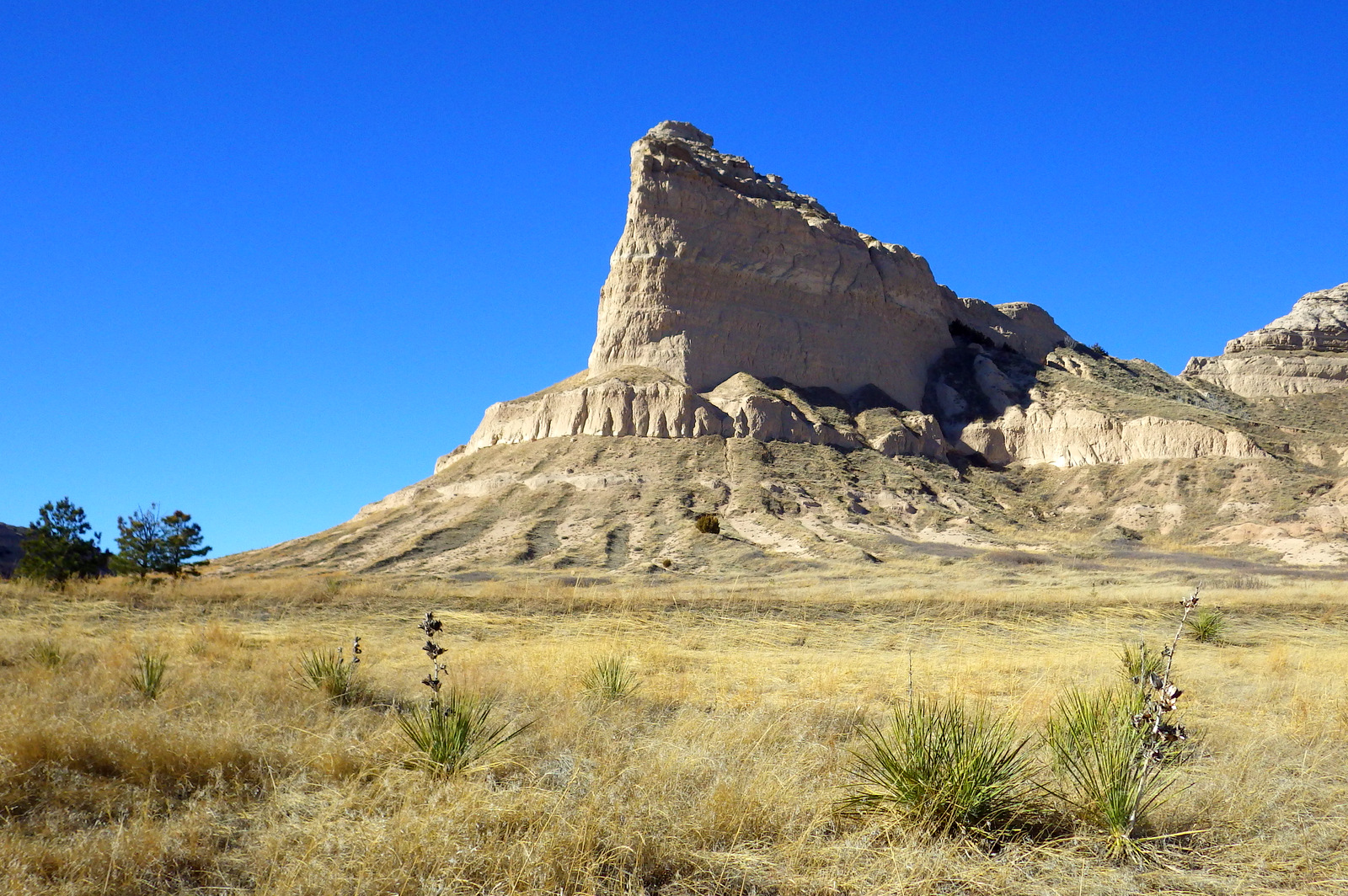
If the names of Scotts Bluff and Chimney Rock sound familiar, it is perhaps because you grew up playing The Oregon Trail computer game on a Macintosh in the early 1990s.  The massive 800-foot tall sandstone cliffs enclosed within Scotts Bluff National Monument were once the unofficial one-third mark along the historic trail, as well as a landmark along the California Trail, the Mormon Pioneer Trail, and the short-lived Pony Express Trail.

Know someone who loves exploring new National Monuments? Gift them our book Monumental America: Your Guide to All 138 National Monuments that is available for sale on Amazon.com.

Echo at Scotts Bluff

Highlights

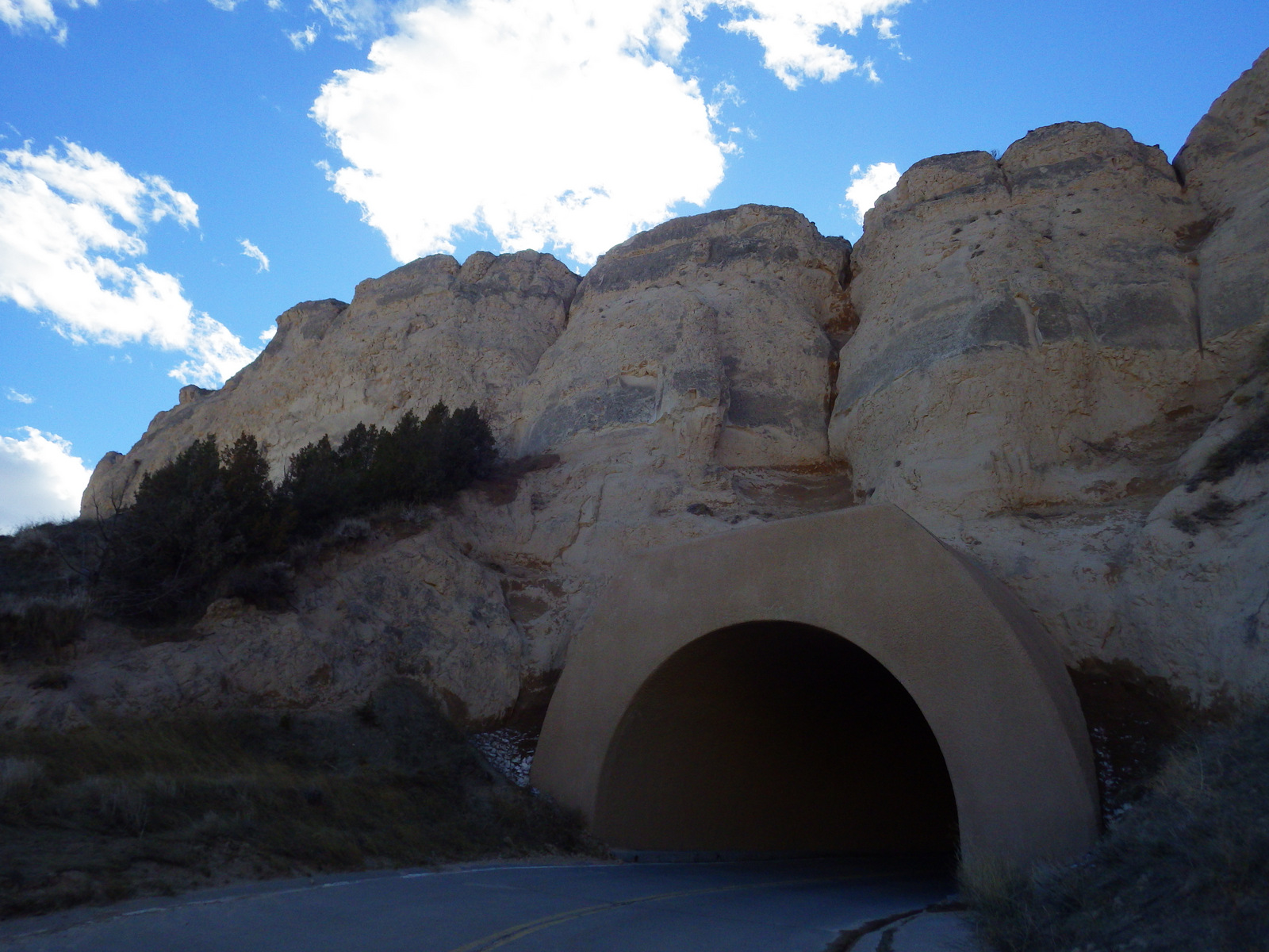
Museum, vistas, historic trail, only road tunnels in Nebraska

Must-Do Activity

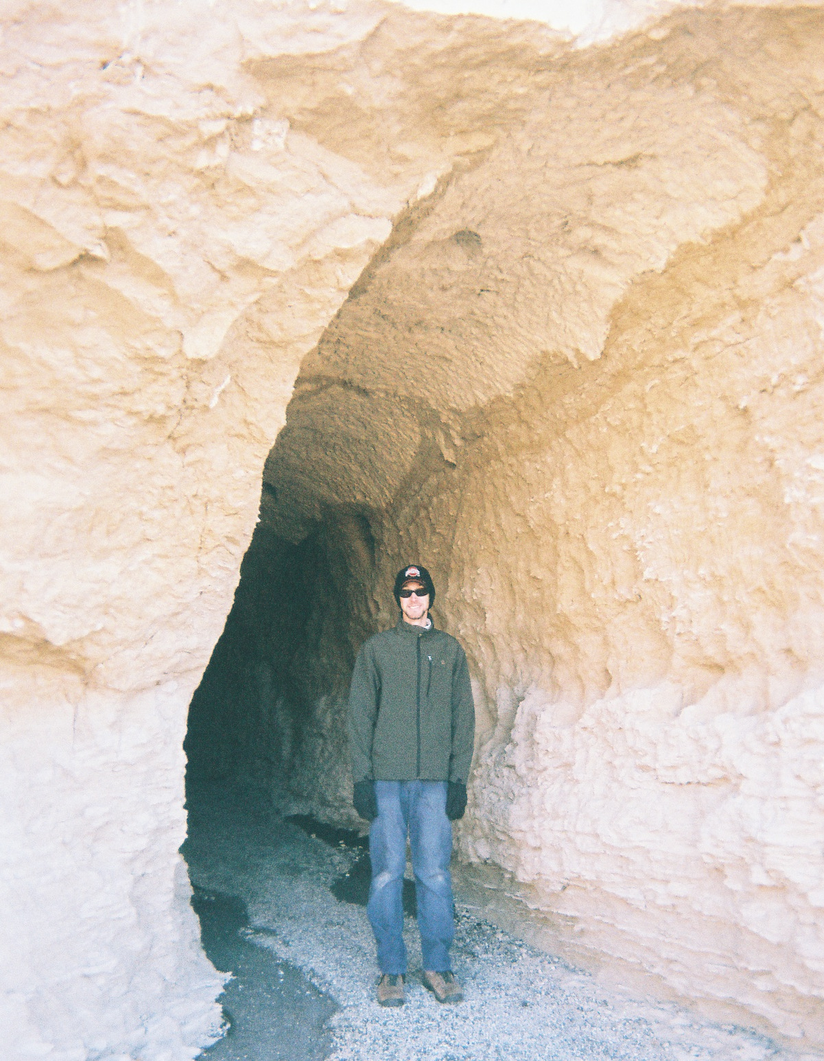
While we recommend the hike to the top from the visitor center, you should probably also drive up there, because these are the only three tunnels dug for a road in the entire state of Nebraska.

Best Trail

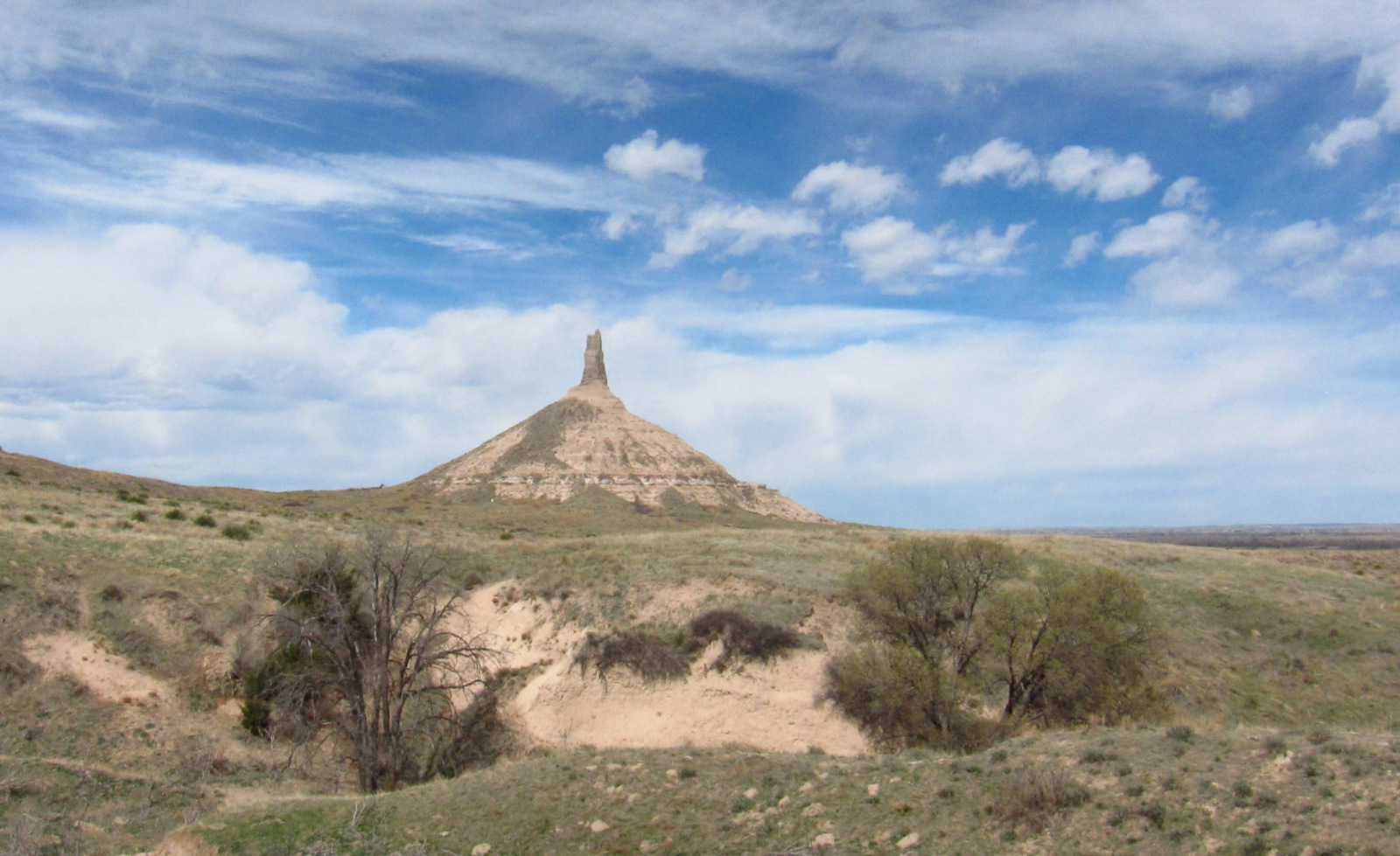
Saddle Rock Trail leads from the parking lot at the visitor center 1.6-miles up the 800-foot tall bluff through a tunnel carved in the sandstone for great views of distant Chimney Rock National Historic Site (an affiliated NPS unit), another prominent Nebraska landform noted by early emigrants.

Instagram-worthy Photo

Pose with the oxen sculptures pulling a wagon up Mitchell Pass in front of Scotts Bluff.

Where the Oregon Trail went

Peak Season

Summer (watch for prairie rattlesnakes)

Hours

https://www.nps.gov/scbl/planyourvisit/hours.htm

Fees

$5 per vehicle or America the Beautiful pass

Road Conditions

All roads paved

Camping

There is not a campground within the monument, but the adjacent cities of Scottsbluff and Gering have RV parks and dispersed camping is available in Nebraska National Forest.

Related Sites

Agate Fossil Beds National Monument (Nebraska)

Jewel Cave National Monument (South Dakota)

Badlands National Park (South Dakota)

Nearest National Park

Wind Cave

You can also drive to the top (there are three tunnels)
The only road tunnels in Nebraska are in this National Monument.
4-February 2015 341
1-March 2018 079
The trail on top of Scotts Bluff.
5-February 2015 350
Enjoy views of Scottsbluff, Nebraska and the North Platte River from atop the cliffs.
8-R1-06216-019A
Scott in the tunnel on Saddle Rock Trail.
3-April 2017 025
Drive east to Chimney Rock National Historic Site for another Nebraska landmark on the Oregon Trail.

Explore More – Did the U.S. Army abandon Fort Mitchell before or after completion of the transcontinental railroad?

Learn more about the other 137 National Monuments in our book Monumental America: Your Guide to All 138 National Monuments

Big Hole National Battlefield

Overview

Big Hole National Battlefield is located in southwestern Montana, part of the larger Nez Perce National Historical Park, which spans four states.  Back in 1877, following violent clashes with white settlers, five bands of the Nez Perce tribe left the Wallowa Valley of Oregon and were followed east by the U.S. Army.  After the remaining 800 Nez Perce went over the mountains bypassing an Army blockade at Lolo Pass, they stopped to rest in the Big Hole Valley.  A surprise attack by the U.S. Army on the morning of August 9, 1877 led to bloodshed on both sides, with Nez Perce warriors forcing the troops to retreat, capturing a Howitzer cannon, and allowing their women and children to escape towards Yellowstone National Park.

Big Hole

Highlights

Overlook from visitor center, interpretive film, trail to site of Nez Perce Camp

Must-Do Activity

Start at the visitor center for the 26-minute film and an overview of the battlefield.  You are in for a treat if you happen to be around for a presentation by Dr. Bob Brown acting as Major Charles Rawn to describe his historic connection with the site.

Best Trail

The National Park Service visitor center overlooks the battlefield for orientation, and a paved road leads down to a trailhead to access the site of the attack (Nez Perce Camp), and a more strenuous climb to the Siege Area, army trenches, and the Howitzer capture site.  Interpretive booklets are available for only $1.00.

Instagram-worthy Photo

Montana is known for its Big Sky, which can be quite beautiful when pierced by the tale teepee poles set up at the site of the Nez Perce camp.

August 2018 299

Peak Season

Open year round, but winters are long and snowy in this part of Montana, making summer the best time to visit.

Hours

https://www.nps.gov/biho/planyourvisit/hours.htm

Fees

None

Road Conditions

All roads are paved and the Nez Perce Camp Trail is wide and flat enough to allow for wheelchairs.

Camping

None in the park, but campgrounds and dispersed camping can be found in nearby Beaverhead-Deer Lodge National Forest.

August 2018 273
This monument was erected where U.S. Army troops were pinned down by sniper fire and dug trenches that are still visible today.

August 2018 282
The North Fork of the Big Hole River runs through the battlefield.

August 2018 263
The Howitzer capture site is at the end of a steep hike with great views.

August 2018 285

Explore More – How long was the journey between Wallowa Lake, Oregon and Bear Paw Battlefield in northeastern Montana where 432 Nez Perce were finally captured?

1WonsTiny

WONDON WAS HERE

Vicksburg National Military Park

Overview

During the Civil War, control of the Mississippi River was “the key” (in President Abraham Lincoln’s words) to preserving the Union by dividing the Confederacy and limiting its supply movement.  By 1862, Vicksburg and Port Hudson were the only fortifications not under U.S. control.  The numerous failed attempts to take Vicksburg by force are evidenced by the 17,000 soldiers buried in the National Cemetery here.  Following a 46-day bombardment, the city finally surrendered on July 4, 1863.

Vicksburg

Highlights

USS Cairo ironside ship, museums, 1,330 monuments, interpretive film

Must-Do Activity

The most fascinating exhibit in the park is the partially reconstructed USS Cairo, an ironclad gunboat which was carefully salvaged from the Yazoo River during the 1960s.

Best Trail

There are a few short trails with interpretive panels, but instead you might consider hiring a licensed guide to ride along with you for 2 hours on the auto tour.

Instagram-worthy Photo

Gates close precisely at 5 p.m. for the 16-mile auto tour, but the end of the day provides the best lighting on the Shirley House, the only surviving structure inside the park from the time of the Civil War.

The only house still standing from 1863

Peak Season

The weather is nicest in spring and fall

Hours

https://www.nps.gov/vick/planyourvisit/basicinfo.htm

Fees

$20 per vehicle or America the Beautiful pass

Road Conditions

All roads paved

Camping

27 miles to the south, the National Park Service runs the Rocky Springs Campground (with running water) on the Natchez Trace Parkway.

Sunset over the battlefield

imgp1788.jpg

Tiff on steps of Illinois Memorial
The Illinois Memorial is the largest of approximately 1,330 located inside the park.

Mural of Illinois Memorial dedication day
A mural along the Mississippi River depicts the opening day for the Illinois Memorial

Scott with USS Cairo
USS Cairo is a well-preserved specimen of an ironclad ship, and the museum next door displays thousands of its artifacts.

Tiff with cannon

IMG_9964IMG_9970IMG_9973

Explore More – Why did many residents flee their houses to live inside hand-dug caves during the Civil War?

1WonsTiny2

WONDON WAS HERE

We are a participant in the Amazon Services LLC Associates Program, an affiliate advertising program designed to provide a means for us to earn fees by linking to Amazon.com and affiliated sites.

Grand Portage National Monument

Overview

Beaver fur top hats were a must-have fashion accessory for every wealthy man in Europe and America in the late 1700s.  To access the trapping grounds to the west, it was necessary for the French-Canadian voyageurs to walk their canoes along an 8 mile portage to bypass the rapids on the Pigeon River.  In 1784, the end of the trail on the edge of Lake Superior became the site of the North West Company headquarters where they held an annual Rendezvous—a giant party and opportunity for trade.

Northwoods 2013 600

Highlights

Reconstructed fort, Ojibwa village, living history demonstrations, Rendezvous Days every August

Must-Do Activity

Walk around the reconstructed buildings and talk with the costumed reenactors that demonstrate canoe building, bread baking, weapons firing, and other activities during the summer.

Best Trail

Day hikers and backpackers can follow the historic Grand Portage Trail 8.5 miles one-way along the Pigeon River to the former site of Fort Charlotte.  The 300 foot climb to the top of Mt. Rose is also popular for views of Lake Superior.

Instagram-worthy Photo

The reconstructed North West Company headquarters buildings have wonderfully warped glass panes which are fun to take photographs through.

Northwoods 2013 612

Peak Season

Summer

Hours

https://www.nps.gov/grpo/planyourvisit/hours.htm

Fees

None

Road Conditions

All roads to the monument are paved, but Partridge Falls Road offers four-wheel drive opportunities.

Camping

The only camping inside the park are two backpacking sites at Fort Charlotte available with a free permit.  Most people waiting to catch the morning ferry to Isle Royale National Park camp at Grand Portage Casino right on Lake Superior or 20 miles south at Judge Magney State Park.

Northwoods 2013 622

Northwoods 2013 589

Northwoods 2013 592


Northwoods 2013 604

Northwoods 2013 603

Northwoods 2013 614

Explore More – After hat fashion changed to silk instead of beaver, when was the portage abandoned?

1WonsTiny2

WONDON WAS HERE

Lowell National Historical Park 

Overview

Built in the 1820s, Lowell, Massachusetts took the idea of a mill town and scaled it up to a factory city.  Utilizing the power of the Concord and Merrimack Rivers, its textile mills grew until its population reached 33,000 by 1850.  The workers were primarily immigrants and predominantly women, many of whom were single and lived in boarding houses like the one you can tour today in Lowell National Historical Park.

Lowell.JPG

Highlights

Mill Girls and Immigrants Exhibit, Boot Cotton Mills Museum, canal boat tours, Lower Locks, Jack Kerouac Commemorative Park

Must-Do Activity

It is worth the entry fee to go inside Boott Cotton Mills Museum to hear, feel, and see early-1900s machines still running and learn more about the manufacturing process, living conditions, and labor unrest.

Best Trail

Not a traditional trail, but it is a short walk along the historic canals from the NPS Visitor Center to Boott Cotton Mills Museum, the Lower Locks, and the Commemorative Park to author Jack Kerouac.

Instagram-worthy Photo

Hand dug canals from the Concord and Merrimack Rivers powered the Lower Locks in downtown Lowell.

A dam on the canal system in Lowell

Peak Season

Summer

Hours

https://www.nps.gov/lowe/planyourvisit/hours.htm

Fees

None for most sites and NPS Visitor Center (free parking there), but Boott Cotton Mills Museum charges $6 per adult for admission (discount with America the Beautiful pass).

Road Conditions

All roads paved

Camping

Harold Parker State Forest has a campground open in summer 13 miles east of Lowell.

imgp1484.jpg

A mill at Lowell

Mill reflections

Tiff in the room with all the looms - she was loving it
Feel the power of these loud machines in action inside Boott Cotton Mills Museum.

IMGP1470

The detail on the model was quite extraordinary

Kerowac's typewriter
There are a few artifacts from the life of hometown hero Jack Kerouac whose books inspired the Beat Generation.

Explore More – How did the “kiss of death” slowly kill many textile workers?

1WonsTiny2

WONDON WAS HERE

We are a participant in the Amazon Services LLC Associates Program, an affiliate advertising program designed to provide a means for us to earn fees by linking to Amazon.com and affiliated sites.