Tag Archives: city

World War II Memorial

Overview

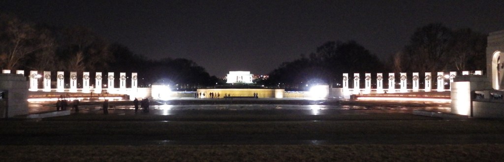
The World War II Memorial in Washington, D.C. was dedicated in 2004 to remember the 16-million Americans that served in uniform during the war.  It is located on the National Mall between the Washington Monument and Lincoln Memorial.  The seven-acre site is managed by the National Park Service (NPS).  There is not an NPS visitor center at the site, but there are information kiosks around the area, including two near the Lincoln Memorial.

Highlights

Pavilions, pillars, bas-relief sculptures, fountains

Must-Do Activity

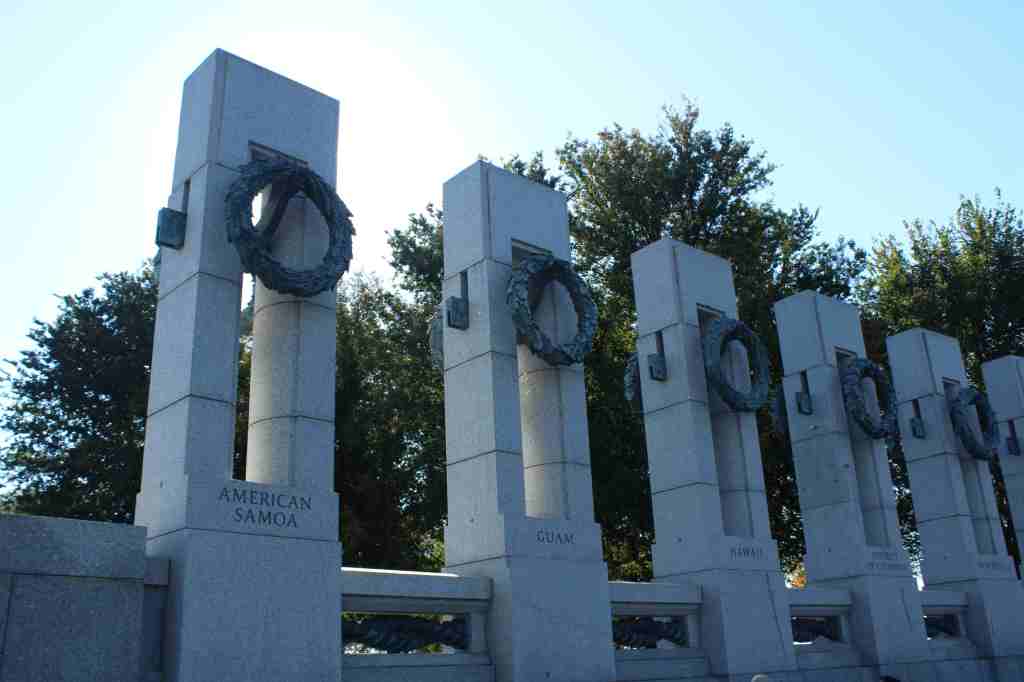
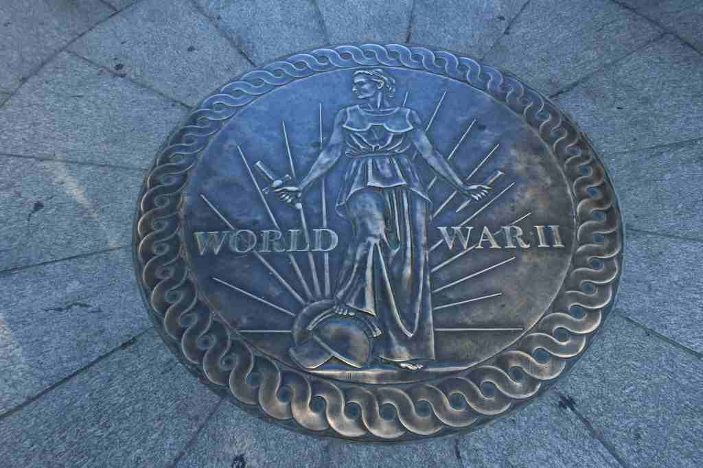
The memorial’s design was chosen in a competition with more than 400 others and was created in 1997 by Austrian-born architect Friedrich St. Florian.  It features a large pool and fountains, two pavilions labeled Atlantic and Pacific, 56 pillars for each state and territory, as well as bas-relief sculptures and quotes from historic figures.  On the Freedom Wall, each gold star represents one hundred of the 405,399 Americans who died during World War II.

Best Trail

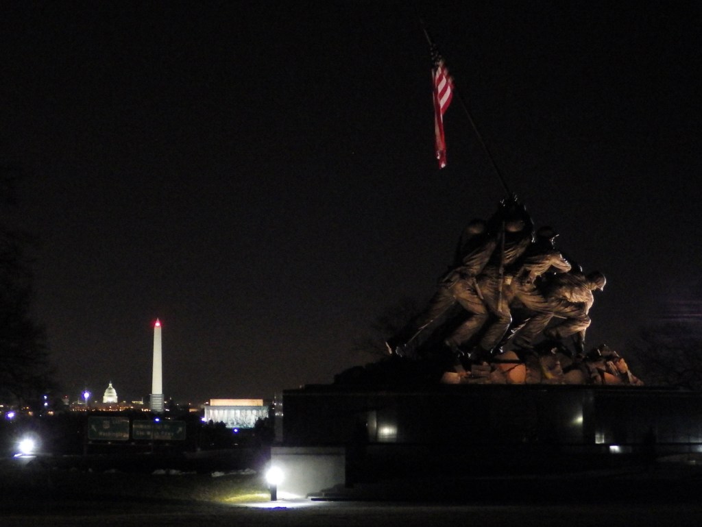
Walk the bridge across the Potomac River to Arlington, Virginia for a view of the U.S. Marine Corps War Memorial that depicts the American flag being raised over Mount Suribachi on Iwo Jima during World War II.  This is technically part of George Washington Memorial Parkway (another NPS site), and offers a commanding view of the National Mall and is especially photogenic at night.

Instagram-worthy Photo

After dark is a great time for photography on the National Mall, and the World War II Memorial is no exception.  You might consider bringing a tripod for clearer photos.

Peak Season

Spring

Hours

24 hours a day with NPS rangers posted until 10 p.m.

https://www.nps.gov/wwii/planyourvisit/hours.htm

Fees

None

Road Conditions

All roads are paved, but public transportation is recommended in Washington, D.C.

Camping

There are no NPS campgrounds in the Washington, D.C., so it might be best to head for Shenandoah National Park in Virginia.

Related Sites

World War I Memorial (District of Columbia)

Franklin Delano Roosevelt Memorial (District of Columbia)

Korean War Veterans Memorial (District of Columbia)

Explore More – The memorial contains two hidden “Kilroy was here” engravings; what is the significance of this inclusion?

.

Kennesaw Mountain National Battlefield Park

Overview

There are probably not many places on the list of top 50 most visited units in the National Park Service (NPS) system that you have never heard of, but Kennesaw Mountain National Battlefield Park may be one.  Located in a suburb of Atlanta, Georgia, this 2,923-acre park receives more than 2.3-million visitors annually.  The park memorializes a Civil War battlefield on General Sherman’s “scorched earth” march to Atlanta in 1864 and is now surrounded by a heavily-populated suburb and a university.  Watch for pedestrians on the road to the top of the 700-foot tall Kennesaw Mountain.

Highlights

Museum, film, scenic views, hiking trails, Kolb’s Farm, cannons

Must-Do Activity

You can drive to the cannons and earthworks on top of Kennesaw Mountain when the shuttle bus is not running on weekdays, but most recreationists walk the road or trails to get there.  Inside the NPS visitor center at the 700-foot hill’s base, you will learn about the Atlanta Campaign of 1864 when Union General William Tecumseh Sherman led 100,000 troops out of Chattanooga, Tennessee on the “March to the Sea.”  After 5,350 soldiers died at Kennesaw Mountain, he decided to just go around it on his way to the city, causing the Confederates to abandon their fortifications there.  If you do drive to the top, you will need to go around many pedestrians and bikers, too.

Best Trail

There are 19.7 miles of hiking trails, but we found that most visitors just walked or biked down the center of the paved road to the top.

Instagram-worthy Photo

Kennesaw Mountain offers sweeping views of the Atlanta-metropolitan area.

Peak Season

Spring and fall

Hours

https://www.nps.gov/kemo/planyourvisit/hours.htm

Fees

$5 per vehicle or America the Beautiful pass

Road Conditions

The road to the top is paved, but there is limited parking up there so a shuttle bus runs on weekends.

Camping

There are several campgrounds on nearby Lake Altoona managed by the U.S. Army Corps of Engineers.  Red Top Mountain State Park is also located north of Kennesaw, Georgia.

Related Sites

Chickamauga and Chattanooga National Military Park (Tennessee-Georgia)

Chattahoochee River National Recreation Area (Georgia)

Andersonville National Historic Site (Georgia)

Explore More – The attack on Kennesaw Mountain occurred on June 27, 1864, but when did the Union army finally occupy Atlanta?

Castillo de San Marcos National Monument

Overview

Established in 1565, St. Augustine, Florida is the oldest permanent European settlement in the continental U.S.  Its centerpiece is Castillo de San Marcos National Monument, a four-sided stone fort dating back to 1672.  In 1702, the British army unsuccessfully besieged the Spanish fort for 50 days, but before they left they burned the entire city.  This explains why the oldest house in St. Augustine dates to this time period and why this charming coastal village is still laid out on a grid of narrow streets, as it was one of the first master-planned communities in America.

Highlights

Historic fort, museum, cannon demonstrations

Must-Do Activity

The National Park Service (NPS) charges an admission fee to enter the fort, but you can watch the cannon-firing demonstrations atop its corner bastion for free from outside.  Costumed reenactors shout orders in Spanish before firing the big cannon.  There is only one entrance to the Castillo de San Marcos across a wide moat.  Your entrance fee also allows you to explore the powder magazines and interpretive displays inside the fort’s walls.

Best Trail

None

Instagram-worthy Photo

The Castillo was renamed Fort Marion by the U.S. military in 1825, when the final changes were made to the coquina structure.  In 1924 it was named a National Monument along with nearby Fort Matanzas.

Peak Season

Winter

Hours

https://www.nps.gov/casa/planyourvisit/hours.htm

Fees

$15 per person or America the Beautiful pass

Road Conditions

Roads are paved, but there is limited pay parking at the fort, which is especially an issue on busy weekends.

Camping

Anastasia State Park is located just south of St. Augustine, Florida with access to a nice beach.

Related Sites

Fort Caroline National Memorial (Florida)

Fort Matanzas National Monument (Florida)

Dry Tortugas National Park (Florida)

Explore More – Which nation controlled the fort during the American Revolution until its conclusion in 1783 (Hint: It was called Fort St. Mark at the time)?

Fort Smith National Historic Site

Overview

Along a segment of the Arkansas River serving as a border with Oklahoma, Fort Smith is a lovely 35-acre park surrounded by a bustling downtown and busy railroad track.  The first fort at this site was established in 1817 to assist in the Cherokee relocation at the end of the Trail of Tears.  A second fort was built nearby in 1838, occupied by both sides during the Civil War, then closed in 1871 when it became a Federal Court.

Highlights

Museum, restored courtroom, “Hell-on-the-Border” jail, Arkansas River

Must-Do Activity

The exhibits here demonstrate the harsh prison conditions and tell harrowing stories of frontier life that will make you cringe.  Do not miss the “Hell-on-the-Border” jail in the basement and the restored courtroom.  Outside, a reproduction of the gallows and several cannon emplacements provide a counterpoint to the idyllic riverfront setting. 

Best Trail

A half-mile trail crosses the railroad tracks to the banks of the Arkansas River.  The scenic beauty of the shoreline at sunset belies the turbulent history of this place, including its connection with the Trail of Tears, designated a National Historic Trail.

Instagram-worthy Photo

Take a photo in the painstakingly restored courtroom where Judge Isaac C. Parker heard 12,000 criminal cases during his 21 years on the bench in the late 1800s.  He sentenced 160 persons to hang, and 79 executions took place right here at Fort Smith.

Peak Season

Spring and fall

Hours

https://www.nps.gov/fosm/planyourvisit/hours.htm

Fees

$10 per person or America the Beautiful pass

Road Conditions

All roads are paved and there is free parking on site.

Camping

Two miles north of Barling, Arkansas, the U.S. Army Corps of Engineers manages a campground on the Arkansas River.

Related Sites

Arkansas Post National Memorial (Arkansas)

Fort Scott National Historic Site (Kansas)

Pea Ridge National Military Park (Arkansas)

Explore More – Fort Smith was established in 1817 to assist in the Cherokee relocation at the end of the Trail of Tears, but what American Indian tribe already inhabited this region?

Tule Springs Fossil Beds National Monument

Following meetings in regards to development in North Las Vegas, the Protectors of Tule Springs was founded in 2006 and successfully preserved 22,650 acres of federal land eight years later.  The area contains fossils of Columbian mammoths, ground sloths, American lions, ancient camels, dire wolves, sabre-toothed cats, bison, and three ancient species of horse ranging from 7,000- to 250,000-years-old.  There are plans to open a National Park Service (NPS) visitor center at the end of Aliante Parkway.

Highlights

Upper Las Vegas Wash, natural bridge, trash cleanup

Must-Do Activity

The actual Tule Springs are a desert oasis contained within Floyd Lamb Park, operated by the City of Las Vegas.  The Bureau of Land Management formerly controlled the acreage that became the National Monument and it was heavily impacted by garbage dumping, off-road driving, and shooting.  Your “must-do activity” here is to remove some trash.  The Protectors of Tule Springs have hosted several cleanup events.

Best Trail

There are no trails within the National Monument yet, but there are two access points to Upper Las Vegas Wash from Durango Drive and Aliante Parkway.  The wash contains Joshua trees and several patches of the rare Las Vegas bear poppy, and provides habitat for threatened desert tortoises, burrowing owls, and kit foxes.

Instagram-worthy Photo

Hike the Upper Las Vegas Wash about a half-mile east from the end of Durango Drive and look for a natural bridge carved in the soft mudstone wall. 

Peak Season

Winter when snow dusts the top of the Sheep Range and Las Vegas Range of mountains.

Hours

Tule Springs Fossil Beds National Monument is open sunrise to sunset.  Information is available at visitor centers in Lake Mead National Recreation Area. https://www.nps.gov/tusk/planyourvisit/hours.htm

Fees

None

Road Conditions

Roads are paved to access points at the north end of Durango Drive and at the end of Aliante Parkway.  Look for wire barriers and small brown NPS signs at the two parking areas.

Camping

None within the National Monument, but free dispersed camping is allowed within Desert National Wildlife Refuge to the north.  There are campgrounds in nearby Humboldt-Toiyabe National Forest and Lake Mead National Recreation Area.

Explore More – In what year did National Geographic conduct a 4-month study here to catalog thousands of Ice Age mammal fossils?