Big Hole National Battlefield

Overview

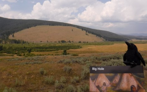
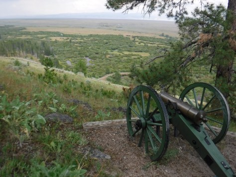
Big Hole National Battlefield is located in southwestern Montana, part of the larger Nez Perce National Historical Park, which spans four states.  Back in 1877, following violent clashes with white settlers, five bands of the Nez Perce tribe left the Wallowa Valley of Oregon and were followed east by the U.S. Army.  After the remaining 800 Nez Perce went over the mountains bypassing an Army blockade at Lolo Pass, they stopped to rest in the Big Hole Valley.  A surprise attack by the U.S. Army on the morning of August 9, 1877 led to bloodshed on both sides, with Nez Perce warriors forcing the troops to retreat, capturing a Howitzer cannon, and allowing their women and children to escape towards Yellowstone National Park.

Big Hole

Highlights

Overlook from visitor center, interpretive film, trail to site of Nez Perce Camp

Must-Do Activity

Start at the visitor center for the 26-minute film and an overview of the battlefield.  You are in for a treat if you happen to be around for a presentation by Dr. Bob Brown acting as Major Charles Rawn to describe his historic connection with the site.

Best Trail

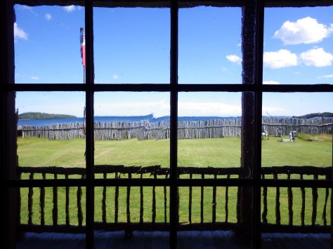
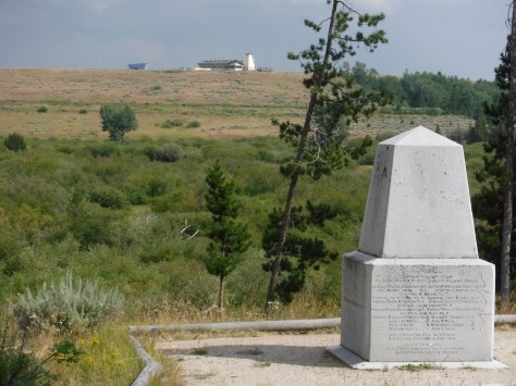
The National Park Service visitor center overlooks the battlefield for orientation, and a paved road leads down to a trailhead to access the site of the attack (Nez Perce Camp), and a more strenuous climb to the Siege Area, army trenches, and the Howitzer capture site.  Interpretive booklets are available for only $1.00.

Instagram-worthy Photo

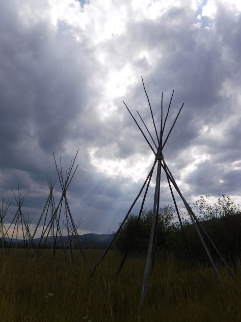
Montana is known for its Big Sky, which can be quite beautiful when pierced by the tale teepee poles set up at the site of the Nez Perce camp.

August 2018 299

Peak Season

Open year round, but winters are long and snowy in this part of Montana, making summer the best time to visit.

Hours

https://www.nps.gov/biho/planyourvisit/hours.htm

Fees

None

Road Conditions

All roads are paved and the Nez Perce Camp Trail is wide and flat enough to allow for wheelchairs.

Camping

None in the park, but campgrounds and dispersed camping can be found in nearby Beaverhead-Deer Lodge National Forest.

August 2018 273
This monument was erected where U.S. Army troops were pinned down by sniper fire and dug trenches that are still visible today.
August 2018 282
The North Fork of the Big Hole River runs through the battlefield.
August 2018 263
The Howitzer capture site is at the end of a steep hike with great views.

August 2018 285

Explore More – How long was the journey between Wallowa Lake, Oregon and Bear Paw Battlefield in northeastern Montana where 432 Nez Perce were finally captured?

1WonsTiny

WONDON WAS HERE

Ozark National Scenic Riverways

Overview

North of Arkansas’ Buffalo National River on the Ozark Plateau is Ozark National Scenic Riverways, perhaps the wildest section of Missouri.  Unlike the many reservoirs around Branson, here the Current and Jacks Fork Rivers flow freely and have been managed by the National Park Service since 1964.  The best way to explore the serpentine park boundaries is on the water, but roads and trails access several areas.

Ozark

Highlights

Canoeing/kayaking, Blue Spring, Alley Mill, karst landforms and caves

Must-Do Activity

The crystal clear spring-fed water of the Jack’s Fork River is home to a variety of fish, birds, and even the occasional beaver.  We paddled 25 miles from Buck Hollow to Alley Spring, a pleasant day trip.

Best Trail

The dolomite and limestone karst underneath this park is riddled with caves and sinkholes, like Devils Well, Round Spring Cave (ranger guided tours for a fee), and Jam Up Cave (only accessible from the Jack’s Fork River).

Instagram-worthy Photo

Hike to 310-foot deep Blue Spring (which was aptly called Spring of the Summer Sky by Native Americans) or drive to the bright red Alley Mill that dates back to 1894.

Cool shadows

Peak Season

Spring offers peak water flows for canoeing/kayaking

Hours

https://www.nps.gov/ozar/planyourvisit/basicinfo.htm

Fees

None, but you can pay local concessionaires to rent canoes and shuttle your vehicle.

Road Conditions

Highways are paved and most dirt roads are narrow but passable with a passenger vehicle when dry

Camping

There are many campgrounds within Ozark National Scenic Riverways, some with full RV hookups and some primitive (we especially liked Bay Creek).  Floaters on the Current and Jacks Fork Rivers are allowed to camp on gravel bars.

Tiff in Bananas Trace

Scott at the opening to Jam Up cave
Jam Up Cave is only accessible by beaching your boat along the Jacks Fork River.  Find this photo and others for sale on Imagekind

Wading in the water

A great blue heron taking off

More bluffs

Scott with the source of Blue Spring
Scott at Blue Spring

Explore More – The colorful Blue Spring pumps out how many million gallons of water per day?

1WonsTiny2

WONDON WAS HERE

We are a participant in the Amazon Services LLC Associates Program, an affiliate advertising program designed to provide a means for us to earn fees by linking to Amazon.com and affiliated sites.

Vicksburg National Military Park

Overview

During the Civil War, control of the Mississippi River was “the key” (in President Abraham Lincoln’s words) to preserving the Union by dividing the Confederacy and limiting its supply movement.  By 1862, Vicksburg and Port Hudson were the only fortifications not under U.S. control.  The numerous failed attempts to take Vicksburg by force are evidenced by the 17,000 soldiers buried in the National Cemetery here.  Following a 46-day bombardment, the city finally surrendered on July 4, 1863.

Vicksburg

Highlights

USS Cairo ironside ship, museums, 1,330 monuments, interpretive film

Must-Do Activity

The most fascinating exhibit in the park is the partially reconstructed USS Cairo, an ironclad gunboat which was carefully salvaged from the Yazoo River during the 1960s.

Best Trail

There are a few short trails with interpretive panels, but instead you might consider hiring a licensed guide to ride along with you for 2 hours on the auto tour.

Instagram-worthy Photo

Gates close precisely at 5 p.m. for the 16-mile auto tour, but the end of the day provides the best lighting on the Shirley House, the only surviving structure inside the park from the time of the Civil War.

The only house still standing from 1863

Peak Season

The weather is nicest in spring and fall

Hours

https://www.nps.gov/vick/planyourvisit/basicinfo.htm

Fees

$20 per vehicle or America the Beautiful pass

Road Conditions

All roads paved

Camping

27 miles to the south, the National Park Service runs the Rocky Springs Campground (with running water) on the Natchez Trace Parkway.

Sunset over the battlefield

imgp1788.jpg

Tiff on steps of Illinois Memorial
The Illinois Memorial is the largest of approximately 1,330 located inside the park.
Mural of Illinois Memorial dedication day
A mural along the Mississippi River depicts the opening day for the Illinois Memorial
Scott with USS Cairo
USS Cairo is a well-preserved specimen of an ironclad ship, and the museum next door displays thousands of its artifacts.

Tiff with cannon

IMG_9964IMG_9970IMG_9973

Explore More – Why did many residents flee their houses to live inside hand-dug caves during the Civil War?

1WonsTiny2

WONDON WAS HERE

We are a participant in the Amazon Services LLC Associates Program, an affiliate advertising program designed to provide a means for us to earn fees by linking to Amazon.com and affiliated sites.

Grand Portage National Monument

Overview

Beaver fur top hats were a must-have fashion accessory for every wealthy man in Europe and America in the late 1700s.  To access the trapping grounds to the west, it was necessary for the French-Canadian voyageurs to walk their canoes along an 8 mile portage to bypass the rapids on the Pigeon River.  In 1784, the end of the trail on the edge of Lake Superior became the site of the North West Company headquarters where they held an annual Rendezvous—a giant party and opportunity for trade.

Northwoods 2013 600

Highlights

Reconstructed fort, Ojibwa village, living history demonstrations, Rendezvous Days every August

Must-Do Activity

Walk around the reconstructed buildings and talk with the costumed reenactors that demonstrate canoe building, bread baking, weapons firing, and other activities during the summer.

Best Trail

Day hikers and backpackers can follow the historic Grand Portage Trail 8.5 miles one-way along the Pigeon River to the former site of Fort Charlotte.  The 300 foot climb to the top of Mt. Rose is also popular for views of Lake Superior.

Instagram-worthy Photo

The reconstructed North West Company headquarters buildings have wonderfully warped glass panes which are fun to take photographs through.

Northwoods 2013 612

Peak Season

Summer

Hours

https://www.nps.gov/grpo/planyourvisit/hours.htm

Fees

None

Road Conditions

All roads to the monument are paved, but Partridge Falls Road offers four-wheel drive opportunities.

Camping

The only camping inside the park are two backpacking sites at Fort Charlotte available with a free permit.  Most people waiting to catch the morning ferry to Isle Royale National Park camp at Grand Portage Casino right on Lake Superior or 20 miles south at Judge Magney State Park.

Northwoods 2013 622

Northwoods 2013 589

Northwoods 2013 592


Northwoods 2013 604

Northwoods 2013 603

Northwoods 2013 614

Explore More – After hat fashion changed to silk instead of beaver, when was the portage abandoned?

1WonsTiny2

WONDON WAS HERE

Pictured Rocks National Lakeshore

Overview

The turquoise waters of Lake Superior beneath the sandstone cliffs of Pictured Rocks National Lakeshore make it seem warmer than it actually is.  Glaciers carved this shoreline thousands of years ago, but the Ice Age never seems far off in the lake’s cold waters.  Minerals leaching from the stone paint the cliffs in many hues, hence the name Pictured Rocks.

Pictured

Highlights

Petit Portal, Miners Castle, Munising Falls, Sable Falls

Must-Do Activity

Kayaking through Petit Portal is an unforgettable experience.  Guides can provide the necessary gear and know-how, as well as commercial boat operators that get close to but do not actually pass through the natural arch.

06-IMGP9885

Best Trail

Not far from the visitor center is a short trail to Munising Falls, one of several waterfalls in this 42-mile stretch of shoreline.

Instagram-worthy Photo

It will be hard to maintain a flat horizon line while bobbing on the waves in your kayak as you pass through Petit Portal, so take plenty of pictures.

Peak Season

Primarily a summer destination, but even then be prepared for sudden storms that can suddenly blow across Lake Superior.

Hours

https://www.nps.gov/piro/planyourvisit/hours.htm

Fees

No entry fee, but there is a charge for backcountry camping permits that are only available online.

Road Conditions

All roads are paved (to our knowledge).

Camping

Three campgrounds, plus 14 backcountry camping areas in the National Lakeshore.  More backcountry campsites can be found offshore in Grand Island National Recreation Area, administered by Hiawatha National Forest, which also offers dispersed camping opportunities.

06-IMGP9869

Tiff with the Petit Portal

Colors like Yellowstone

11-IMGP9997

Munising Falls
Munising Falls near the south Visitor Center

Explore More – What valuable mineral stains the sandstone cliffs green and blue?

1WonsTiny2

WONDON WAS HERE


We are a participant in the Amazon Services LLC Associates Program, an affiliate advertising program designed to provide a means for us to earn fees by linking to Amazon.com and affiliated sites.