All posts by Raven About The Parks

Theodore Roosevelt Island National Memorial

Overview

As a strict adherent to his own personal philosophy promoting “the strenuous life,” President Theodore Roosevelt regularly swam in the Potomac River, even in the middle of winter.  As a president with a proud record of conservation (especially in creating National Monuments), it is meaningful that his memorial lies on an 80-acre island with 2.5 miles of gravel trails leading through its beautiful and diverse deciduous forest. 

Highlights

Upland Trail, Swamp Trail, statue

Must-Do Activity

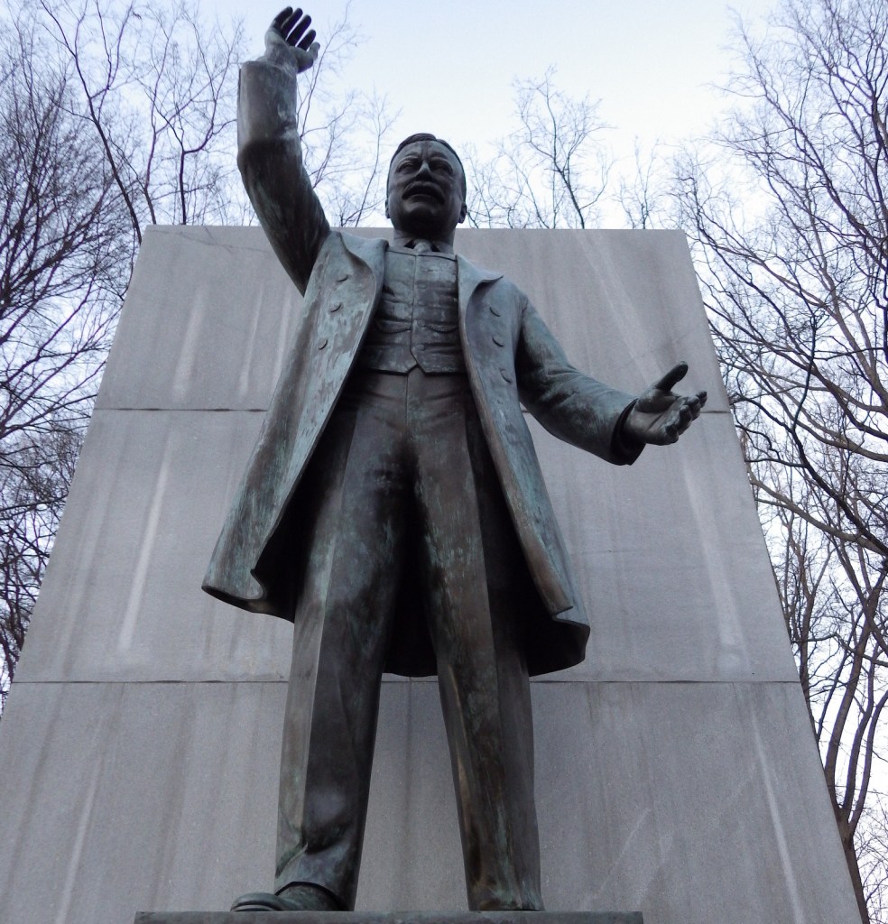
Fittingly, Theodore Roosevelt Island National Memorial is only accessible via a footbridge from the Virginia side of the Potomac River.  Dedicated in 1967, a 17-foot statue of the man is surrounded by several fountains and four monoliths carved with his words.  The foundation of a brick mansion owned by the Mason family in the 1800s can be seen from the trails on the island.

Best Trail

Teddy would surely appreciate that the island is situated along the Mount Vernon Trail, an 18-mile pathway that follows the western bank of the Potomac River.

Instagram-worthy Photo

Teddy Roosevelt was known as a flamboyant orator, which is even captured in his silent statue.  In 1912, he famously gave an 84-minute campaign speech after being shot in the chest by a would-be assassin.

Peak Season

Summer

Hours

https://www.nps.gov/this/planyourvisit/hours.htm

Fees

None

Road Conditions

The parking lot is only accessible from the northbound lanes of the George Washington Memorial Parkway, which is itself a unit of the National Park Service (NPS) system.

Camping

None

Related Sites

George Washington Memorial Parkway (Maryland-Virginia)

Franklin Delano Roosevelt Memorial (District of Columbia)

Rock Creek Park (District of Columbia)

Explore More – When did the Theodore Roosevelt Memorial Association purchase the island?

Top 10 Waterfalls in the National Park Service System

Who doesn’t love a beautiful waterfall?  America’s National Park Service (NPS) sites are full of some of the prettiest examples of flowing water in the world.  A few can be seen from drive-up overlooks, while others require a hike, but they are all worth the effort.  We already ranked the best waterfalls of the 62 National Parks and now are releasing a top 10 list for the other 358 NPS units (click here to see all our Top 10 lists).

10. Lake Chelan National Recreation Area (Washington)

The Cascade Mountains are named for their waterfalls, including Rainbow Falls in Stehekin.

9. Paterson Great Falls National Historical Park (New Jersey)

Unobstructed views of this 77-foot tall waterfall are difficult to find in its urban setting.

8. Buffalo National River (Arkansas)

Hemmed-In-Hollow features a 210-foot tall waterfall, accessible by a long hiking trail or a shorter walk from the river.

7. Mississippi National River and Recreation Area (Minnesota)

St. Anthony Falls is the only true waterfall on the entire river, plus check out the falls in Minnehaha Regional Park.

6. Delaware Water Gap (Pennsylvania-New Jersey)

Raymondskill Falls and Dingmans Falls are located at the end of short hikes in the Poconos.

5. Pictured Rocks National Lakeshore (Michigan)

Short hikes lead to Munising Falls and Sable Falls, or boat to falls along the cliffs of Lake Superior.

4. Niobrara National Scenic River (Nebraska)

Pull ashore on your float down the river to visit waterfalls in Fort Niobrara National Wildlife Refuge and Smith Falls State Park.

3. Whiskeytown-Shasta-Trinity National Recreation Area (California)

Four scenic waterfalls (Whiskeytown, Boulder Creek, Brandy Creek, and Crystal Creek) are accessible by hiking a total of 11 miles.

2. Little River Canyon National Preserve (Alabama)

The wide Little River Falls plunges 45 feet, but Graces High Falls drops 133 feet.

…and finally our #1 waterfall in a National Park Service unit:

1. Devils Postpile National Monument (California)

Rainbow Falls is one of the most picturesque waterfalls in the world, plus check out Minaret Falls.

Honorable Mentions

George Washington Memorial Parkway (Maryland-Virginia)

Great Falls Park on the Potomac River also contains ruins of George Washington’s Patowmack Canal.

Big South Fork National River and Recreation Area (Tennessee-Kentucky)

Yahoo Falls is one of several waterfalls visible within this diverse park.

Lowell National Historical Park (Massachusetts)

It is manmade, but the waterfall created by the Lower Locks in downtown Lowell is still beautiful.

Paterson Great Falls National Historical Park

Overview

A flowing 77-foot waterfall in a narrow 300-foot wide gorge, Paterson Great Falls has long stood out as a natural wonder in New Jersey.  The entire Passaic River drops over this volcanic ridge, making it the second largest waterfall by volume east of the Mississippi River (Niagara Falls is first).  In 1792, the nation’s first Secretary of the Treasury, Alexander Hamilton, founded the City of Paterson to harness this hydropower for manufacturing.  Paterson Great Falls was named a National Natural Landmark in 1966 and a National Historical Park in 2011.

Highlights

Great Falls Historic District Cultural Center, Colt Gun Mill, Overlook Park, Mary Ellen Kramer Park

Must-Do Activity

Start your visit at the Great Falls Historic District Cultural Center, and, if you have time, explore the Paterson Museum (donation requested).  Carefully cross the street to Overlook Park for excellent view of the Great Falls Power Plant, then take the footbridges behind the hydroelectric plant to Mary Ellen Kramer Park for better photographic angles of the waterfall.  Guided tours by park rangers are offered in the summer months.

Best Trail

A walking tour of Paterson, New Jersey continues beyond Mary Ellen Kramer Park to Hinchcliffe Stadium where Negro League Baseball was once played.  On the other side of the Passaic River, follow the river’s raceways to the red-brick ruins of Allied Textile Printing and the Colt Gun Mill.

Instagram-worthy Photo

The Great Falls Power Plant opened in 1914 and still produces enough power to supply 11,000 households.  The “S.U.M. 1791” on the building’s exterior refers to Alexander Hamilton’s Society for Establishing Useful Manufactures.

Peak Season

Summer

Hours

https://www.nps.gov/pagr/planyourvisit/hours.htm

Fees

None

Road Conditions

All roads are paved and there is a free parking lot at Overlook Park.

Camping

None

Related Sites

Lowell National Historical Park (Massachusetts)

Thomas Edison National Historical Park (New Jersey)

Morristown National Historical Park (New Jersey)

Explore More – It cost $14.5-million to refurbish the Great Falls Power Plant in 1986; how much did it cost to build the entire thing in 1914?

Little River Canyon National Preserve

Overview

Authorized in 1992, Little River Canyon National Preserve covers about 14,000 acres in northeast Alabama.  Elevations range from 1,900-foot tall Lookout Mountain down to 650-foot Weiss Lake reservoir, as the Little River plunges from the Cumberland Plateau.  With cliffs up to 600 feet in height, this unique gorge contains several endemic species of plants and animals.  Only the southern half of the preserve is readily accessible by roads, with DeSoto State Park offering the best way to see the northern section.

Highlights

Little River Falls, Canyon Mouth, Graces High Falls

Must-Do Activity

Start your visit at the Little River Canyon Center on Highway 35, then make the short drive to the parking area for 45-foot tall Little River Falls.  From there, drive Highway 176 for 11 miles along the west side of the canyon, which has nine scenic overlooks, including one for seasonal Graces High Falls.

Best Trail

There are a few short trails in the preserve, many of which drop steeply from the rim to the riverside.  At the southern end near the intersection of Highways 273 and 275 is Canyon Mouth, a flat trail that follows alongside the Little River.  There is better hiking and even more waterfalls in nearby DeSoto State Park.

Instagram-worthy Photo

Graces High Falls is 133 feet tall, making it the tallest (aboveground) waterfall in Alabama, but it only flows in the spring and after large rain events.

Peak Season

Spring

Hours

https://www.nps.gov/liri/planyourvisit/hours.htm

Fees

None except at Canyon Mouth ($15 per day or America the Beautiful pass)

Road Conditions

All roads paved

Camping

De Soto State Park offers camping, in addition to excellent hiking trails to several waterfalls.  There are also three backcountry campsites in Little River Canyon National Preserve available from February through September with a permit.

Related Sites

Russell Cave National Monument (Alabama)

Horseshoe Bend National Military Park (Alabama)

Tuskegee Airmen National Historic Site (Alabama)

Explore More – How many endemic species of caddisflies are found in Little River Canyon and nowhere else on Earth?

Grand Teton National Park

Wyoming

Managed by National Park Service

Established 1929

310,000 acres

Website: nps.gov/grte

Overview

Just south of Yellowstone National Park, is one of the most recognizable skylines in the United States, topped by 13,772-foot tall Grand Teton Peak.  The Teton Mountains were established as a National Park in 1929, but the rest of the park has a strange history.  Land in the Jackson Hole valley was bought up by the Rockefeller family and attempted to be donated to the U.S. government for decades.  In 1943, President Franklin D. Roosevelt created Jackson Hole National Monument under the Antiquities Act, but it did not include the Rockefeller holdings.  It was not until 1950 that a deal was struck merging everything into Grand Teton National Park as we know it today.  Part of that negotiation was a requirement that in the future no land in Wyoming would ever be established as a National Monument under the Antiquities Act.

Learn more about how to visit this National Park in the expanded second edition of our guidebook A Park to Yourself: Finding Solitude in America’s 63 National Parks

Highlights

Jenny Lake, Inspiration Point, Jackson Lake Lodge, Oxbow Bend Turnout, Mormon Row

Must-Do Activity

One of our favorite places in the park is Jenny Lake, which sparkles below 12,325-foot Teewinot Peak.  This is the trailhead for Cascade Canyon, but there are plenty of activities other than hiking, which include boating, horseback riding, mountain climbing, whitewater rafting, or cross-country skiing in the winter. 

Best Trail

You can hike around Jenny Lake to the lake to Hidden Falls and the waterfalls of Cascade Canyon, or you can take the shortcut aboard a shuttle boat (fee).  This popular trail can get very busy in the summer, which is true of most of the trails in the park.

Instagram-worthy Photo

Oxbow Bend Turnout is found along Highway 89/191/287, north of Moran Junction Entrance Station.  It overlooks a curve in the Snake River towards the Teton Mountain Range, which is why we chose it for our original logo design (see below).

Peak Season

Summer

Hours

https://www.nps.gov/grte/planyourvisit/hours.htm

Fees

$35 per vehicle or America the Beautiful pass

Road Conditions

The only main road that are not paved is the short segment that connects Phelps Lake with Jackson Hole Ski Area, but there are other rough gravel roads that follow the Snake River.

Camping

The first-come, first-served tent-only campsites at Jenny Lake or Signal Mountain are usually full, so you can always try Gros Ventre Campground which has 350 sites and rarely fills up.  Reservations for sites with hook-ups are accepted at Colter Bay RV Park and Headwaters at Flagg Ranch, which is just north of the park boundaries on the John D. Rockefeller Jr. Memorial Parkway.

Related Sites

Yellowstone National Park (Wyoming-Montana-Idaho)

Fossil Butte National Monument (Wyoming)

Devils Tower National Monument (Wyoming)

This design we created to celebrate Grand Teton National Park is available on a variety of products at Cafe Press and Amazon.

Explore More – How did the valley of Jackson Hole (and the city of Jackson) get its name?

Know someone who loves National Parks? Gift them our travel guidebook A Park to Yourself: Finding Solitude in America’s 63 National Parks