Tag Archives: sculpture

Wright Brothers National Memorial

Overview

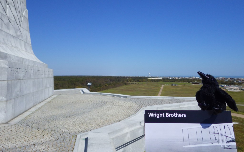
The Wright Brothers hailed from Dayton, Ohio but they came to the Outer Banks of North Carolina for the sustained winds they needed to get their winged contraptions off the ground.  They glided from the top of Kill Devil Hill more than a thousand times between 1900 and 1902.  Then on December 17, 1903 they finally made history: twelve-seconds of motor-powered, man-carrying flight in a heavier-than-air airplane.  After the fourth and longest flight (59 seconds) that day the flying machine was irreparably crashed and the brothers headed back to Ohio. 

Highlights

Museum, replica flyer and glider, monument, sculpture

Must-Do Activity

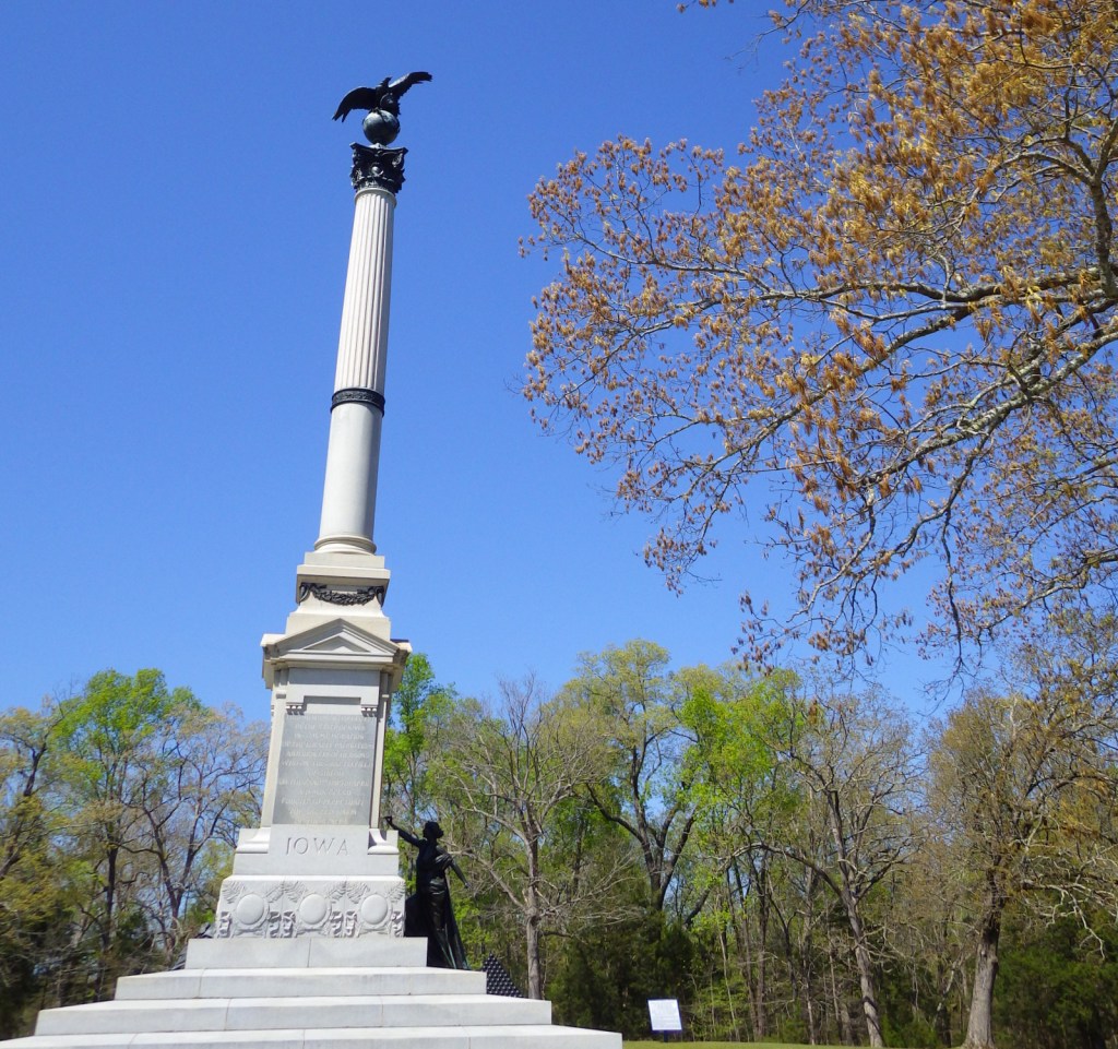
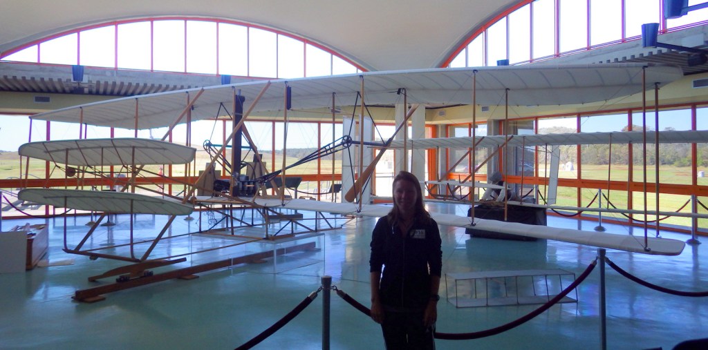
Since 1932, a massive granite monument has stood atop the 90-foot tall hill, which is actually a sand dune stabilized with planted grass.  Visitors to Kitty Hawk will also find a replica flyer and glider, reconstructed hangar, boulders marking the landing spot of each of the four flights, and a life-size bronze sculpture added on the first flight centennial in 2003. 

Best Trail

A paved walkway connects the Wright Brothers Monument atop Kill Devil Hill with the five boulders marking the lift-off point and four landings that occurred on December 17, 1903.

Instagram-worthy Photo

A full-scale replica of the 1903 flyer is located inside the museum run by the National Park Service (NPS).  Rangers give lectures in that room throughout the day, also explaining details of the replica 1902 glider.

Peak Season

Summer and every December 17

Hours

https://www.nps.gov/wrbr/planyourvisit/hours.htm

Fees

$10 per person or America the Beautiful pass

Road Conditions

All roads paved

Camping

There are NPS campgrounds located south of the memorial in Cape Hatteras National Seashore.

Related Sites

Dayton Aviation Heritage National Historical Park (Ohio)

Fort Raleigh National Historic Site (North Carolina)

Cape Hatteras National Seashore (North Carolina)
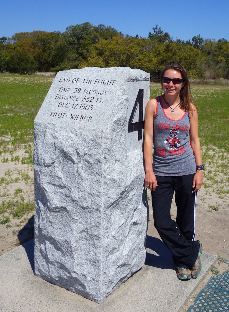
Explore More – The 1903 flyer on display here is a replica, so where is the original exhibited?

We are a participant in the Amazon Services LLC Associates Program, an affiliate advertising program designed to provide a means for us to earn fees by linking to Amazon.com and affiliated sites.

Little Bighorn Battlefield National Monument

Overview

You may not recall the 1876 battle at the Little Bighorn River in southern Montana, but most Americans (even children) recognize its label “Custer’s Last Stand.”  For such a relatively minor skirmish in the bloody 1800s, it has an outsized legend that only grows with time.  At this site more than 140 years ago, a large portion of the 7th U.S. Cavalry met their demise for tactical reasons still debated to this day.  The blame is generally placed upon Lieutenant Colonel George Armstrong Custer who was believed to be jockeying for a presidential nomination in the 1876 election.  Today this National Park Service (NPS) site is located on the Crow Indian Reservation in southern Montana, just off Interstate 90.

Highlights

Museum, Custer National Cemetery, driving tour, Last Stand Hill, Indian Memorial

Must-Do Activity

On June 25, 1876, with only 600 soldiers, Custer attempted to defeat a temporary village composed of multiple tribes numbering over 7,000 individuals.  Never before had so large an American Indian encampment been collected anywhere on the Great Plains.  Renowned war chiefs Sitting Bull, Crazy Horse, Two Moons, and many others have their words memorialized at the Indian Memorial, not built at Little Bighorn Battlefield National Monument until 1997 near the mass grave on Last Stand Hill.  Be sure to come in late June for the opportunity to witness a historical reenactment of the famous battle, which is held on the Crow Indian Reservation adjacent to the 765-acre National Monument.

Best Trail

None

Instagram-worthy Photo

The Battle of the Little Bighorn Reenactment is a two-hour, fully narrated presentation explaining the significance of the Battle of the Greasy Grass (as the American Indians call it).  The site of the reenactment is a ford where Lieutenant Colonel Custer’s battalion came closest to the encampment where 1,800 warriors of the Sioux, Cheyenne, and Arapahoe Nations were gathered to protect their families.  American Indian riders go bareback, leaping on and off their ponies with ease, while saddled 7th U.S. Cavalry re-enactors splash through the fast-flowing Little Bighorn River astride powerful horses.

Peak Season

Summer (the best time of year to visit is around the June 25 anniversary when a reenactment of the battle is held)

Hours

https://www.nps.gov/libi/planyourvisit/hours.htm

Fees

$25 per vehicle or America the Beautiful pass

Road Conditions

All roads paved

Camping

There is a small, private campground at the exit from Interstate 90, but the nearest NPS campground is 40 miles away at Bighorn Canyon National Recreation Area.

Related Sites

Washita Battlefield National Historic Site (Oklahoma)

Big Hole National Battlefield (Montana)

Devils Tower National Monument (Wyoming)

Explore More – When was Custer National Cemetery originally established and when did it become part of a National Monument?

World War II Memorial

Overview

The World War II Memorial in Washington, D.C. was dedicated in 2004 to remember the 16-million Americans that served in uniform during the war.  It is located on the National Mall between the Washington Monument and Lincoln Memorial.  The seven-acre site is managed by the National Park Service (NPS).  There is not an NPS visitor center at the site, but there are information kiosks around the area, including two near the Lincoln Memorial.

Highlights

Pavilions, pillars, bas-relief sculptures, fountains

Must-Do Activity

The memorial’s design was chosen in a competition with more than 400 others and was created in 1997 by Austrian-born architect Friedrich St. Florian.  It features a large pool and fountains, two pavilions labeled Atlantic and Pacific, 56 pillars for each state and territory, as well as bas-relief sculptures and quotes from historic figures.  On the Freedom Wall, each gold star represents one hundred of the 405,399 Americans who died during World War II.

Best Trail

Walk the bridge across the Potomac River to Arlington, Virginia for a view of the U.S. Marine Corps War Memorial that depicts the American flag being raised over Mount Suribachi on Iwo Jima during World War II.  This is technically part of George Washington Memorial Parkway (another NPS site), and offers a commanding view of the National Mall and is especially photogenic at night.

Instagram-worthy Photo

After dark is a great time for photography on the National Mall, and the World War II Memorial is no exception.  You might consider bringing a tripod for clearer photos.

Peak Season

Spring

Hours

24 hours a day with NPS rangers posted until 10 p.m.

https://www.nps.gov/wwii/planyourvisit/hours.htm

Fees

None

Road Conditions

All roads are paved, but public transportation is recommended in Washington, D.C.

Camping

There are no NPS campgrounds in the Washington, D.C., so it might be best to head for Shenandoah National Park in Virginia.

Related Sites

World War I Memorial (District of Columbia)

Franklin Delano Roosevelt Memorial (District of Columbia)

Korean War Veterans Memorial (District of Columbia)

Explore More – The memorial contains two hidden “Kilroy was here” engravings; what is the significance of this inclusion?

.

Shiloh National Military Park

Overview

Following the victory at Fort Donelson, Union General Ulysses S. Grant moved his 50,000 troops aboard steamboats down the Tennessee River to Pittsburg Landing.  The army camped near a log church named the Shiloh Meeting House where they awaited the marching Army of Ohio before advancing on the important railroad crossroads in Corinth, Mississippi.  The Confederate army launched a surprise attack on April 6, 1862, pushing the enemy lines back two miles before Union reinforcements finally arrived.  After two days and 23,746 soldiers killed, wounded, captured, or missing, the Confederates abandoned the field and Corinth.  There were an additional 7,000 casualties when they failed to recapture the town in October 1862.

Highlights

Museum, film, driving tour, Shiloh Meeting House, Indian mounds, cannons

Must-Do Activity

Start with the great 45-minute movie at the National Park Service (NPS)  visitor center then take the 12.7-mile driving tour with twenty stops that passes 150 commemorative monuments, 229 cannons, and 4,000 graves in Shiloh National Cemetery.  The site also contains 800-year-old American Indian mounds within a 45-acre National Historic Landmark.  A free pass to the Tennessee River Museum in Savannah is also provided at the NPS visitor center.  In addition to the NPS unit in Shiloh, Tennessee, there is an Interpretive Center 22 miles away in Corinth, Mississippi. 

Best Trail

The short trail through the 800-year-old Indian mounds provides views of the Tennessee River.

Instagram-worthy Photo

A reconstruction of the Shiloh Meeting House log church is found along the driving tour.

Peak Season

Summer

Hours

https://www.nps.gov/shil/planyourvisit/basicinfo.htm

Fees

None

Road Conditions

All roads paved

Camping

None in the park, but Pickwick Landing State Park is located 15 miles to the southeast.

Related Sites

Fort Donelson National Battlefield (Tennessee-Kentucky)

Stones River National Battlefield (Tennessee)

Vicksburg National Military Park (Mississippi)

Explore More – Originally managed by the U.S. military, when was this park established?

Blackstone River Valley National Historical Park

Overview

Roger Williams National Memorial used to be the only National Park Service (NPS) site in Rhode Island, but in 2014 Blackstone River Valley was upgraded from an affiliated National Heritage Corridor to a National Historical Park.  It commemorates the industrial revolution that changed the landscape of America during the 1800s, as well as the immigration of factory workers that changed its face.  Another NPS-affiliated point of interest in the tiny state is Touro Synagogue National Historic Site (admission charged) in Newport.

Highlights

Slater Mill Historic Site, Blackstone River State Park, Statue of Hope Fountain

Must-Do Activity

Formerly known as the John H. Chafee Blackstone River Valley National Heritage Corridor, this NPS unit remains a partnership between government agencies, non-profits, and businesses in Massachusetts and Rhode Island.  Its centerpiece is the nation’s first successful water-powered cotton-spinning factory: Slater Mill Historic Site in Pawtucket, Rhode Island, which offers free ranger-guided tours.  By 1880, this “hardest working river” was one of the most polluted in the country, but has recovered so that canoeists can float portions of its 46-mile length.

Best Trail

Blackstone River State Park has a free museum (inside the Kelly House) and a section of the canal that followed the river.  There are 3.5 miles of the 14-mile (of a planned 48) paved bikeway along the canal towpath within this Rhode Island park.  Another section of trail lies within Blackstone River and Canal Heritage State Park near River Bend Farm in Massachusetts.

Instagram-worthy Photo

The Statue of Hope Fountain was dedicated on November 12, 1904 in the town of Hopedale, Massachusetts.  It was carved from Carrara marble by Waldo Story and was once considered the “finest drinking fountain in the United States.” We found it a little creepy looking.

Peak Season

Summer

Hours

https://www.nps.gov/blrv/planyourvisit/hours.htm

Fees

None

Road Conditions

All major roads paved

Camping

Rhode Island State Parks manages several campgrounds, including George Washington State Campground in Chepachet.

Related Sites

Roger Williams National Memorial (Rhode Island)

New Bedford Whaling National Historical Park (Massachusetts)

Lowell National Historical Park (Massachusetts)

Explore More – When did English immigrant Samuel Slater take over a failed mill to start the first successful water-powered cotton-spinning factory in America?