Tag Archives: red rocks

Rainbow Bridge National Monument

Rainbow Bridge National Monument

Utah

Managed by National Park Service

Established 1910

160 acres

Website: nps.gov/rabr

Overview

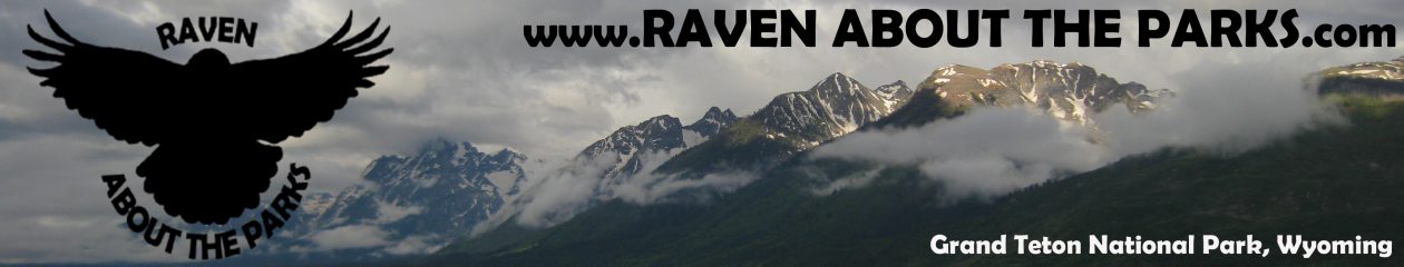
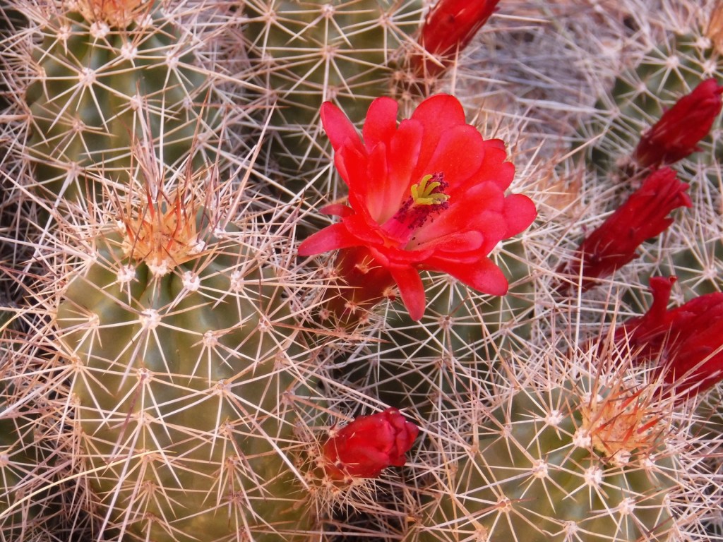
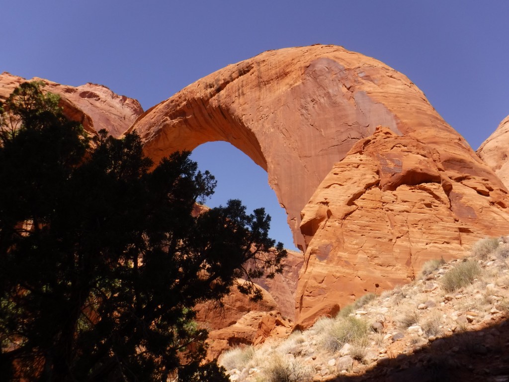
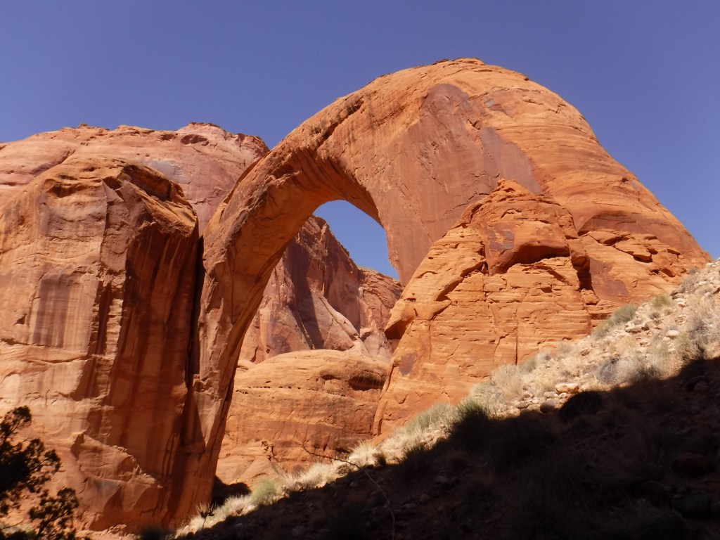
The statistics on Rainbow Bridge are impressive: it spans 275 feet with a height of 290 feet (compare that to the 151-foot-tall Statue of Liberty), and the sandstone at its top is 42 feet thick and 33 feet wide.  Before geologists started lumping together natural bridges and arches, it was considered the largest natural bridge in the world formed by water running underneath it.  The Navajo and other tribes consider Rainbow Bridge sacred and request that nobody walks beneath its span.  When Glen Canyon Dam was completed in 1963, many archaeological sites were submerged beneath Lake Powell and at the reservoir’s peak volume this sacred site has had water reach to its base.  The National Park Service (NPS) manages Rainbow Bridge National Monument as part of Glen Canyon National Recreation Area that straddles the Utah-Arizona border.

Learn more about the other 137 National Monuments in our book Monumental America: Your Guide to All 138 National Monuments. It is now available for sale on Amazon.com.

Highlights

Boat ride, Rainbow Bridge

Must-Do Activity

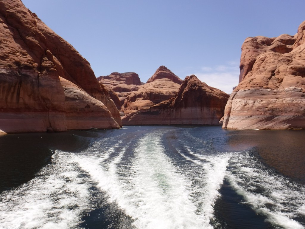
The NPS runs Carl Hayden Visitor Center in Page, Arizona, which is a good place to plan a visit to Rainbow Bridge or purchase tickets for a Glen Canyon Dam tour.  If you do not want to attempt to navigate 50 miles one-way in your own boat (rentals available), there are all-day commercial boat trips into Bridge Canyon.  Depending on the water level, the hike from the boat dock to the first overlook of the natural bridge is around one-mile one-way and is not wheelchair accessible.  Photos do not do Rainbow Bridge justice, and you must see it for yourself to truly appreciate the size of this entry on our Top 10 NPS Sites for Natural Bridges/Arches

Best Trail

There is always a hike from the boat dock to the overlook, but if you are in good shape continue on the trail around to the left to see the other side of Rainbow Bridge.  With proper permits from the Navajo Nation in Window Rock, Arizona, it is possible to backpack into the site on either a 14-mile or 17-mile trail. 

Photographic Opportunity

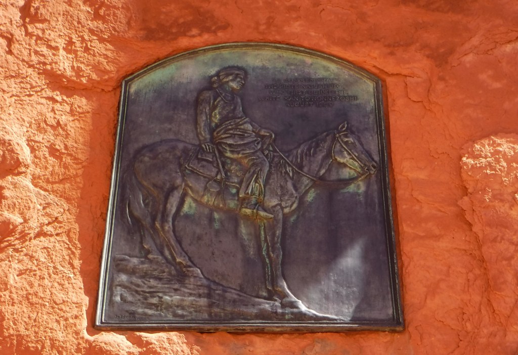
Obviously, Rainbow Bridge is the star attraction here.  Navajo legends tell how one of the Hero Twins was saved from drowning when his father Jo’hanaa’éí (the Sun) sent a rainbow, later turned to stone to symbolize a father’s love.  Another story says a measuring worm turned itself to stone to save both Hero Twins.

Peak Season

Spring and fall

Hours

https://nps.gov/rabr/planyourvisit/hours.htm

Fees

There is a $30 per vehicle entrance fee at the two marinas in Page (America the Beautiful passes accepted), in addition to charges for guided boat tours.

Road Conditions

The roads are paved to the marinas in Page, Arizona.  Glen Canyon National Recreation Area is famous for its backcountry 4×4 roads (like Hole-in-the-Rock Road) and flash floods, so check with a park ranger before attempting anything unpaved.  A fee is charged to ferry across Lake Powell between Halls Crossing and Bullfrog Marina.

Camping

There are several developed campgrounds in Glen Canyon National Recreation Area (mostly near marinas), but free primitive camping is also allowed along most dirt roads.  A permit is required for backpack camping in the beautiful Coyote Gulch area off Hole-in-the-Rock Road.

Related Sites

Natural Bridges National Monument (Utah)

Capitol Reef National Park (Utah)

Navajo National Monument (Arizona)

Explore More – Where along the trail to the Rainbow Bridge overlook is the three-toed dinosaur print found in the sandstone?

Learn more about the other 137 National Monuments in our book Monumental America: Your Guide to All 138 National Monuments

Dixie National Forest

Dixie National Forest

Utah

Managed by U.S. Forest Service, Intermountain Region

1,967,165 acres (1,889,127 federal/ 78,038 other)

Website: https://www.fs.usda.gov/dixie

Overview

Dixie National Forest is spread across southwest Utah surrounding Cedar Breaks National Monument and near three National Parks: Bryce Canyon, Capitol Reef, and Zion.  The National Forest has a wide elevation range from 2,800 feet near St. George to 11,322 feet on Boulder Mountain.  The change in average temperature and precipitation leads to wide variety of ecosystems from a desert-like environment all the way up to subalpine conifer forests and tundra.  The warmth of southern Utah reminded some early emigrants of “Dixie,” the part of the U.S. south of the Mason-Dixon Line, but with growing public distaste for that name it may be changed in the future.

Highlights

Markagunt National Scenic Byway, Brian Head, Navajo Lake, Cascade Falls, Strawberry Point, Red Canyon Recreation Area, Honeycomb Rocks, Powell Point, Hell’s Backbone Bridge, Virgin River Rim Trail, Hancock Peak Trail, Whipple Trail, Casto Canyon Trail

Must-Do Activity

Highway 12 Scenic Byway winds through much of the National Forest, including Red Canyon Recreation Area where the popular Casto Canyon Trail is open to hikers, bicycles, horses, and ATVs.  The mountain ranges west of Interstate 15 are a less-visited section of the forest, with numerous trails traversing the Pine Valley Mountains Wilderness, including the 35-mile Summit Trail.

Best Trail

Leaving from a trailhead across Highway 143 from the road to the top of 11,312-foot-tall Brian Head, Rattlesnake Creek Trail skirts the edge of spectacular Cedar Breaks National Monument and enters the Ashdown Gorge Wilderness (established in 1984).  About one mile in, one of several side trails leads off to the left for an overlook of the Cedar Breaks, a red rock badlands full of hoodoos situated at the edge of the Markagunt Plateau.  Gnarled Great Basin bristlecone pine trees cling to the eroding edge of the natural amphitheater, making a great foreground for photographs with a beautiful backdrop.  The trail continues to drop more than 2,400 feet to the canyon bottom over four miles connecting with Ashdown Creek which eventually crosses Highway 14, but there is not an official trailhead there.

Watchable Wildlife

A variety of mammals call Dixie National Forest home: black bears, mountain lions, bobcats, coyotes, three species of foxes, minks, pine martens, porcupines, beavers, raccoons, skunks, badgers, snowshoe hares, pika, mountain goats, bighorn sheep, elk, mule deer, and pronghorns.  Large birds include bald eagles, golden eagles, California condors, turkey vultures, wild turkeys, and various species of woodpeckers.  There are many gamefish found in the streams and small lakes spread across the high-elevation Markagunt, Paunsaugunt, and Aquarius Plateaus.

Instagram-worthy Photo

South of Torrey, Highway 12 climbs into an aspen forest with incredible views of Capitol Reef National Park and Waterpocket Fold.

Peak Season

Late summer

Fees

None

Road Conditions

Highway 12 and Highway 143 are paved roads that access the high elevations of Dixie National Forest, but they may be closed seasonally due to snow.  There are numerous dirt roads that traverse the area, including the popular route to the top of 11,312-foot-tall Brian Head.

Camping

There are numerous campgrounds located throughout the National Forest, as well as dispersed camping opportunities on dirt roads west of Bryce Canyon National Park.

Wilderness Areas

Ashdown Gorge Wilderness

Box-Death Hollow Wilderness

Cottonwood Forest Wilderness

Pine Valley Mountains Wilderness

Related Sites

Cedar Breaks National Monument (Utah)

Grand Staircase-Escalante National Monument (Utah)

Capitol Reef National Park (Utah)

Nearest National Park

Bryce Canyon

Conifer Tree Species

Utah juniper, singleleaf pinyon pine, ponderosa pine, Douglas-fir, Engelmann spruce, subalpine fir, Great Basin bristlecone pine

Flowering Tree Species

quaking aspen, Bebb willow

Explore More – On the Markagunt Plateau, Navajo Lake drains out of two lava tubes that formed how many millions of years ago?

Learn more about this and the 154 other National Forests in our new guidebook Out in the Woods

We are a participant in the Amazon Services LLC Associates Program, an affiliate advertising program designed to provide a means for us to earn fees by linking to Amazon.com and affiliated sites.

Zion National Park

Zion National Park

Utah

Managed by National Park Service

Established 1909 National Monument, 1919 National Park

146,598 acres

Website: nps.gov/zion

Overview

Zion National Park protects an outstanding canyon where steep sandstone walls up to 3,000 feet high appear to glow at sunrise and sunset.  Views are great from the road along the North Fork of the Virgin River, but to really get a sense of scale here you have to hike uphill on one of many trails.  Check out a new film on the park here: https://zionpark.org/wethekeepers/

Learn more in our guidebook to the National Parks, A Park to Yourself: Finding Adventure in America’s National Parks (available on Amazon).

Highlights

Kolob Canyons, The Narrows, Emerald Pools, Weeping Rock, Observation Point, The Subway, Angels Landing, Canyon Overlook Trail

Must-Do Activity

Kolob Canyons is in the northern section of the park located just off Interstate 15, where a short drive leaves the road noise behind and opens up a world of red rock beauty.  There are no campgrounds in this area of the park, so we picked up a backpacking permit at the visitor center to spend the night near Timber Creek.  The flowing water meant croaking frogs and toads provided a chorus throughout the night.  This site provided a good jumping off point for the La Verkin Creek Trail which travels 7.5 miles one-way to Kolob Arch.  At 310 feet across, this arch is one of the biggest in the world, but you cannot get nearly as close to it as you can to those at Arches National Park.  Hiking anywhere in Kolob Canyons is much less busy than other parts of Zion National Park, but the trails can be snow covered in the winter (when the access road sometimes closes).

Best Trail

The Narrows, Angels Landing, and The Subway are hiking destinations known around the world, and their popularity means they each require a reservation.  Wading upriver through the frigid water of the Narrows, where the canyon pinches to only 18 feet wide in places, is an essential experience open to all visitors for the first five miles to Big Spring.  The busy 5.4-mile out-and-back trail to Angels Landing is not for the faint of heart as it follows a knife-edge route with chains mounted in places.  But it is worth the effort, even if you just make it to the saddle at the end of Walter’s Wiggles, perhaps the world’s most famous trail switchbacks.

Instagram-worthy Photo

We watched a huge California condor flying over Zion Canyon from Observation Point, a popular eight-mile out-and-back hike that leaves from the same trailhead as Weeping Rock.

Peak Season

Spring and fall

Hours

https://nps.gov/zion/planyourvisit/hours.htm

Fees

$35 per vehicle or America the Beautiful pass

Road Conditions

The main roads into Kolob Canyons and Zion Canyon are paved, but a free shuttle bus is required to enter the dead end Zion Canyon Scenic Drive from 7 a.m. to 7 p.m. daily from March to November (click here for more shuttle information).  There is an extra fee for large RVs to use the Zion-Mount Carmel Tunnel, since they require a pilot car and the road must be shut down to one-way traffic only.

Camping

There is not a campground in Kolob Canyons, but in Zion Canyon you can wake up to an awesome morning view in sprawling Watchman or South Campgrounds.  Lava Point Campground is located down the long, unpaved Kolob Terrace Road and is closed in the winter.  Dispersed camping is allowed by the Bureau of Land Management outside park boundaries, but it can be hard to find an open spot.

Related Sites

Bryce Canyon National Park (Utah)

Cedar Breaks National Monument (Utah)

Dixie National Forest (Utah)

Explore More – Walter’s Wiggles may be the world’s most famous trail switchbacks, so who are they named after?

This design we created to celebrate Zion National Park is available on a variety of products at Cafe Press and Amazon.

Explore More – Walter’s Wiggles may be the world’s most famous trail switchbacks, so who are they named after?

We are a participant in the Amazon Services LLC Associates Program, an affiliate advertising program designed to provide a means for us to earn fees by linking to Amazon.com and affiliated sites.

Coconino National Forest

Coconino National Forest

Arizona

Managed by U.S. Forest Service, Southwestern Region

2,013,804 acres (1,855,955 federal/ 157,849 other)

Website: https://www.fs.usda.gov/coconino/

Overview

Coconino National Forest has an elevation range of 10,000 feet from the Verde River up to 12,637-foot Mt. Humphreys, the highest point in Arizona.  It borders four other National Forests: Kaibab, Prescott, Sitgreaves, and Tonto.  The National Forest encompasses two busy recreational areas: the red rocks around Sedona and the San Francisco Peaks north of Flagstaff.  While in college for three years at Northern Arizona University, Scott probably hiked 100 different trails and more than 1,000 miles through Coconino National Forest.  He and his Siberian husky would often wake up early to get a hike in before class, including one moonlit summiting of Mt. Humphreys completed in time for an 8 a.m. lecture. See where it ended up on our list of Top 10 Summit Trails in National Forests.

Highlights

Oak Creek Canyon, Bell Rock, Vultee Arch, Cathedral Rock, Sycamore Canyon, Honanki Ruins, Wet Beaver Creek, San Francisco Peaks, Mt. Humphreys, Lockett Meadow, Mt. Elden, West Clear Creek, Upper Lake Mary, West Fork Trail, Kachina Trail, Bear Jaw Canyon Trail, Dixon Lewis Trail

Must-Do Activity

North of Sedona is the deep, shady Oak Creek Canyon that houses a diversity of plant species, including riparian trees like sycamore and walnut.  The steep, forested walls make for beautiful scenery, but also create ideal conditions for crown fires as evidenced in 2006 and 2014.  The steep Wilson Mountain South Trail #10 provides extraordinary panoramas and the shady West Fork Trail #108 is perfect on hot summer days, though in the winter it is also beautiful covered in snow and ice.  The remains of the historic lodge and orchard at the latter site provide a glimpse into the past of a place immortalized in Zane Grey’s novel The Call of the Canyon.  Continue driving north up Highway 89A for unforgettable hairpin turns that lead to Oak Creek Vista and on to Flagstaff.

Best Trail

The San Francisco Peaks are the remains of an extinct volcano that forms the dramatic mountain skyline north of Flagstaff.  You cannot actually see the highest summit (12,637-foot Mt. Humphreys) from town, but you will if you drive Highway 180 toward Grand Canyon National Park.  The shortest route to the top leaves from 8,800 feet at Arizona Snowbowl Ski Resort and is nine miles roundtrip.  For the more adventurous: start on the Inner Basin Trail from Lockett Meadow (now requires three-mile hike on closed road), hike 19 miles roundtrip via the Weatherford Trail, or tack on seven miles to Snowbowl on the scenic Kachina Trail.  The San Francisco Peaks are beautiful (especially when aspen trees turn in the fall), but can be dangerous during thunderstorms that occur almost every afternoon during monsoon season.   Nostalgia may have been a factor in naming this #1 on the list of Top 10 National Forests for Day Hiking.

Watchable Wildlife

Elk are the most prevalent charismatic megafauna in Coconino National Forest, although mule deer and pronghorns are also common.  We have encountered black bears in the San Francisco Peaks and rattlesnakes in Sycamore Canyon.  Tassel-eared squirrels are the noisiest residents of the ponderosa pine forests, enough so that Bertie the talking squirrel became the main character in the children’s book Scott illustrated while working for the Ecological Restoration Institute at Northern Arizona University.

Instagram-worthy Photo

The cliff dwelling in Sedona’s Lost Canyon is in a beautiful spot overlooking a wide green valley that cuts between the red rock buttes and escarpments.  There is water in this narrow canyon, feeding the tall Arizona cypress trees below.  Just outside the cave, juniper trees offered firewood, pinyon pine produced edible nuts, and yucca plants provided thread for its former residents.  To the north numerous canyons drain the ponderosa pine forests where elk and mule deer reside in the summer.

Peak Season

Summer

Fees

A day-use fee applies at nearly every trailhead in Sedona, but an America the Beautiful pass can be substituted. A $6 online reservation per vehicle is required to park at Dixon Lewis (formerly Waterfall) Trail to Fossil Creek from April 1 to October 1.

Road Conditions

Most of the dirt roads through Coconino National Forest are well maintained, especially around Sedona.  One exception to that is Woody Mountain Road that requires high-clearance once you get past the first 20 miles or so towards the Mogollon Rim above Sycamore Canyon.

Camping

Lockett Meadow Campground is special place that came in at #4 on our Top 10 Campgrounds in National Forests list.  However, camping there now requires a three-mile hike up the road since it closed following the Pipeline Fire (which does mean you are more likely to get a campsite). The coveted campsites in Oak Creek Canyon on scenic Highway 89A are full throughout the summer and fall (online reservations available).

Wilderness Areas

Fossil Springs Wilderness

Kachina Peaks Wilderness

Kendrick Mountain Wilderness (also in Kaibab National Forest)

Mazatzal Wilderness (also in Tonto National Forest)

Munds Mountain Wilderness

Red Rock-Secret Mountain Wilderness

Strawberry Crater Wilderness

Sycamore Canyon Wilderness (also in Prescott and Kaibab National Forests)

West Clear Creek Wilderness

Wet Beaver Wilderness

Related Sites

Sunset Crater Volcano National Monument (Arizona)

Montezuma Castle National Monument (Arizona)

Walnut Canyon National Monument (Arizona)

Nearest National Park

Petrified Forest

Conifer Tree Species

ponderosa pine, limber pine, Rocky Mountain bristlecone pine, two-needle pinyon pine, Douglas-fir, subalpine fir, white fir, Engelmann spruce, alligator juniper, one-seed juniper, Utah juniper, Rocky Mountain juniper, Arizona cypress

Flowering Tree Species

Gambel oak, quaking aspen, New Mexico locust, boxelder, bigtooth maple, Arizona sycamore, Arizona walnut, Arizona alder, velvet ash

Explore More – What is largest natural lake in the state of Arizona, which is found atop Coconino National Forest’s Anderson Mesa (although it is often dried up in the summer)?

Learn more about this and the 154 other National Forests in our travel guidebook Out in the Woods

Canyon de Chelly National Monument

Overview

In the heart of the Navajo Nation in northeast Arizona lies Canyon de Chelly National Monument.  Humans have inhabited this area for 4,500 years, leaving behind numerous pictographs and the dramatic ruins of Ancestral Puebloan cliff dwellings.  The Navajo arrived in this region around AD1700 with sheep they gained from Spanish colonists which they utilized to weave intricate wool blankets.  Wars with the Utes, Spanish, Mexicans, and then U.S. government eventually led to their forced migration (“The Long Walk”) to Bosque Redondo in New Mexico around 1864.

Highlights

Spider Rock Overlook, White House Ruin, guided vehicle tours, horseback tours

Must-Do Activity

Four years after being forced to the uninhabitable Bosque Redondo, the Navajo were granted the largest reservation in the country and families still inhabit Canyon de Chelly (pronounced “d’shay”) to this day.  The 84,000-acre National Monument is administered cooperatively with the National Park Service (NPS).  However, entrance into the canyon is limited to guided trips and one publicly accessible trail that drops 500 feet to White House Ruin.  Overlooks along the North and South Rim Drives (17 and 18 miles respectively) are free and open year-round, though.  It not only seems like everything runs on a different clock here, but, unlike the rest of Arizona (and now New Mexico), the Navajo Nation observes Daylight Savings Time, so is always an hour later in the summer months (the same time as New Mexico until the fall).

Best Trail

White House Ruin was inhabited AD1060-1275 and is named for the white plaster used to coat the wall in the upper dwelling.  The 2.5-mile roundtrip White House Trail drops down the canyon wall and cuts through a tunnel.

Instagram-worthy Photo

At the end of South Rim Drive is 800-foot tall Spider Rock, a great spot to watch the sun set, which is an ideal time to photograph the canyon’s red sandstone walls.

Peak Season

Summer

Hours

https://www.nps.gov/cach/planyourvisit/hours.htm

Note that there is typically a time difference because Arizona and New Mexico do not observe Daylight Savings Time.

Fees

There is no entrance fee for the North and South Rim Drives, but guided tours into the canyon do charge admission.

Road Conditions

All roads open to the public are paved, but guided tours can be very bumpy since they use the canyon bottom as a road.

Camping

The NPS runs Cottonwood Campground with 96 spaces (and running water in the summer) in a grove of Fremont cottonwood trees that turn yellow in the late autumn.  Guided camping trips in the canyon are also available.

Related Sites

Grand Canyon National Park (Arizona)

Navajo National Monument (Arizona)

Hubbell Trading Post National Historic Site (Arizona)

Explore More – How many millions of years ago did sand dunes turn into Canyon de Chelly’s red sandstone?