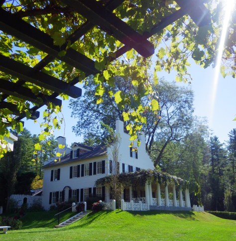
The only site in New Hampshire administered by the National Park Service (NPS) is dedicated to Augustus Saint-Gaudens, an Irish born immigrant that studied art in Paris and Rome. On this country estate he utilized beginning in 1885, he converted a barn into his sculpture studio. Other artists flocked to “Aspet” until his death in 1907.
Highlights
Home and sculptures of famous 19th-century artist, sculptor-in-residence program
Must-Do Activity
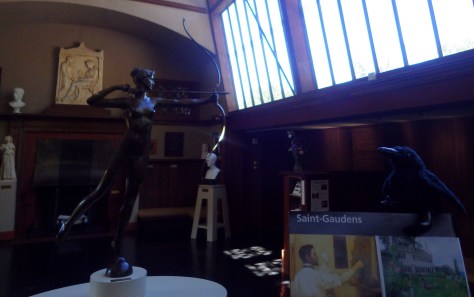
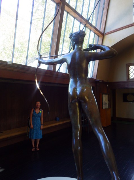
A tour ticket is required to enter the house and is included with your admission fee. While you are waiting, explore the many marble, plaster, and bronze castings of Saint-Gaudens’ work located around the property, including his famous Shaw Memorial whose original can still be found in Boston. A new cast of one of his Abraham Lincoln statues was added in 2016 during the NPS Centennial.
Best Trail
The quarter-mile Ravine Trail starts at the Ravine Studio, the workshop of the sculptor-in-residence. Blow-Me-Down Trail runs 2 miles between the Temple and a swimming hole.
Instagram-worthy Photo
Take a photo of “Aspet” house from the porch of Little Studio framed by the vine-draped arbor.
None at this park, but Mt. Ascutney State Park is short drive away across the border in Vermont.
Covered bridge connecting New Hampshire and VermontScott with a huge honeylocust tree
The Shaw Memorial took Saint-Gaudens 14 years to complete. This cast was completed in 1997.Diana sculptures like this top Madison Square Garden in New York City.
Explore More – Why does the gift shop sell a stuffed animal goat named Seasick?
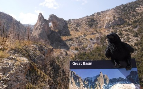
Originally designated a National Monument in 1922, the area surrounding 13,063-foot Wheeler Peak became a National Park in 1986. This park is so remote that moonless nights offer some of the darkest skies you will see in your entire life. Plan to stay multiple nights to walk along the scenic Alpine Lakes Loop Trail, summit the peak, visit Lexington Arch, hike through a grove of ancient trees, and take a guided tour of Lehman Caves.
Highlights
Wheeler Peak Scenic Drive, Lehman Caves, Lexington Arch, bristlecone pine trees
Must-Do Activity
Pass through ancient bristlecone pine trees on your hike to the only remaining glacier in the state of Nevada. This park was once home to the oldest single-stem tree in the world with nearly 5,000 annual rings (a cross-section is on display at the Great Basin Visitor Center). It was killed by a researcher who cut it down to count it in 1964, but he then became a major advocate for creating the national park.
Best Trail
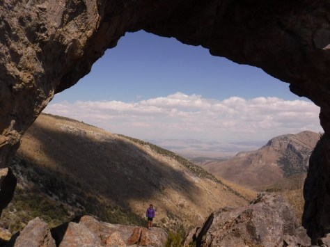
Lexington Arch is located down a long dirt road, the first nine miles of which are passable by any vehicle, but the final two miles require four-wheel-drive. From the trailhead, the hike is 1.7-miles one-way, for a total round trip of 7.4 miles if you park where we did. Lexington Arch is an impressive 60 feet tall and its limestone structure is unique since most arches are sandstone.
Instagram-worthy Photo
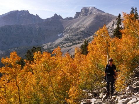
Gnarled branches of bristlecone pine trees reach for the sky at 10,000 feet in elevation. Wheeler Peak provides a great backdrop for them.
Peak Season
Summer, with September a great time of year to visit for changing colors in the aspen stands. Wheeler Peak Scenic Drive closes in winter.
None, which is fairly unique for a National Park, but there is a charge for cave tours.
Road Conditions
Wheeler Peak Scenic Drive is paved and most dirt roads are passable to all vehicles, with the exception of the final 2 miles of the road to Lexington Arch which requires four-wheel-drive.
Camping
There are several campgrounds in the park, plus dispersed sites along two dirt roads available with a permit. Dispersed camping is allowed on roads outside the park boundaries without a permit.
Wheeler Peak protects the only remaining glacier in Nevada from the afternoon sun.The steep trail to Wheeler Peak climbs over 3,000 feet in about four miles, but the destination is always in view.There was fresh snow atop 13,063-foot Wheeler Peak when we summited in mid-September.The Great Basin Visitor Center in Baker, Nevada displays a cross-section from the 4,900-year-old bristlecone pine tree.Ranger-guided tours of Lehman Caves are only a half-mile long and worth the price of admission.On the trail to Lexington ArchTiff standing on cave flowstone beneath Lexington Arch.Our original logo is for sale on a variety of products on Amazon and Cafe Press
Explore More – If the flowstone formations at its base indicate Lexington Arch was once part of a cave, is it actually an arch or a natural bridge?
We are a participant in the Amazon Services LLC Associates Program, an affiliate advertising program designed to provide a means for us to earn fees by linking to Amazon.com and affiliated sites.
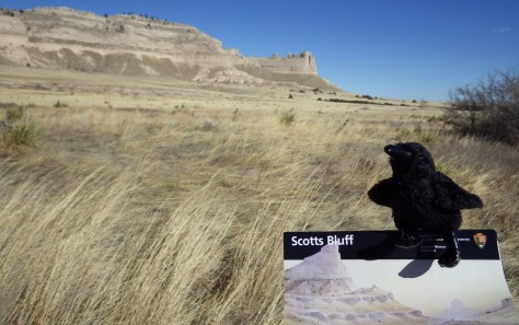
If the names of Scotts Bluff and Chimney Rock sound familiar, it is perhaps because you grew up playing The Oregon Trail computer game on a Macintosh in the early 1990s. The massive 800-foot tall sandstone cliffs enclosed within Scotts Bluff National Monument were once the unofficial one-third mark along the historic trail, as well as a landmark along the California Trail, the Mormon Pioneer Trail, and the short-lived Pony Express Trail.
Highlights
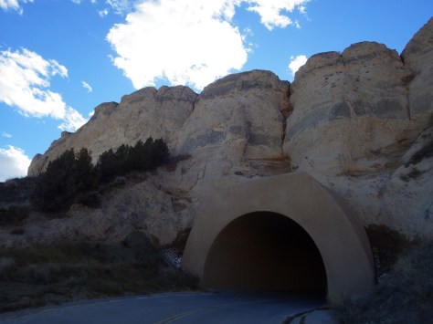
Museum, vistas, historic trail, only road tunnels in Nebraska
Must-Do Activity
While we recommend the hike to the top from the visitor center, you should probably also drive up there, because these are the only three tunnels dug for a road in the entire state of Nebraska.
Best Trail
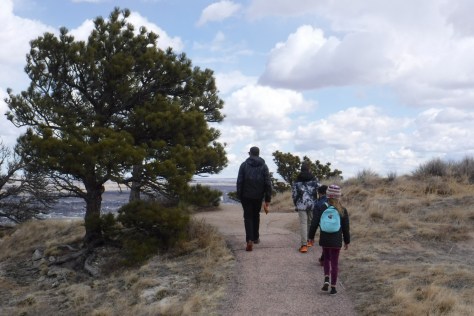
Saddle Rock Trail leads from the parking lot at the visitor center 1.6-miles up the 800-foot tall bluff through a tunnel carved in the sandstone for great views of distant Chimney Rock National Historic Site (an affiliated NPS unit), another prominent Nebraska landform noted by early emigrants.
Instagram-worthy Photo
Pose with the oxen sculptures pulling a wagon up Mitchell Pass in front of Scotts Bluff.
There is not a campground within the monument, but the adjacent cities of Scottsbluff and Gering have RV parks.
The only road tunnels in Nebraska are in this National Monument.
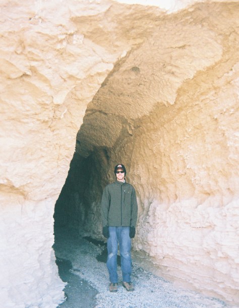
The trail on top of Scotts Bluff.Enjoy views of Scottsbluff, Nebraska and the North Platte River from atop the cliffs.Scott in the tunnel on Saddle Rock Trail.Drive east to Chimney Rock National Historic Site for another Nebraska landmark on the Oregon Trail.
Explore More – Did the U.S. Army abandon Fort Mitchell before or after completion of the transcontinental railroad?
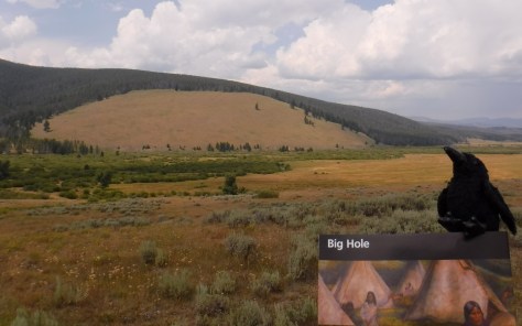
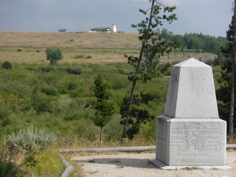
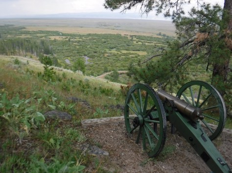
Big Hole National Battlefield is located in southwestern Montana, part of the larger Nez Perce National Historical Park, which spans four states. Back in 1877, following violent clashes with white settlers, five bands of the Nez Perce tribe left the Wallowa Valley of Oregon and were followed east by the U.S. Army. After the remaining 800 Nez Perce went over the mountains bypassing an Army blockade at Lolo Pass, they stopped to rest in the Big Hole Valley. A surprise attack by the U.S. Army on the morning of August 9, 1877 led to bloodshed on both sides, with Nez Perce warriors forcing the troops to retreat, capturing a Howitzer cannon, and allowing their women and children to escape towards Yellowstone National Park.
Highlights
Overlook from visitor center, interpretive film, trail to site of Nez Perce Camp
Must-Do Activity
Start at the visitor center for the 26-minute film and an overview of the battlefield. You are in for a treat if you happen to be around for a presentation by Dr. Bob Brown acting as Major Charles Rawn to describe his historic connection with the site.
Best Trail
The National Park Service visitor center overlooks the battlefield for orientation, and a paved road leads down to a trailhead to access the site of the attack (Nez Perce Camp), and a more strenuous climb to the Siege Area, army trenches, and the Howitzer capture site. Interpretive booklets are available for only $1.00.
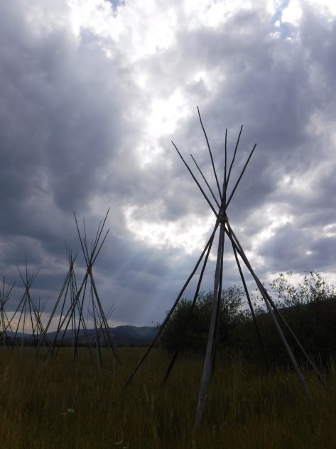
Instagram-worthy Photo
Montana is known for its Big Sky, which can be quite beautiful when pierced by the tale teepee poles set up at the site of the Nez Perce camp.
Peak Season
Open year round, but winters are long and snowy in this part of Montana, making summer the best time to visit.
All roads are paved and the Nez Perce Camp Trail is wide and flat enough to allow for wheelchairs.
Camping
None in the park, but campgrounds and dispersed camping can be found in nearby Beaverhead-Deer Lodge National Forest.
This monument was erected where U.S. Army troops were pinned down by sniper fire and dug trenches that are still visible today.The North Fork of the Big Hole River runs through the battlefield.The Howitzer capture site is at the end of a steep hike with great views.
Explore More – How long was the journey between Wallowa Lake, Oregon and Bear Paw Battlefield in northeastern Montana where 432 Nez Perce were finally captured?
North of Arkansas’ Buffalo National River on the Ozark Plateau is Ozark National Scenic Riverways, perhaps the wildest section of Missouri. Unlike the many reservoirs around Branson, here the Current and Jacks Fork Rivers flow freely and have been managed by the National Park Service since 1964. The best way to explore the serpentine park boundaries is on the water, but roads and trails access several areas.
Highlights
Canoeing/kayaking, Blue Spring, Alley Mill, karst landforms and caves
Must-Do Activity
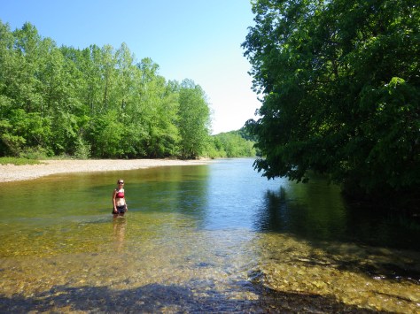
The crystal clear spring-fed water of the Jack’s Fork River is home to a variety of fish, birds, and even the occasional beaver. We paddled 25 miles from Buck Hollow to Alley Spring, a pleasant day trip.
Best Trail
The dolomite and limestone karst underneath this park is riddled with caves and sinkholes, like Devils Well, Round Spring Cave (ranger guided tours for a fee), and Jam Up Cave (only accessible from the Jack’s Fork River).
Instagram-worthy Photo
Hike to 310-foot deep Blue Spring (which was aptly called Spring of the Summer Sky by Native Americans) or drive to the bright red Alley Mill that dates back to 1894.
Peak Season
Spring offers peak water flows for canoeing/kayaking
None, but you can pay local concessionaires to rent canoes and shuttle your vehicle.
Road Conditions
Highways are paved and most dirt roads are narrow but passable with a passenger vehicle when dry
Camping
There are many campgrounds within Ozark National Scenic Riverways, some with full RV hookups and some primitive (we especially liked Bay Creek). Floaters on the Current and Jacks Fork Rivers are allowed to camp on gravel bars.
Jam Up Cave is only accessible by beaching your boat along the Jacks Fork River. Find this photo and others for sale on Imagekind
Scott at Blue Spring
Explore More – The colorful Blue Spring pumps out how many million gallons of water per day?
We are a participant in the Amazon Services LLC Associates Program, an affiliate advertising program designed to provide a means for us to earn fees by linking to Amazon.com and affiliated sites.
37.000729-91.016160
Start your U.S. National Forests, National Parks, and National Monuments adventure here!